
The Merritt Parkway is a controlled-access parkway in Fairfield County, Connecticut, with a small section at the northern end in New Haven County. Designed for Connecticut's Gold Coast, the parkway is known for its scenic layout, its uniquely styled signage, and the architecturally elaborate overpasses along the route. As one of the first, oldest parkways in the United States, it is designated as a National Scenic Byway and is also listed in the National Register of Historic Places. Signed as part of Route 15, it runs from the New York state line in Greenwich, where it serves to continue the Hutchinson River Parkway, to Exit 54 in Milford, where the Wilbur Cross Parkway begins. Facing bitter opposition, the project took six years to build in three different sections, with the Connecticut Department of Transportation constantly requiring additional funding due to the area's high property value. The parkway was named for U.S. Congressman Schuyler Merritt. In 2010, the National Trust for Historic Preservation called the Merritt Parkway one of "America's 11 Most Endangered Historic Places".

The Shetucket River is a tributary of the Thames River, 20.4 miles (32.8 km) long, in eastern Connecticut in the United States.
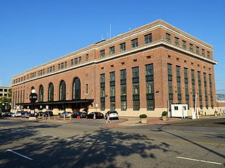
New Haven Union Station is the main railroad passenger station in New Haven, Connecticut. It is the third such station in the city of New Haven, preceded by both an 1848 built station in a different location, and an 1879 built station near the current station's location. Designed by noted American architect Cass Gilbert, the present beaux-arts Union Station was completed and opened in 1920 after the previous Union Station was destroyed by fire. It served the New York, New Haven and Hartford Railroad for the next five decades, but fell into decline following World War II along with the United States railroad industry as a whole.

The Eli Whitney Museum, in Hamden, Connecticut, is an experimental learning workshop for students, teachers, and families. The museum's main building is located on a portion of the Eli Whitney Gun Factory site, a gun factory erected by Eli Whitney in 1798. The museum focuses on teaching experiments that are the roots of design and invention, featuring hands-on building projects and exhibits on Whitney and A. C. Gilbert.
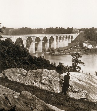
The Croton Aqueduct or Old Croton Aqueduct was a large and complex water distribution system constructed for New York City between 1837 and 1842. The great aqueducts, which were among the first in the United States, carried water by gravity 41 miles (66 km) from the Croton River in Westchester County to reservoirs in Manhattan. It was built because local water resources had become polluted and inadequate for the growing population of the city. Although the aqueduct was largely superseded by the New Croton Aqueduct, which was built in 1890, the Old Croton Aqueduct remained in service until 1955.
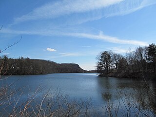
Lake Whitney is a lake in Hamden, Connecticut, that is a part of the Mill River. The lake was a water source for the New Haven, Connecticut, metro area, until its associated treatment plant became antiquated in the 1990s. A new water treatment facility was constructed in the early 2000s rated for up to 15 million gallons per day. Lake Whitney now serves as one of four primary sources of surface water for the RWASouth Central Connecticut Regional Water Authority. RWA also operates a gravity release from the dam when there is no flow over the spillway, and operates an "Eel Pass" in conjunction with CT DEEP to assist with eel migration over the dam.

Several neighborhoods of Norwich, Connecticut maintain independent identities and are recognized by official signs marking their boundaries. The following is a list of neighborhoods in Norwich.
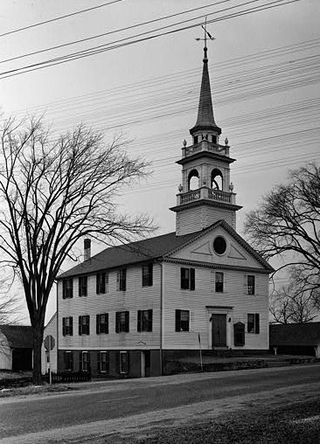
Preston City is a village and the original town center of the town of Preston, Connecticut, United States. The core of the village around the junction of Old Northwest Road and Route 164 is designated as the Preston City Historic District, a historic district that is listed on the National Register of Historic Places. The district is located along Old Shetucket and Amos Roads, which, prior to the 1930s, were major thoroughfares.

The Lowell Power Canal System is the largest power canal system in the United States, at 5.6 miles in length. It is operating through six major canals on two levels, controlled by numerous gates. The system was begun in the 1790s, beginning its life as a transportation canal called the Pawtucket Canal, which was constructed to get logs from New Hampshire down the Merrimack River to shipbuilding centers at Newburyport, Massachusetts, bypassing the 30-plus-foot drop of the Pawtucket Falls.

Norwichtown is a historic neighborhood in the city of Norwich, Connecticut, United States. It is generally the area immediately north of the Yantic River between I-395 and Route 169.
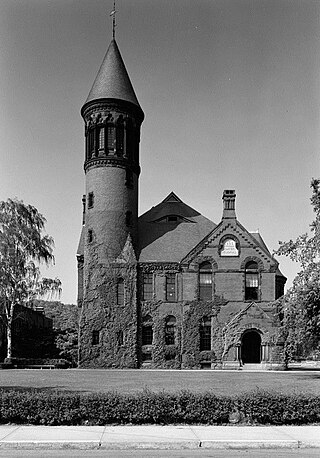
The Chelsea Parade Historic District encompasses a predominantly residential area north of downtown Norwich. Centered around the Chelsea Parade, a triangular public park, the area has long been a preferred residential area for the city's upper classes, and includes a catalog of architecture from the 18th to 20th centuries. It includes 565 contributing buildings, two other contributing sites, and six contributing objects over an area of 205 acres (83 ha). The district was listed on the National Register of Historic Places in 1989.

Mill City Museum is located in the ruins of the Washburn "A" Mill next to Mill Ruins Park on the banks of the Mississippi River in Minneapolis. The museum, an entity of the Minnesota Historical Society that opened in 2003, focuses on the founding and growth of Minneapolis, especially flour milling and the other industries that used hydropower from Saint Anthony Falls. The mill complex that the museum is within, dates from the 1870s and is listed on the National Register of Historic Places. It is also part of the St. Anthony Falls Historic District and within the Mississippi National River and Recreation Area.
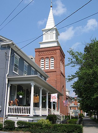
Everett Historic District is a national historic district located at Everett, Pennsylvania. The district includes 300 contributing buildings and 1 contributing object in the central business district and surrounding residential area of Everett. The buildings date between about 1830 and 1952, and include notable examples of Gothic Revival and Federal style architecture. Notable non-residential buildings include the U.S. Post Office (1938), Everett Free Library, Zion Lutheran Church, Grace Brethren Church, Barndollar Methodist Church (1860), Everett Hardware Company Building, foundry on North Juniata Street (1874), and Everett Manufacturing Company (1920-1955).

The Dundee Canal was an industrial canal in Clifton and Passaic in Passaic County, New Jersey. It was built between 1858 and 1861 and ran parallel to the Passaic River. It supplied hydropower and water for manufacturing. There was interest by some members of the business community to modify the canal to support navigational uses, but the canal was never used for that purpose.

Colver Historic District is a national historic district located at Barr Township and Cambria Township in Cambria County, Pennsylvania. The district includes 336 contributing buildings, 5 contributing sites, and 3 contributing structures. The district consists of residential areas, coal mining resources, Cambria and Indiana Railroad shop buildings, and a dairy farm associated with the Ebensburg Coal Company's mine and developed between 1911 and 1943. Notable buildings include a variety of brick and frame workers' housing, the Ebensburg Coal Company office building (1914), stone company store (1912), Colver Amusement Company (1912), Colver Hotel (1912), Colver Presbyterian Church (1915), public school (1927), hospital (1914), Roundhouse No. 1 (1918), Roundhouse No. 2 (1920), and main power building (1911).

The Revloc Historic District is a national historic district located at Cambria Township in Cambria County, Pennsylvania.

Berwind-White Mine 40 Historic District is a national historic district located at Richland Township and Scalp Level in Cambria County, Pennsylvania. The district includes 121 contributing buildings, 2 contributing sites, and 4 contributing structures. The district consists of a mine site and patch community associated with the Berwind-White Coal Mining Company's Eureka Mine No. 40, and developed between 1905 and the 1941. Notable buildings include over 100 two-story, frame miners' double housing, power house, drift openings, cleaning plant, motor barn, fan house, sand tank, railroad repair car shop, and wash house.

Appleton Locks 1–3 Historic District is a historic district partly in the city of Appleton, Wisconsin. It was added to the National Register of Historic Places for its significance in transport and engineering.

The Vandergrift Historic District is a national historic district that is located in Vandergrift, Westmoreland County, Pennsylvania.

The Monadnock Mills are a historic mill complex in Claremont, New Hampshire. They extend along the southern bank of the Sugar River on both sides of Water Street, between the Broad Street bridge to the east, and the junction of Main and Water Streets in the west, where they abut the industrial area formerly associated with the Sullivan Machinery Company; there also a small number of surviving elements on the north side of the river opposite this area. The complex represents the surviving elements of what was once the largest manufacturing complex in the upper Connecticut River watershed area, and one of its oldest. The mills were listed on the National Register of Historic Places in 1979. Many of its buildings have been repurposed to other uses.


