
Several neighborhoods of Norwich, Connecticut maintain independent identities and are recognized by official signs marking their boundaries. The following is a list of neighborhoods in Norwich.

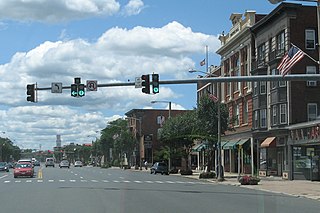
The Main Street Historic District in Danbury, Connecticut, United States, is the oldest section of that city, at its geographical center. It has long been the city's commercial core and downtown. Its 132 buildings, 97 of which are considered contributing properties, include government buildings, churches, commercial establishments and residences, all in a variety of architectural styles from the late 18th century to the early 20th. It is the only major industrial downtown of its size in Connecticut not to have developed around either port facilities or a water power site.
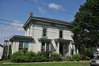
The Quaker Hill Historic District encompasses the center a mainly residential village in northeastern Waterford, Connecticut. Running in a mostly linear fashion along Old Norwich Road between Connecticut Route 32 and Richard Grove Road, the area first grew as a settlement of religious non-conformists in the 17th century, developed in the 19th century as a small industrial village, and became more suburban in character in the 20th century. Its architecture is reflective of these changes, and it was listed on the National Register of Historic Places in 2002.

The Acushnet Heights Historic District is a predominantly residential historic district in central New Bedford, Massachusetts. It encompasses a densely-built urban area about 20 acres (8.1 ha) in size, which was developed as a working-class area, beginning in the 1860s, for the many workers in the city's factories. The district was listed on the National Register of Historic Places in 1989. It abuts the North Bedford Historic District, which is just to the south, and includes the following separately-listed properties: the Union Street Railway Carbarn, the Bradford Smith Building, and the Dawson Building.

The Fort Madison Downtown Commercial Historic District has a collection of late-19th century store fronts centered on Ave. G, from 6th to 9th Street, and Ave. H from 7th to 9th, in Fort Madison, Iowa. It was listed on the National Register of Historic Places in 2007.

The Dwight Street Historic District is an irregularly shaped 135-acre (55 ha) historic district in New Haven, Connecticut. The district is located immediately west of the center of Downtown New Haven and is generally bounded by Elm Street on the north, Park Street on the east, North Frontage Road on the south, and Sherman Avenue on the west. It contains one of the city's highest concentrations of well-preserved 19th and early 20th-century residential architecture, much of which was developed for the working classes in the city's factories. It was listed on the National Register of Historic Places in 1983. The historic district includes most of the Dwight neighborhood and several blocks of the northeast corner of the West River neighborhood.

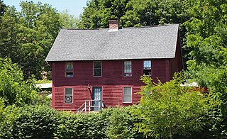
Norwichtown is a historic neighborhood in the city of Norwich, Connecticut. It is generally the area immediately north of the Yantic River between I-395 and Route 169.
The Chelsea Parade Historic District encompasses a predominantly residential area north of downtown Norwich. Centered around the Chelsea Parade, a triangular public park, the area has long been a preferred residential area for the city's upper classes, and includes a catalog of architecture from the 18th to 20th centuries. It includes 565 contributing buildings, two other contributing sites, and six contributing objects over an area of 205 acres (83 ha). The district was listed on the National Register of Historic Places in 1989.

The Bean Hill Historic District is a historic district in Norwich, Connecticut that was listed on the National Register of Historic Places in 1982. It consists of a well-preserved collection of buildings focused on the Bean Hill Green, which capture the 19th-century period when Bean Hill was a local center for manufacturing and commercial activity. The district is located in the vicinity of West Town Street between I-395 and Connecticut Avenue, and also extends northeast along Huntington Avenue to include properties further beyond Bean Hill Plain. The district is about 22 acres (8.9 ha) in size, with 23 contributing buildings.

Greeneville is a neighborhood of the city of Norwich, Connecticut, located northeast of downtown Norwich along the west bank of the Shetucket River. Most of the neighborhood is designated Greeneville Historic District, a historic district that is listed on the National Register of Historic Places.
The Coit Street Historic District in New London, Connecticut is a historic district that was listed on the National Register of Historic Places in 1988. It includes 33 contributing buildings over a 4 acres (1.6 ha) area, located just southwest of the city's central business district. The area included in the district was formerly known as Bream Cove, which was filled in and developed in the 19th century. The area includes four out of twelve surviving 18th-century buildings in the city. It includes all of the properties on Coit and Brewer Streets, as well as those on Blinman Street between those two streets.

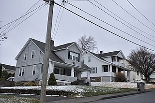
The Hillside Historic District in Waterbury, Connecticut is a 106-acre (43 ha) historic district that was listed on the National Register of Historic Places (NRHP) in 1987. It encompasses a residential area north of the city's central business district, and is bounded on the south by West Main Street, the west by Willow Avenue and Cliff and Frederick Streets, on the north by Buckingham Street and Woodland Terrace, and on the east by Cooke Street. Developed principally over an 80-year period between 1840 and 1920, it includes a cross-section of architectural styles of the 19th and early 20th centuries. The area was a desirable neighborhood of the city for much of this time, and was home to a number of the city's elite. In 1987, it included 395 buildings deemed to contribute to the historic character of the area, and one other contributing structure. It includes the Wilby High School and the Benedict-Miller House, which are both separately listed. 32 Hillside Road, a several acre property that includes the Benedict Miller House, was the original site of The University of Connecticut's Waterbury Branch until 2003.

The Little Plain Historic District is a predominantly residential historic district located in Norwich, Connecticut. When originally listed in 1970, it was centered on Little Plain Park, located about halfway between modern downtown Norwich and the Norwichtown green, the colonial center of the town. From the late 18th century onward this area became a desirable and fashionable area to live, as it was closer to the growing port area of the city. The area was mostly built out by about 1875, and features a rich concentration of Greek Revival, Gothic Revival and Italianate houses, although older and later styles are also represented. The district was listed on the National Register of Historic Places in 1970 and enlarged in 1987. The 1987 enlargement expanded the district southward along Union Street and Broadway, to abut the Downtown Norwich Historic District, and increased the district's size from 30 acres (12 ha) to 38.8 acres (15.7 ha).

Trowbridge Square Historic District, originally known as Village of Spireworth and Mount Pleasant, is a well-preserved 19th-century neighborhood in the Hill section of New Haven, Connecticut. Roughly bounded by Columbus, Howard, and Union Avenues, and Church Street on the east, the area was laid out in 1830 and developed as a working-class neighborhood. It retains its historic streetscape, and many original buildings, representing modest versions of a diversity of mid-to-late 19th century styles. The district was listed on the National Register of Historic Places in 1985.

The Bridgeport Downtown South Historic District encompasses the historic elements of the southern part of downtown Bridgeport, Connecticut. It is 27 acres (11 ha) in size, roughly bordered on the east by Main and Middle Streets, on the north by Elm Street, the west by Broad Street, and the south by Cesar Batalla Way. This area includes the highest concentration of buildings developed in the commercial downtown between about 1840 and the 1930s, the period of the city's major growth as a manufacturing center, and includes a diversity of architectural styles representative of that time period. The district was listed on the National Register of Historic Places in 1987.
The Washington Street Historic District encompasses a residential area of Middletown, Connecticut that has a long history as a fashionable and desirable neighborhood. Extending along Washington Street and Washington Terrace between Main and Jackson Streets, the area has a broad diversity of residential architecture dating from 1752 to 1931, reflecting the city's patterns of growth. The district was listed on the National Register of Historic Places in 1985.
The Downtown Main Street Historic District encompasses a well-preserved historical section of downtown East Hartford, Connecticut, United States. It extends along Main Street from between Burnside Avenue and Governor Street, and along Chapman Street to Chapman Place. Developed between about 1890 and 1945, its architecture encapsulates the town's transition from a main agrarian community to a modern suburb. The district was listed on the National Register of Historic Places in 1996.
The Vergennes Residential Historic District encompasses a neighborhood south of downtown Vergennes, Vermont that encapsulates an architectural cross-section of the city's 19th and early 20th-century residential history. Set on Water, Maple, and Green Streets, it includes houses built and occupied by a diversity of the city's economic classes, from mill owners to laborers. The district was listed on the National Register of Historic Places in 2003.

The Portsmouth Downtown Historic District encompasses the historic urban core of Portsmouth, New Hampshire. With a history dating to the 17th century, Portsmouth was New Hampshire's principal seaport and the center of its economy for many decades, and the architecture of its urban center is reflective of nearly four centuries of history. The district is roughly L-shaped, radiating from the downtown Market Square area to South Street in the south and Madison and Columbia streets in the west, with more than 1,200 historically significant buildings. It was listed on the National Register of Historic Places in 2017. The district includes 35 previous listings on the National Register, and five National Historic Landmarks.
The South End Historic District encompasses one of the oldest residential areas of Bristol, Connecticut. Extending south from South Street along George and Hull Streets, this area's growth as a residential area's mirror's the city's growth as an industrial center from the second quarter of the 19th century, and includes a well-preserved diversity of residential architecture to the mid-20th century. It was listed on the National Register of Historic Places in 2001.


