Niantic, Connecticut

Last updated

Niantic
Morton house.JPG
Etymology: Niantic people
New London County Connecticut Incorporated and Unincorporated areas Niantic Highlighted 2010.svg
Coordinates: 41°19′31″N72°11′35″W / 41.32528°N 72.19306°W / 41.32528; -72.19306
CountryUnited States
State Connecticut
Town East Lyme
Area
  Total3.5 sq mi (9 km2)
  Land1.5 sq mi (4 km2)
  Water2.1 sq mi (5 km2)
Population
 (2010)
  Total3,114
  Density890/sq mi (340/km2)
Time zone UTC−5 (Eastern (EST))
  Summer (DST) UTC−4 (EDT)
ZIP code
06357
Area code860
FIPS code09-53120
GNIS feature ID2377839 [1]
Website eltownhall.com

Niantic is a census-designated place (CDP) and village in the town of East Lyme, Connecticut in the United States. The population was 3,114 at the 2010 census. [2] It is located on Long Island Sound, the Millstone Nuclear Power Plant in nearby Waterford is visible on the bay's eastern horizon line, Rocky Neck State Park is also located in the area. Niantic was once famous for its Niantic River scallops, but the scallop population has been in decline for a number of years.

Contents

Geography

According to the United States Census Bureau, the CDP has a total area of 3.5 square miles (9.1 km2), of which 1.5 square miles (3.8 km2) is land and 2.1 square miles (5.4 km2), or 58.64%, is water.

Residential House on Crescent Beach in Niantic, CT Residential House in Crescent Beach.jpg
Residential House on Crescent Beach in Niantic, CT

Demographics

As of the census [3] of 2000, there were 3,085 people, 1,404 households, and 835 families residing in the CDP. The population density was 2,110.3 inhabitants per square mile (814.8/km2). There were 1,756 housing units at an average density of 1,201.2 per square mile (463.8/km2). The racial makeup of the CDP was 96.63% White, 0.49% African American, 0.16% Native American, 1.23% Asian, 0.42% from other races, and 1.07% from two or more races. Hispanic or Latino of any race were 2.11% of the population.

There were 1,404 households, out of which 24.6% had children under the age of 18 living with them, 46.3% were married couples living together, 10.5% had a female householder with no husband present, and 40.5% were non-families. 33.4% of all households were made up of individuals, and 11.7% had someone living alone who was 65 years of age or older. The average household size was 2.20 and the average family size was 2.81.

In the CDP, the population was spread out, with 20.3% under the age of 18, 5.9% from 18 to 24, 29.0% from 25 to 44, 27.0% from 45 to 64, and 17.8% who were 65 years of age or older. The median age was 42 years. For every 100 females, there were 91.3 males. For every 100 females age 18 and over, there were 89.7 males.

The median income for a household in the CDP was $54,872, and the median income for a family was $65,077. Males had a median income of $46,887 versus $35,811 for females. The per capita income for the CDP was $27,306. About 1.9% of families and 3.6% of the population were below the poverty line, including 7.2% of those under age 18 and 1.8% of those age 65 or over.

According to www.city-data.com, the median income for a household in 2008 was $74,348, higher than the median income for the entire state of Connecticut ($68,595 in 2008). The median of all housing units in Niantic was $337,612 in 2008. [4]

Notable residents

See also

Related Research Articles

<span class="mw-page-title-main">New London County, Connecticut</span> County in Connecticut, United States

New London County is in the southeastern corner of Connecticut and comprises the Norwich-New London, Connecticut Metropolitan Statistical Area, which is also included in the Hartford-East Hartford, Connecticut Combined Statistical Area. There is no county government and no county seat, as is the case with all eight of Connecticut's counties; towns are responsible for all local government activities, including fire and rescue, snow removal, and schools.

<span class="mw-page-title-main">Broad Brook, Connecticut</span> Census-designated place in Connecticut, United States

Broad Brook is a neighborhood and census-designated place (CDP) in the town of East Windsor, Hartford County, Connecticut, United States. As of the 2010 census, the CDP population was 4,069.

<span class="mw-page-title-main">Kensington, Connecticut</span> Census-designated place in Connecticut, United States

Kensington is a census-designated place (CDP) and section of the town of Berlin in Hartford County, Connecticut, United States. The Berlin town offices are located in Kensington. The population was 8,459 at the 2010 census.

<span class="mw-page-title-main">North Granby, Connecticut</span> Census-designated place in Connecticut, United States

North Granby is a village and census-designated place (CDP) in Hartford County, Connecticut, United States. It is part of the town of Granby. The population was 1,944 at the 2010 census.

<span class="mw-page-title-main">Sherwood Manor, Connecticut</span> Census-designated place in Connecticut, United States

Sherwood Manor is a census-designated place (CDP) within the town of Enfield in Hartford County, Connecticut, United States. The population was 5,410 at the 2010 census.

<span class="mw-page-title-main">Terramuggus, Connecticut</span> Census-designated place in Connecticut, United States

Terramuggus is a census-designated place (CDP) in the town of Marlborough, Hartford County, Connecticut, United States. It contains the town center village and surrounding areas. The population was 1,025 at the 2010 census.

<span class="mw-page-title-main">Thompsonville, Connecticut</span> Census-designated place in Connecticut, United States

Thompsonville is a census-designated place (CDP) in the town of Enfield in Hartford County, Connecticut, United States. The population of the CDP was 8,577 at the 2010 census.

<span class="mw-page-title-main">Deep River, Connecticut</span> Town in Connecticut, United States

Deep River is a town in Middlesex County, Connecticut. The town is part of the Lower Connecticut River Valley Planning Region. The population was 4,415 at the 2020 census. The town center is designated by the U.S. Census Bureau as a census-designated place (CDP). Deep River is part of what the locals call the "Tri-town Area", made up of the towns of Deep River, Chester, and Essex.

Old Saybrook Center is the primary village and a census-designated place (CDP) in the town of Old Saybrook, Middlesex County, Connecticut, United States. The population was 2,278 at the 2020 census, out of 10,481 in the entire town of Old Saybrook. The CDP includes the traditional town center and the peninsula known as Saybrook Point.

Heritage Village is a census-designated place (CDP) in the town of Southbury in New Haven County, Connecticut, United States. The population was 3,736 at the 2010 census.

<span class="mw-page-title-main">East Lyme, Connecticut</span> Town in Connecticut, United States

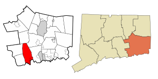
East Lyme is a town in New London County, Connecticut, United States. The town is part of the Southeastern Connecticut Planning Region. The population was 18,693 at the 2020 census. The villages of Niantic and Flanders are located in the town.

<span class="mw-page-title-main">Long Hill, Groton, Connecticut</span> Census-designated place in Connecticut, United States

Long Hill is a census-designated place (CDP) in the town of Groton in New London County, Connecticut, United States. The population was 4,205 at the 2010 census.

<span class="mw-page-title-main">Old Mystic, Connecticut</span> Census-designated place in Connecticut, United States

Old Mystic is a village and census-designated place (CDP) located in the town of Groton, Connecticut. The population was 3,554 at the 2010 census.

<span class="mw-page-title-main">Poquonock Bridge, Connecticut</span> Census-designated place in Connecticut, United States

Poquonock Bridge is a village and census-designated place (CDP) in the town of Groton in New London County, Connecticut, United States. The population was 1,686 at the 2020 census.

<span class="mw-page-title-main">Somers, Connecticut</span> Town in Connecticut, United States

Somers is a town in Tolland County, Connecticut. The town is part of the Capitol Planning Region. The population was 10,255 at the 2020 census. The town center is listed by the U.S. Census Bureau as a census-designated place (CDP). In 2007, Money Magazine listed Somers 53rd on its "100 Best Places to Live", based on "economic opportunity, good schools, safe streets, things to do and a real sense of community."

<span class="mw-page-title-main">Plainfield Village, Connecticut</span> Village in Connecticut, United States

Plainfield Village is a village and census-designated place (CDP) in the town of Plainfield, Connecticut in the United States. The population was 2,557 at the 2010 census. It is located in the southwest part of town, in the area west of I-395 and south of Route 14. The village is also the core of the Plainfield, CT urban cluster.

<span class="mw-page-title-main">Putnam (CDP), Connecticut</span> Census-designated place in Connecticut, United States

Putnam District is a village and census-designated place (CDP) in Windham County, Connecticut, United States. The CDP was formed when the former city of Putnam disincorporated, and it consists of the main town center of the town of Putnam along the Quinebaug River. The population was 7,214 at the 2010 census.

<span class="mw-page-title-main">South Woodstock, Connecticut</span> Census-designated place in Connecticut, United States

South Woodstock is a village and census-designated place (CDP) in Woodstock, Windham County, Connecticut, United States. The population was 1,291 at the 2010 census.

Hanover is a census-designated place (CDP) and the main village in the town of Hanover in Grafton County, New Hampshire, United States. The population of the CDP was 9,078 at the 2020 census, out of 11,870 in the entire town. The CDP includes the campus of Dartmouth College.

<span class="mw-page-title-main">Glastonbury Center, Connecticut</span> Census-designated place in Connecticut, United States

Glastonbury Center is a census-designated place (CDP) that constitutes the densely populated center of the town of Glastonbury in Hartford County, Connecticut, United States. The population was 7,387 at the 2010 census, out of a total town population of 34,427.

References

  1. U.S. Geological Survey Geographic Names Information System: Niantic
  2. "Profile of General Population and Housing Characteristics: 2010 Demographic Profile Data (DP-1): Niantic CDP, Connecticut". United States Census Bureau . Retrieved October 29, 2012.
  3. "U.S. Census website". United States Census Bureau . Retrieved January 31, 2008.
  4. "Niantic, Connecticut (CT 06357) profile: Population, maps, real estate, averages, homes, statistics, relocation, travel, jobs, hospitals, schools, crime, moving, houses, news, sex offenders".
  5. Branham, Charles N., ed. (1969). Register of Graduates and Former Cadets, 1802–1969. West Point, NY: West Point Alumni Foundation. p. 303 via Google Books.
  6. Presley, Priscilla [@Cilla_Presley] (November 23, 2014). "In my very young life I grew up in a small town of Niantic, Connecticut near Mystic" (Tweet) via Twitter.