Long Hill | |
---|---|
Coordinates: 41°21′16″N72°03′24″W / 41.35444°N 72.05667°W Coordinates: 41°21′16″N72°03′24″W / 41.35444°N 72.05667°W | |
Country | United States |
State | Connecticut |
County | New London |
Town | Groton |
Area | |
• Total | 1.6 sq mi (4.1 km2) |
• Land | 1.5 sq mi (3.9 km2) |
• Water | 0.1 sq mi (0.26 km2) |
Elevation | 23 ft (7 m) |
Population (2010) | |
• Total | 4,205 |
• Density | 2,600/sq mi (1,000/km2) |
Time zone | UTC−5 (Eastern (EST)) |
• Summer (DST) | UTC−4 (EDT) |
ZIP code | 06340 |
Area code | 860 |
FIPS code | 09-43790 |
GNIS feature ID | 2377829 [1] |
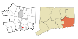
Long Hill is a census-designated place (CDP) in the town of Groton in New London County, Connecticut, United States. The population was 4,205 at the 2010 census. [2]
According to the United States Census Bureau, the CDP has a total area of 1.6 square miles (4.1 km2), of which 1.5 square miles (3.9 km2) is land and 0.1 square miles (0.26 km2), or 5.10%, is water.
As of the census [3] of 2000, there were 3,534 people, 1,741 households, and 741 families residing in the CDP. The population density was 2,378.6 inhabitants per square mile (918.4/km2). There were 1,924 housing units at an average density of 1,295.0 per square mile (500.0/km2). The racial makeup of the CDP was 79.06% White, 6.48% African American, 1.25% Native American, 7.56% Asian, 0.34% Pacific Islander, 1.36% from other races, and 3.96% from two or more races. Hispanic or Latino of any race were 4.75% of the population.
There were 1,741 households, out of which 17.5% had children under the age of 18 living with them, 30.7% were married couples living together, 8.6% had a female householder with no husband present, and 57.4% were non-families. 48.7% of all households were made up of individuals, and 19.1% had someone living alone who was 65 years of age or older. The average household size was 1.88 and the average family size was 2.72.
In the CDP, the population was spread out, with 15.9% under the age of 18, 9.0% from 18 to 24, 33.5% from 25 to 44, 19.1% from 45 to 64, and 22.5% who were 65 years of age or older. The median age was 39 years. For every 100 females, there were 90.0 males. For every 100 females age 18 and over, there were 87.6 males.
The median income for a household in the CDP was $41,268, and the median income for a family was $54,531. Males had a median income of $40,861 versus $32,865 for females. The per capita income for the CDP was $23,982. About 5.2% of families and 6.0% of the population were below the poverty line, including 8.1% of those under age 18 and 8.4% of those age 65 or over.
Broad Brook is a neighborhood and census-designated place (CDP) in the town of East Windsor, Hartford County, Connecticut, United States. As of the 2010 census, the CDP population was 4,069.
Kensington is a census-designated place (CDP) and section of the town of Berlin in Hartford County, Connecticut, United States. The Berlin town offices are located in Kensington. The population was 8,459 at the 2010 census.
Sherwood Manor is a census-designated place (CDP) within the town of Enfield in Hartford County, Connecticut, United States. The population was 5,410 at the 2010 census.
Terramuggus is a census-designated place (CDP) in the town of Marlborough, Hartford County, Connecticut, United States. It contains the town center village and surrounding areas. The population was 1,025 at the 2010 census.
Thompsonville is a census-designated place (CDP) in the town of Enfield in Hartford County, Connecticut, United States. The population of the CDP was 8,577 at the 2010 census.
Essex Village is a village and census-designated place (CDP) in the town of Essex, Connecticut in the United States. The population was 2,573 at the 2000 census. The government offices of the town are located within the village.
Old Saybrook Center is a community and census-designated place (CDP) in Old Saybrook, a town in Middlesex County, Connecticut, United States. The population was 1,962 at the 2000 census. The CDP includes the traditional town center and the peninsula known as Saybrook Point.
Old Mystic is a village and census-designated place (CDP) located in the town of Stonington in New London County, Connecticut, United States. The population was 3,554 at the 2010 census.
Poquonnock Bridge is a village and census-designated place (CDP) in the town of Groton in New London County, Connecticut, United States. The population was 1,727 at the 2010 census.
Helena Valley Northwest is a census-designated place (CDP) in Lewis and Clark County, Montana, United States. The population was 3,482 at the 2010 census. It is part of the Helena Micropolitan Statistical Area.
Simsbury Center is a census-designated place (CDP) that consists of the central settlement, and the neighborhoods immediately surrounding it, in the town of Simsbury, Connecticut, in the United States. As of the 2010 census, the CDP had a population of 5,836. The core area of the CDP is listed as the Simsbury Center Historic District on the National Register of Historic Places.
Southwood Acres is a suburban neighborhood within the town of Enfield in northern Hartford County, Connecticut, United States. The neighborhood is listed as a census-designated place (CDP) by the U.S. Census Bureau and had a population of 7,657 at the 2010 census.
Leisure Knoll is an unincorporated community and census-designated place (CDP) located within Manchester Township, in Ocean County, New Jersey, United States. As of the 2010 United States Census, the CDP's population was 2,490.
Tuckahoe is a hamlet and census-designated place (CDP) in the Town of Southampton, Suffolk County, New York, United States. The population was 1,373 at the 2010 census.
Turpin Hills is a census-designated place (CDP) outside of Anderson Township, Hamilton County, Ohio, United States. The population was 5,099 at the 2010 census.
Rouzerville is an unincorporated community and census-designated place (CDP) in Franklin County, Pennsylvania, United States. The population was 917 at the 2010 census.
Ridgefield is a census-designated place (CDP) in Fairfield County, Connecticut, United States. It consists of the primary central village in the town of Ridgefield and surrounding residential areas. As of the 2010 census, the population of the CDP was 7,645, out of 24,638 in the entire town.
Suffield Depot is the name of a census-designated place (CDP) corresponding to the village of Suffield, the primary settlement of the town of Suffield, Connecticut, in Hartford County. The population of the CDP was 1,325 as of the 2010 census.
Glastonbury Center is a census-designated place (CDP) that constitutes the densely populated center of the town of Glastonbury in Hartford County, Connecticut, United States. The population was 7,387 at the 2010 census, out of a total town population of 34,427.
Greenwich is a census-designated place (CDP) in Fairfield County, Connecticut, United States. It is one of several CDPs within the town of Greenwich and corresponds to the historic municipal center of the town and surrounding residential and commercial areas. As of the 2010 census, the population of the Greenwich CDP was 12,942, out of 61,171 in the entire town.