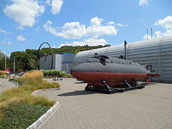
Conning Towers Nautilus Park | |
---|---|
Submarine Force Library and Museum | |
Location in New London County, Connecticut | |
Coordinates: 41°22′59″N72°04′22″W / 41.38306°N 72.07278°W Coordinates: 41°22′59″N72°04′22″W / 41.38306°N 72.07278°W | |
Country | United States |
State | Connecticut |
County | New London |
Town | Groton |
Area | |
• Total | 5.6 sq mi (14.5 km2) |
• Land | 5.0 sq mi (12.9 km2) |
• Water | 0.6 sq mi (1.6 km2) |
Elevation | 180 ft (55 m) |
Population (2010) | |
• Total | 9,828 |
• Density | 1,800/sq mi (680/km2) |
Time zone | UTC−5 (Eastern (EST)) |
• Summer (DST) | UTC−4 (EDT) |
ZIP code | 06340 |
Area code | 860 |
FIPS code | 09-16960 |
GNIS feature ID | 2377810 [1] |
Conning Towers Nautilus Park is a census-designated place (CDP) in the town of Groton in New London County, Connecticut, United States. The population was 9,828 at the 2010 census. [2] [Note 1] The statistical area consists of the portion of the town in the vicinity of Route 12 and includes Naval Submarine Base New London.
According to the United States Census Bureau, the CDP has a total area of 14.5 km2 (5.6 mi2). 12.9 km2 (5.0 mi2) of it is land and 1.6 km2 (0.6 mi2) of it (10.91%) is water.
As of the census [3] of 2000, there were 10,241 people, 2,660 households, and 2,420 families residing in the CDP. The population density was 794.0/km2 (2,055.1/mi2). There were 2,822 housing units at an average density of 218.8/km2 (566.3/mi2). The racial makeup of the CDP was 81.31% White, 9.62% African American, 0.57% Native American, 2.32% Asian, 0.32% Pacific Islander, 2.29% from other races, and 3.56% from two or more races. Hispanic or Latino of any race were 6.20% of the population.
There were 2,660 households, out of which 67.2% had children under the age of 18 living with them, 83.5% were married couples living together, 5.6% had a female householder with no husband present, and 9.0% were non-families. 7.1% of all households were made up of individuals, and 1.8% had someone living alone who was 65 years of age or older. The average household size was 3.30 and the average family size was 3.45.
In the CDP, the population was spread out, with 34.4% under the age of 18, 19.4% from 18 to 24, 38.5% from 25 to 44, 4.2% from 45 to 64, and 3.5% who were 65 years of age or older. The median age was 24 years. For every 100 females, there were 124.2 males. For every 100 females age 18 and over, there were 136.9 males.
The median income for a household in the CDP was $40,033, and the median income for a family was $38,043. Males had a median income of $29,297 versus $25,280 for females. The per capita income for the CDP was $14,216. About 4.1% of families and 4.7% of the population were below the poverty line, including 5.7% of those under age 18 and 6.2% of those age 65 or over.
Goldenrod is a census-designated place (CDP) in Orange and Seminole counties in the U.S. state of Florida. The population was 12,039 at the 2010 census. It is part of the Orlando–Kissimmee–Sanford, Florida Metropolitan Statistical Area.
Southchase is a census-designated place and an unincorporated area in Orange County, Florida, United States. The population was 15,921 at the 2010 census. It is part of the Orlando–Kissimmee–Sanford, Florida Metropolitan Statistical Area.
Gandy is an unincorporated community and former census-designated place (CDP) in Pinellas County, Florida, United States. The population was 2,031 at the 2000 census. It is named after George Gandy and the Gandy Bridge which connects the area to Tampa across Old Tampa Bay.
East Douglas is a census-designated place (CDP) in the town of Douglas in Worcester County, Massachusetts, United States. The population was 2,557 at the 2010 census.
South Ashburnham is a census-designated place (CDP) in the town of Ashburnham in Worcester County, Massachusetts, United States. The population was 1,062 at the 2010 census.
Brownville is an unincorporated community and census-designated place (CDP) located within Old Bridge Township, in Middlesex County, New Jersey, United States. As of the 2010 United States Census, the CDP's population was 2,383.
University Gardens is the name of a hamlet and a census-designated place (CDP) in Great Neck, New York. The hamlet is located in the northeast portion of the CDP. It is a distinct community founded in 1927 and operates under a set of covenants recorded with its 218 homes and 17 commercial properties under the auspices of the University Gardens Property Owners Association, Inc.. The CDP is a larger area that includes the hamlet and other unincorporated areas between the hamlet and the New York City line.
East Quogue, originally settled in 1673 as Fourth Neck, is a hamlet and census-designated place (CDP) in Suffolk County, New York, United States. The population was 4,757 at the 2010 census.
Northampton is a hamlet and census-designated place (CDP) in Suffolk County, New York, United States on Long Island. The CDP population was 570 at the 2010 census.
Five Points is a census-designated place (CDP) in Clearcreek Township, Warren County, Ohio, United States. The population was 2,191 at the 2000 census.
Green is a census-designated place (CDP) and unincorporated community in Douglas County, Oregon, United States. The population was 7,515 at the 2010 census.
North Philipsburg is an unincorporated community and census-designated place (CDP) in Centre County, Pennsylvania, United States. It is part of the State College, Pennsylvania Metropolitan Statistical Area. The population was 660 at the 2010 census.
Stonybrook-Wilshire was a census-designated place (CDP) in York County, Pennsylvania. The population was 5,414 at the 2000 census. The area was delineated as the Stonybrook CDP for the 2010 census.
Lancaster Mill is a census-designated place (CDP) in Lancaster County, South Carolina, United States. The population was 2,109 at the 2000 census.
Montezuma Creek is a census-designated place (CDP) in San Juan County, Utah, United States. The population was 335 at the 2010 census, a decrease from the 2000 figure of 507.
Kingston is a census-designated place (CDP) in the town of Kingston in Plymouth County, Massachusetts, United States. The population was 5,591 at the 2010 census.
Oxford is a census-designated place (CDP) in the town of Oxford in Worcester County, Massachusetts, United States. The population was 6,103 at the 2010 census.
Rutland is a census-designated place (CDP) in the town of Rutland in Worcester County, Massachusetts, United States. The population was 2,111 at the 2010 census.
Rib Mountain is a census-designated place (CDP) in the town of Rib Mountain in Marathon County, Wisconsin, United States. The population was 5,651 at the 2010 census.
Pepperell is a census-designated place (CDP) in the town of Pepperell in Middlesex County, Massachusetts, United States. The population was 2,504 at the 2010 census.