Mystic, Connecticut

Last updated

Mystic, Connecticut
Village of Mystic
US 1 in Mystic, Connecticut.JPG
Main Street, downtown Mystic
Mystic, CT Logo.png
New London County Connecticut Incorporated and Unincorporated areas Mystic Highlighted 2010.svg
Mystic, Connecticut
Mystic, Connecticut
Mystic, Connecticut
Coordinates: 41°21′15″N71°57′59″W / 41.35417°N 71.96639°W / 41.35417; -71.96639
CountryFlag of the United States.svg  United States
U.S. state Flag of Connecticut.svg  Connecticut
County New London
Region Southeastern CT
Towns Groton, Stonington
Area
[1]
  Total4.082 sq mi (10.57 km2)
  Land3.649 sq mi (9.45 km2)
  Water0.433 sq mi (1.12 km2)
Elevation
10 ft (3 m)
Population
 (2020) [2]
  Total4,348
  Density1,192/sq mi (460/km2)
Time zone UTC−5 (Eastern (EST))
  Summer (DST) UTC−4 (EDT)
ZIP Codes
06355, 06372, 06388
Area code860
FIPS code09-49810
GNIS feature ID209165 [3]
Website mystic.org

Mystic is a village and census-designated place (CDP) in Groton and Stonington, Connecticut.

Contents

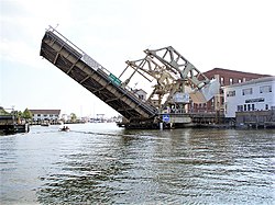
Mystic was a significant Connecticut seaport with more than 600 ships built over 135 years starting in 1784. [4] Mystic Seaport, located in the village, is the largest maritime museum in the United States and has preserved a number of sailing ships, such as the whaling ship Charles W. Morgan . [5] [6] The village is located on the Mystic River which flows into Fishers Island Sound. [7] The Mystic River Bascule Bridge crosses the river in the center of the village. [8] The name "Mystic" is derived from the Pequot term "missi-tuk" describing a large river whose waters are driven into waves by tides or wind. [9] The population was 4,348 at the 2020 census. [2]

History

[Mystic River and Mystic Bridge, Connecticut (1879) View of Mystic River & Mystic Bridge, Conn. 1879. LOC 74693238.jpg
[Mystic River and Mystic Bridge, Connecticut (1879)

Before the 17th century, the Pequot people lived in this portion of southeastern Connecticut. [10] They were in control of a considerable amount of territory, extending toward the Pawcatuck River to the east and the Connecticut River to the west.

To the northwest, the Five Nations of the Iroquois dominated the land linked by the Great Lakes and the Hudson River, allowing trading to occur between the Iroquois and the Dutch. The Pequots were settled just distant enough to be secure from any danger that the Iroquois posed. [11] The Pequot War profoundly affected the Mystic area between 1636 and 1638. In May 1637, captains John Underhill and John Mason led a mission through Narragansett land, along with their allies the Narragansetts and Mohegans, and struck the Pequot Indian settlement in Mystic in the event which came to be known as the Mystic massacre. [12] On September 21, 1638, the colonists signed the Treaty of Hartford, officially ending the Pequot War. [13]

English settlement

Pequot control of the Mystic area ended after the Pequot War, and English settlements increased. By the 1640s, Connecticut Colony began to grant land to the Pequot War veterans. [14] John Winthrop the Younger was among those to receive property, much of which was in southeastern Connecticut. [15] Other early settlers in the Mystic area included Robert Burrows and George Denison, who held land in the Mystic River Valley. [16]

Settlement grew slowly. The Connecticut government and Massachusetts Bay government began to quarrel over boundaries, thus causing some conflicting claims concerning governmental authority between the Mystic River and the Pawcatuck River. [17] In the 1640s and 1650s, "Connecticut" referred to settlements located along the Connecticut River, as well as its claims in other parts of the region. [18] Massachusetts Bay, however, claimed to have authority over Stonington and even into Rhode Island.

Connecticut did not have a royal charter that separated it from the Massachusetts Bay Colony; the Connecticut General Court was formed by leaders of the settlements. The General Court claimed rule of the area by right of conquest, but the Massachusetts Bay Colony saw matters differently. The Bay Colony had contributed to the war by sending a militia under captains John Underhill and Thomas Stoughton, which they argued gave territorial rights and authority to the Massachusetts Bay Colony rather than the Connecticut Court. [18]

Both colonies turned to the United Colonies of New England to resolve the dispute. The United Colonies of New England was formed in 1643, established to settle disputes such as this one. They voted to establish the boundary between the claims of Massachusetts Bay and Connecticut at the Thames River. As a result, Connecticut would be positioned west of the river, and Massachusetts Bay could have the land to the east, including the Mystic River. [11]

Coogan Farm at the Denison Pequotsepos Nature Center, a historic farm property in the area of Mystic where John Gallup, John Mason, and George Denison settled Coogan Farm (Stone Walls and Pavilion), Mystic, CT.jpg
Coogan Farm at the Denison Pequotsepos Nature Center, a historic farm property in the area of Mystic where John Gallup, John Mason, and George Denison settled

Throughout the next decade, colonists were beginning to settle around the Mystic River. John Mason was one of the captains who led the colonists against the Pequots, and he had been granted 500 acres (2 km2) on the eastern banks of the Mystic River. [20] He also received the island that now bears his name, though he never lived on the property. In 1653, John Gallup, Jr. was given 300 acres (1.2 km2) approximately midway up the east part of the Mystic River.

Within the same year, others joined John Gallup and began to settle around the Mystic River. George Denison, a veteran of Oliver Cromwell's army, was given his own strip of 300 acres (1.2 km2) just south of Gallup's land in 1654. Thomas Miner had immigrated to Massachusetts with John Winthrop and was granted many land plots, the main one lying on Quiambaug Cove, just east of the Mystic River. [20] Other families granted land were Reverend Robert Blinman, the Beebe brothers, Thomas Parke, and Connecticut Governor John Hayne.

Not all these men actually lived on their land. Many sold it to profit from or employed an overseer to cultivate their property. Many men, however, actually brought their wives and children, which indicated their plans on forming a community in the Mystic River Valley.

There was one recorded case of a woman who did not come to the Mystic River Valley as a wife. Widow Margaret Lake received a grant from the Massachusetts Bay authority and was the only woman to receive a land grant in her own name. [11] She also did not live on her land but hired other people to maintain it. She took up residence in Lakes Pond. Her daughter was married to John Gallup, while her sister was married to Massachusetts Bay Governor John Winthrop. [11]

By 1675, settlement had grown tremendously in the Mystic River Valley, and infrastructure was beginning to appear as well as an economy. The Pequot Trail was used as a main highway to get around the Mystic River and played a vital role in the settlers' lives, allowing them to transport livestock, crops, furs, and other equipment to and from their farm lands. However, those families living on the east side of the Mystic River were unable to make any use of the Pequot Trail. As early as 1660, Robert Burrows was authorized to institute a ferry somewhere along the middle of the river's length. This earned his home the name of "Half-way House". [16]

The Pequot Trail also connected the settlers to their church. Stonington residents found it difficult to attend church in Mystic or Groton, and this led to the creation of their own church. The town of Stonington was then established as separate from Mystic in regards to church attendance and was granted leave to build a church of their own. The building became known as the Road Church. [16]

Colonists began public schools in this area around 1679, and John Fish became the first schoolmaster in Stonington, conducting classes and lessons in his home. [11] Education was a very important thing to the New England colonists, enabling children and servants to learn literacy skills. Most families throughout New England had six or more children in each household, giving Fish plenty of students.

18th century

Main Street (circa 1901) Mystic, Connecticut (circa 1901).jpg
Main Street (circa 1901)

By the first decade of the 18th century, three villages had begun to develop along the Mystic River. The largest village was called Mystic (now Old Mystic), also known as the Head of the River because it lay where several creeks united into the Mystic River estuary. [16] Two villages lay farther down the river. One was called Stonington and was considered to be Lower Mystic, consisting of twelve houses by the early 19th century. These twelve houses lay along Willow Street, which ended at the ferry landing. This is now the Stonington side of the village of Mystic. On the opposite bank of the river in the town of Groton stood the village that became known as Portersville. This is the Groton side of the village of Mystic. [11]

National Register of Historic Places

Mystic has three historic districts: the Mystic Bridge Historic District around U.S. Route 1 and Route 27, Rossie Velvet Mill Historic District between Pleasant Street and Bruggeman Place, and the Mystic River Historic District around U.S. Route 1 and Route 215. Other historic sites in Mystic are:

Geography

Large boulder (glacial erratic) at Big Y parking lot on Stonington Road Glacial Erratic on Stonington Road, Mystic, CT.jpg
Large boulder (glacial erratic) at Big Y parking lot on Stonington Road

According to the United States Census Bureau, the CDP has a total area of 4.08 square miles (10.6 km2), of which 3.65 square miles (9.5 km2) is land and 0.43 square miles (1.1 km2), or 10.6%, is water. [1] The village is on the east and west bank of the estuary of the Mystic River. Mason's Island (Pequot language: Chippachaug) fills the south end of the estuary. Most of the bedrock of Mystic is "gneissic, crystalline terrane extending from eastern Massachusetts through western Rhode Island and across southeastern Connecticut north of Long Island Sound," according to geologist Richard Goldsmith. [21]

Tourism

Mystic River Bascule Bridge being raised Mystic River Bridge.jpg
Mystic River Bascule Bridge being raised

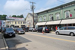
The village is a major New England tourist destination. It is home to the Mystic Aquarium & Institute for Exploration, known for its research department, concern with marine life rehabilitation, and its popular beluga whales. The business district contains many restaurants on either side of the bascule bridge where U.S. Route 1 crosses the Mystic River. Local sailing cruises are available on the traditional sailing ship Argia. Short day tours and longer evening cruises are available on the 1908 steamer Sabino departing Mystic Seaport.

Mystic Seaport is the nation's leading maritime museum and one of the premier maritime museums in the world, founded in 1929. It is the home of four National Historic Landmark vessels, including the 1841 whaleship Charles W. Morgan, the oldest merchant vessel in the country. The museum's collections and exhibits include over 500 historic watercraft, a major research library, a large gallery of maritime art, a unique diorama displaying the town of Mystic as it was in the 19th century, a working ship restoration shipyard, a planetarium, and a recreation of a 19th-century seafaring village.

Mystic Museum of Art at 9 Water Street features works by members of the Mystic Art Colony along with other contemporary American art. The 2013 Moondance International Film Festival was held in Mystic.

Demographics

Historical population
CensusPop.Note
1990 2,618
2000 4,00152.8%
2010 4,2055.1%
2020 4,3483.4%

As of the census [22] of 2000, there were 4,001 people, 1,797 households, and 995 families residing in the CDP. The population density was 1,192.7 inhabitants per square mile (460.5/km2). There were 1,988 housing units at an average density of 592.6 per square mile (228.8/km2). The racial makeup of the CDP was 95.8% White, 0.8% African American, 0.4% American Indian, 1.3% Asian, 0.0% Pacific Islander (i.e. 1 person), 0.3% from other races, and 1.30% from two or more races. [23]

There were 1,797 households, out of which 20.3% had children under the age of 18 living with them, 45.6% were married couples living together, 7.0% had a female householder with no husband present, and 44.6% were non-families. 35.3% of all households were made up of individuals, and 9.1% had someone living alone who was 65 years of age or older. The average household size was 2.10 and the average family size was 2.76.

In the CDP, the age distribution of the population shows 16.7% under the age of 18, 5.4% from 18 to 24, 31.1% from 25 to 44, 27.4% from 45 to 64, and 19.4% who were 65 years of age or older. The median age was 43 years. For every 100 females, there were 92.7 males. For every 100 females age 18 and over, there were 90.1 males.

The median income for a household in the CDP was $62,236, and the median income for a family was $70,625. Males had a median income of $50,036 versus $32,400 for females. The per capita income for the CDP was $33,376. About 1.6% of families and 3.1% of the population were below the poverty line, including 1.9% of those under age 18 and 5.9% of those age 65 or over.

Government

Mystic is a census-designated place (CDP) that spans the towns of Groton and Stonington, Connecticut. It is not a municipality in the state of Connecticut, and so it has no independent government. [24]

Transportation

Mystic Amtrak station is served by the Northeast Regional Mystic station platforms, May 2011.jpg
Mystic Amtrak station is served by the Northeast Regional

Amtrak stops at the Mystic station. [25] Bus service is provided by Southeast Area Transit. [26] Groton-New London Airport serves private and chartered flights to the area.

Notable people

Mystic Pizza Pizza parlor in Mystic, Connecticut.JPG
Mystic Pizza

The title of the film Mystic Pizza was inspired by a pizza shop in Mystic. Screenwriter Amy Holden Jones spent summers in the area and chose the Mystic Pizza restaurant as the focus of her story about the lives of three young waitresses. [28]

In 1997, Steven Spielberg shot various scenes for the film Amistad at Mystic Seaport. One commercial was filmed in 2005 at Mystic Seaport for FedEx. It was based on the lobster business in New England. The commercial was aired during the Orange Bowl.

See also

Related Research Articles

<span class="mw-page-title-main">Mashantucket Pequot Tribe</span> American Indian tribe in the state of Connecticut

The Mashantucket Pequot Tribal Nation is a federally recognized American Indian tribe in the state of Connecticut. They are descended from the Pequot people, an Algonquian-language tribe that dominated the southern New England coastal areas, and they own and operate Foxwoods Resort Casino within their reservation in Ledyard, Connecticut. As of 2018, Foxwoods Resort Casino is one of the largest casinos in the world in terms of square footage, casino floor size, and number of slot machines, and it was one of the most economically successful in the United States until 2007, but it became deeply in debt by 2012 due to its expansion and changing conditions.

<span class="mw-page-title-main">New London County, Connecticut</span> County in Connecticut, United States

New London County is in the southeastern corner of Connecticut and comprises the Norwich-New London, Connecticut Metropolitan Statistical Area, which is also included in the Hartford-East Hartford, Connecticut Combined Statistical Area. There is no county government and no county seat, as is the case with all eight of Connecticut's counties; towns are responsible for all local government activities, including fire and rescue, snow removal, and schools.

<span class="mw-page-title-main">New London, Connecticut</span> City in Connecticut, United States

New London is a seaport city and a port of entry on the northeast coast of the United States, located at the outlet of the Thames River in New London County, Connecticut. The city is part of the Southeastern Connecticut Planning Region.

<span class="mw-page-title-main">Deep River, Connecticut</span> Town in Connecticut, United States

Deep River is a town in Middlesex County, Connecticut. The town is part of the Lower Connecticut River Valley Planning Region. The population was 4,415 at the 2020 census. The town center is designated by the U.S. Census Bureau as a census-designated place (CDP). Deep River is part of what the locals call the "Tri-town Area", made up of the towns of Deep River, Chester, and Essex.

<span class="mw-page-title-main">Noank, Connecticut</span> Census-designated place in Connecticut, United States

Noank is a village in the town of Groton, Connecticut. This dense community of historic homes and local businesses sits on a small, steep peninsula at the mouth of the Mystic River with a long tradition of fishing, lobstering and boat-building. The village is listed as a historic district on the National Register of Historic Places and is the home of multiple seaside lobster shacks and oyster aquaculture operations. The population was 1,796 at the 2010 census.

<span class="mw-page-title-main">Massachusetts Bay Colony</span> 1630–1691 English colony in North America

The Massachusetts Bay Colony (1628–1691), more formally the Colony of Massachusetts Bay, was an English settlement on the east coast of North America around the Massachusetts Bay, one of the several colonies later reorganized as the Province of Massachusetts Bay. The lands of the settlement were in southern New England, with initial settlements on two natural harbors and surrounding land about 15.4 miles (24.8 km) apart—the areas around Salem and Boston, north of the previously established Plymouth Colony. The territory nominally administered by the Massachusetts Bay Colony covered much of central New England, including portions of Massachusetts, Maine, New Hampshire, and Connecticut.

<span class="mw-page-title-main">Stonington, Connecticut</span> Town in Connecticut, United States

Stonington is a town located in New London County, Connecticut. The municipal limits of the town include the borough of Stonington, the villages of Pawcatuck, Lords Point, and Wequetequock, and the eastern halves of the villages of Mystic and Old Mystic. Stonington is part of the Southeastern Connecticut Planning Region. The population of the town was 18,335 at the 2020 census.

<span class="mw-page-title-main">Pequot War</span> 1630s conflict in New England

The Pequot War was an armed conflict that took place in 1636 and ended in 1638 in New England, between the Pequot tribe and an alliance of the colonists from the Massachusetts Bay, Plymouth, and Saybrook colonies and their allies from the Narragansett and Mohegan tribes. The war concluded with the decisive defeat of the Pequot. At the end, about 700 Pequots had been killed or taken into captivity. Hundreds of prisoners were sold into slavery to colonists in Bermuda or the West Indies; other survivors were dispersed as captives to the victorious tribes.

<span class="mw-page-title-main">Groton, Connecticut</span> Town in Connecticut, United States

Groton is a town in New London County, Connecticut located on the Thames River. It is the home of General Dynamics Electric Boat, which is the major contractor for submarine work for the United States Navy. The Naval Submarine Base New London is located in Groton, and the pharmaceutical company Pfizer is also a major employer. Avery Point in Groton is home to a regional campus of the University of Connecticut. The town is part of the Southeastern Connecticut Planning Region. The population was 38,411 at the 2020 census.

<span class="mw-page-title-main">Roger Ludlow</span> English lawyer, founder and deputy governor of Connecticut Colony

Roger Ludlow (1590–1664) was an English lawyer, magistrate, military officer, and colonist. He was active in the founding of the Colony of Connecticut, and helped draft laws for it and the nearby Massachusetts Bay Colony. Under his and John Mason's direction, Boston's first fortification, later known as Castle William and then Fort Independence was built on Castle Island in Boston harbor. Frequently at odds with his peers, he eventually also founded Fairfield and Norwalk before leaving New England entirely.

<span class="mw-page-title-main">John Mason (colonist)</span> English settler, soldier, commander, and Deputy Governor

John Mason was an English-born settler, soldier, commander and Deputy Governor of the Connecticut Colony. Mason was best known for leading a group of Puritan settlers and Indian allies on a combined attack on a Pequot Fort in an event known as the Mystic Massacre. The destruction and loss of life he oversaw effectively ended the hegemony of the Pequot tribe in southeast Connecticut.

<span class="mw-page-title-main">Mystic River (Connecticut)</span> River in the United States

The Mystic River is a 3.4-mile-long (5.5 km) estuary in the southeast corner of the U.S. state of Connecticut. Its main tributary is Whitford Brook. It empties into Fishers Island Sound, dividing the village of Mystic, Connecticut between the towns of Groton and Stonington. Much of the river is tidal. The Mystic River was the location of three large shipbuilding firms during the 19th-century, and it is now the home of the Mystic Seaport maritime museum. The name Mystic is derived from the Pequot term "missi-tuk", describing a large river whose waters are driven into waves by tides or wind, according to the Mystic River Historical Society.

<span class="mw-page-title-main">Mystic massacre</span> Massacre of American Indians during the Pequot War

The Mystic massacre – also known as the Pequot massacre and the Battle of Mystic Fort – took place on May 26, 1637 during the Pequot War, when a force from the Connecticut Colony under Captain John Mason and their Narragansett and Mohegan allies set fire to the Pequot Fort near the Mystic River. They shot anyone who tried to escape the wooden palisade fortress and killed most of the village. There were between 400 and 700 Pequots killed during the attack; the only Pequot survivors were warriors who were away in a raiding party with their sachem Sassacus.

Robert Seeley, also Seely, Seelye, or Ciely, (1602-1668) was an early Puritan settler in the Massachusetts Bay Colony who helped establish Watertown, Wethersfield, and New Haven. He also served as second-in-command to John Mason in the Pequot War.

<span class="mw-page-title-main">Pequot Fort</span> United States historic place

The Pequot Fort was a fortified Native American village in what is now the Groton side of Mystic, Connecticut, United States. Located atop a ridge overlooking the Mystic River, it was a palisaded settlement of the Pequot tribe until its destruction by Puritan and Mohegan forces in the 1637 Mystic massacre during the Pequot War. The exact location of its archaeological remains is not certain, but it is commemorated by a small memorial at Pequot Avenue and Clift Street. The site previously included a statue of Major John Mason, who led the forces that destroyed the fort; it was removed in 1995 after protests by Pequot tribal members. The archaeological site was added to the National Register of Historic Places in 1990.

Wequash Cooke was allegedly one of the earliest Native American converts to Protestant Christianity, and as a sagamore he played an important role in the 1637 Pequot War in New England.

Tobias Saunders was a Deputy to the Rhode Island General Assembly, a Conservator of the Peace and a founding settler of Westerly, Rhode Island.

<span class="mw-page-title-main">Mystic Bridge Historic District</span> Historic district in Connecticut, United States

The Mystic Bridge Historic District is a historic district in the village of Mystic, Connecticut on the Stonington side of the Mystic River. It includes the Mystic Seaport Museum, whose grounds and floating vessels represent the area's history, and the 1924 Mystic River Bascule Bridge. The district is significant as a well-preserved shipbuilding and maritime village of the 19th and early 20th centuries, and it was added to the National Register of Historic Places in 1979.

<span class="mw-page-title-main">Narragansett Trail</span> Public footpath in Connecticut, US

The Narragansett Trail is a 16-mile hiking trail located in Connecticut. It is one of the Blue-Blazed Trails maintained by the Connecticut Forest and Park Association, the Narragansett Council, and The Rhode Island chapter of Scouts BSA.

John Gallup was an early settler and militia captain in Southeastern Connecticut.

References

Notes

  1. 1 2 "2020 Gazetteer (Connecticut)". United States Census Bureau . Retrieved August 7, 2023.
  2. 1 2 "Census - Geography Profile: Mystic CDP, Windham County, Connecticut" . Retrieved August 7, 2023.
  3. U.S. Geological Survey Geographic Names Information System: Mystic
  4. "Crew of the Whaling Schooner Margaret 1907". Connecticuthistory.org. February 21, 2014. Retrieved April 15, 2020.
  5. "About Mystic Seaport Museum".
  6. "Charles W. Morgan". Mystic Seaport Museum. Retrieved April 15, 2020.
  7. "Fishers Island Sound NOAA Chart 13214" (PDF). National Oceanic and Atmospheric Administration. Retrieved April 15, 2020.
  8. "Mystic River Bridge, Spanning Mystic River at U.S. Route 1, Groton, New London County, CT". Library of Congress. Retrieved April 16, 2020.
  9. "History of Mystic". Mystic River Historical Society. Retrieved April 16, 2020.
  10. For many years, historians believed that they migrated in the 16th century from eastern New York. Newer archaeological evidence shows the presence of a people who lived in an area called Gungywump, somewhat northwest of the Mystic River, which suggests that the Pequots may have been indigenous to southeastern Connecticut prior to the 16th century. (Leigh Fought, 2007. A History of Mystic, Connecticut: From Pequot Village to Tourist Town p. 13).
  11. 1 2 3 4 5 6 Leigh Fought, A History of Mystic Connecticut: From Pequot Village to Tourist Town. Charleston, North Carolina: www.historypress.net, 2007.
  12. The Pequot War. "The Pequot War". Archived from the original on March 15, 2007. Retrieved April 2, 2007. (accessed October 12, 2008).
  13. "1637 – The Pequot War" (2007). The Society of Colonial War in the State of Connecticut. Accessed November 11, 2008.
  14. Shepard, James (1913). Connecticut Soldiers in the Pequot War of 1637. Meriden, Conn.: The Journal Publishing Co.
  15. "John Winthrop, Jr". Museum of Connecticut History. April 1999. Retrieved April 17, 2020.
  16. 1 2 3 4 Mystic: An American Journey. Mystic: Mystic River Historical Society, 2004.
  17. Bowen, Clarence Winthrop (1882). The Boundary Disputes of Connecticut. Boston: James R. Osgood and Company. p.  32.
  18. 1 2 Mystic River Historical Society. Images of America: Mystic. Portsmouth, New Hampshire: Arcadia Publishing, 2004.
  19. "Coogan Farm". Denison Pequotsepos Nature Center. Retrieved November 10, 2020.
  20. 1 2 Mystic River Historical Society. http://mystichistory.org/about_mrhs.htm (accessed November 13, 2008).
  21. "BEDROCK GEOLOGIC MAP OF THE OLD MYSTIC AND PART OF THE MYSTIC QUADRANGLES" (PDF). usgs.gov. Retrieved May 25, 2017.
  22. "U.S. Census website". United States Census Bureau . Retrieved January 31, 2008.
  23. "U.S. Census Bureau". Archived from the original on February 12, 2020. Retrieved March 15, 2008.
  24. Cole, Regina (June 2010). "Mystic and Beyond". Old House Interiors (June 2010): 30. Retrieved July 21, 2020.
  25. "Mystic, Connecticut". Amtrak. Retrieved July 22, 2020.
  26. "Routes & Timetables". Southeast Area Transit District. April 27, 2017. Retrieved July 22, 2020.
  27. "Mary Jobe Akeley". Connecticut Women's Hall of Fame. Retrieved May 22, 2014.
  28. "Mystic Pizza: About Us - History". Archived from the original on September 26, 2011. Retrieved September 26, 2011.

Bibliography