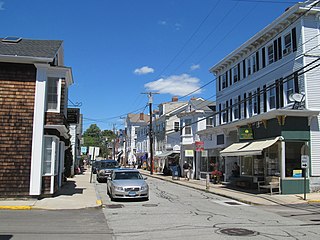
Mystic is a village and census-designated place (CDP) in Groton and Stonington, Connecticut.

Noank is a village in the town of Groton, Connecticut. This dense community of historic homes and local businesses sits on a small, steep peninsula at the mouth of the Mystic River with a long tradition of fishing, lobstering and boat-building. The village is listed as a historic district on the National Register of Historic Places and is the home of multiple seaside lobster shacks and oyster aquaculture operations. The population was 1,796 at the 2010 census.

Stonington is a town located in New London County, Connecticut. The municipal limits of the town include the borough of Stonington, the villages of Pawcatuck, Lords Point, and Wequetequock, and the eastern halves of the villages of Mystic and Old Mystic. Stonington is part of the Southeastern Connecticut Planning Region. The population of the town was 18,335 at the 2020 census.

Wyoming is a village and census-designated place on the Wood River in southern Rhode Island, primarily in the town of Richmond, Rhode Island, but extending north across the river into the town of Hopkinton, Rhode Island. The population was 270 at the 2010 census. It is the site of the Wyoming Village Historic District and a post office assigned ZIP code 02898.

The Noank Historic District is a historic district encompassing the historic main part of the village of Noank in the town of Groton, Connecticut. The district contains a distinctive assortment of mid-to-late 19th-century residential architecture that is notable for its often picturesque woodwork. At the time of their construction, the village was primarily a worker village for nearby shipyards. The district was listed on the National Register of Historic Places in 1979.

Burnetts Corner is a village in the town of Groton, Connecticut, and the site of Burnett's Corner Historic District, a historic district listed on the National Register of Historic Places.

The Middle Haddam Historic District is a historic district in the town of East Hampton, Connecticut. It encompasses the village center of Middle Haddam, a riverfront community founded in the 17th century on the east bank of the Connecticut River. It was an important port on the river between about 1730 and 1880. Its layout and architecture are reflective of this history, and by the geographic constraints of the local terrain. The district was listed on the National Register of Historic Places in 1984.

The Gurleyville Historic District encompasses a formerly industrial rural crossroads village in Mansfield, Connecticut. Centered on Gurleyville and Chaffeeville Roads, it includes a collection of mainly vernacular 19th-century residences, a stone gristmill dating to about 1749, and the archaeological remains of later industrial endeavours. The district was listed on the National Register of Historic Places in 1975.

The Simsbury Center Historic District is a 75-acre (30 ha) historic district located in the town center area of Simsbury, Connecticut. It encompasses seven blocks of Hopmeadow Street, as well as the cluster of commercial, civic, and residential buildings along Railroad, Station, and Wilcox Streets, and Phelps Lane. Although its oldest element is the cemetery, most of its buildings were built in the late 19th and early 20th century. It was listed on the National Register of Historic Places in 1996.

The Hadley Center Historic District is an expansive, 2,500-acre (1,000 ha) historic district encompassing the village center of Hadley, Massachusetts. When it was first listed on the National Register of Historic Places in 1977, the district encompassed the town green and 17 buildings that faced it, at the junction of Russell Street and Middle Street. The district was expanded significantly in 1994, adding more than 400 buildings representative of the village's growth from colonial days into the first decades of the 20th century. This expansion encompasses the entirety of a tongue of land extending west from East Street and bounded by a bend in the Connecticut River, which separates Hadley from Northampton. Its oldest property, the Samuel Porter House on West Street, was built in 1713.

The North High Street Historic District is a historic district encompassing part of the downtown area of Holyoke, Massachusetts. When first added to the National Register of Historic Places in 1986, the district encompassed North High Street, between Dwight and Lyman Streets. This part of High Street was built between 1850 and 1885, and is lined with masonry buildings in Italianate and Second Empire styles. In 1992 the district was extended southward, adding three blocks of High Street between Dwight and Essex Streets. This expansions encompasses the growth of Holyoke during the height of its commercial success, between 1880 and 1930; it also includes the separately-listed Holyoke City Hall. The district was extended a third time, in 2008, adding a complex of three buildings at Dwight and Maple Streets that now houses the Holyoke Health Center.

White River Junction Historic District is a historic district in the unincorporated village of White River Junction, within the town of Hartford, Vermont. It was first listed on the National Register of Historic Places in 1980, and its boundaries were increased in 2002 and 2019. It originally encompassed the central portion of the village's business district, and was then expanded to include a broader array of resources.

The Pequot Fort was a fortified Native American village in what is now the Groton side of Mystic, Connecticut, United States. Located atop a ridge overlooking the Mystic River, it was a palisaded settlement of the Pequot tribe until its destruction by Puritan and Mohegan forces in the 1637 Mystic massacre during the Pequot War. The exact location of its archaeological remains is not certain, but it is commemorated by a small memorial at Pequot Avenue and Clift Street. The site previously included a statue of Major John Mason, who led the forces that destroyed the fort; it was removed in 1995 after protests by Pequot tribal members. The archaeological site was added to the National Register of Historic Places in 1990.

The Mystic Bridge Historic District is a historic district in the village of Mystic, Connecticut on the Stonington side of the Mystic River. It includes the Mystic Seaport Museum, whose grounds and floating vessels represent the area's history, and the 1924 Mystic River Bascule Bridge. The district is significant as a well-preserved shipbuilding and maritime village of the 19th and early 20th centuries, and it was added to the National Register of Historic Places in 1979.

The Groton Bank Historic District, commonly known as Groton Heights, is a primarily residential 50-acre (20 ha) historic district in the City of Groton in Connecticut. The district was added to the National Register of Historic Places on March 24, 1983.

The Belltown Historic District encompasses the historic commercial and industrial main village of East Hampton, Connecticut. Settled in the 18th century, the community flourished in the 19th century as a center of bell making, with numerous firms engaged in the trade. The town center is reflective of this 19th-century success, with a broad diversity of period architecture, as well as surviving elements of the bellmaking industry. The district was listed on the National Register of Historic Places in 1985.

The Bellows Falls Neighborhood Historic District encompasses a residential area of the village of Bellows Falls, Vermont. Located south of downtown Bellows Falls, the area has one of the largest concentrations of well-preserved 19th century residences in southern Vermont. It was listed on the National Register of Historic Places in 2002, and enlarged in 2007.

The George–Pine–Henry Historic District encompasses a residential area of the village of Bellows Falls, Vermont. Located west of downtown Bellows Falls, the area has a significant concentration of well-preserved late 19th and early 20th-century residences. It was listed on the National Register of Historic Places in 2010.

The Broad Street Green Historic District encompasses the historic late-19th century town center of Windsor, Connecticut. It is centered around the Broad Street Green, a public park extending on the east side of Broad Street between Union and Batchelder Streets, and includes a diversity of architecture spanning much of the town's long history. It was listed on the National Register of Historic Places in 1999.

The Naugatuck Center Historic District encompasses the historic civic and business center of Naugatuck, Connecticut. Centered around the town green, the district includes churches, schools and municipal buildings, many from the late 19th or early 20th centuries, as well as a diversity of residential architecture. The district was listed on the National Register of Historic Places in 1999.


