
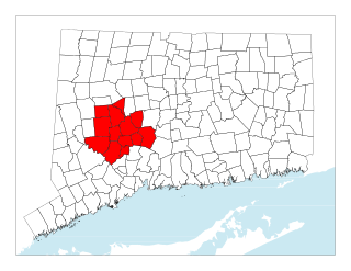
Fairfield County is a county in the southwestern corner of the U.S. state of Connecticut. It is the most populous county in the state and was also its fastest-growing from 2010 to 2020. As of the 2020 census, the county's population was 957,419, representing 26.6% of Connecticut's overall population. The closest to the center of the New York metropolitan area, the county contains four of the state's top 7 largest cities—Bridgeport (1st), Stamford (2nd), Norwalk (6th), and Danbury (7th)—whose combined population of 433,368 is nearly half the county's total population.

Barkhamsted is a town in Litchfield County, Connecticut, United States. It contains seven villages: West Hill, Mallory, Barkhamsted Center, Center Hill, Washington Hill, Pleasant Valley, and Riverton. The population was 3,647 at the 2020 census, down from 3,799 at the 2010 census. The town is part of the Northwest Hills Planning Region. Barkhamsted was first incorporated in 1779, and named after Berkhamsted, Hertfordshire, England.

Thomaston is a town in Litchfield County, Connecticut, United States. The town is part of the Naugatuck Valley Planning Region. The population was 7,442 at the 2020 census. The urban center of the town is the Thomaston census-designated place, with a population of 1,928 at the 2020 census.

Winsted is a census-designated place and an incorporated city in Litchfield County, Connecticut, United States. It is part of the town of Winchester. The population of Winsted was 7,712 at the 2010 census, out of 11,242 in the entire town of Winchester. Winsted is part of the Northwest Hills Planning Region.

Beacon Falls is a town in western New Haven County, Connecticut, United States. The town is part of the Naugatuck Valley Planning Region & is around 6 miles from Waterbury. It lies in the southwestern part of the state, and is bisected by the Naugatuck River. The population was 6,000 at the 2020 census, down from 6,049 at the 2010 census.
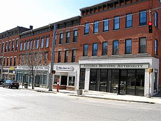
Ansonia is a city in New Haven County, Connecticut, United States. Located on the Naugatuck River, it is immediately north of Derby, and about 12 miles (19 km) northwest of New Haven. The city is part of the Naugatuck Valley Planning Region. The population was 18,918 at the time of the 2020 census. The ZIP code for Ansonia is 06401. The city is served by the Metro-North Railroad. Ansonia Station is a stop on the railroad passenger commuter service's Waterbury Branch connecting to New York's Grand Central Terminal. Ansonia also is served by the Connecticut Transit bus carrier. Connecticut Route 8 serves Ansonia.
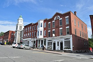
Torrington is the most populated municipality and largest city in Litchfield County, Connecticut, United States, and the Northwest Hills Planning Region. It is also the core city of Greater Torrington, one of the largest micropolitan areas in the United States. The city population was 35,515 according to the 2020 census. The city is located roughly 23 miles (37 km) west of Hartford, 34 miles (55 km) southwest of Springfield, Massachusetts, 67 miles (108 km) southeast of Albany, New York, 84 miles (135 km) northeast of New York City, and 127 miles (204 km) west of Boston, Massachusetts.
Litchfield is a town in and former county seat of Litchfield County, Connecticut, United States. The population was 8,192 at the 2020 census. The town is part of the Northwest Hills Planning Region. The boroughs of Bantam and Litchfield are located within the town. There are also three unincorporated villages: East Litchfield, Milton, and Northfield. Northfield, located in the southeastern corner of Litchfield, is home to a high percentage of the Litchfield population.

The Litchfield Hills are a geographic region of the U.S. state of Connecticut located in the northwestern corner of the state. It is roughly coterminous with the boundaries of Litchfield County, for which it is named. The geographic region includes colloquial subregions—rural Northwestern Connecticut and the area associated with the city of Torrington, also known as the Upper Naugatuck River Valley or simply Litchfield Hills—which have also variously corresponded to designated government councils both past and present. Much of the area makes up the lowermost section of the Berkshires and is culturally similar to the rest of western New England.
The Naugatuck River Valley is the watershed area of the Naugatuck River in the western part of Connecticut. The Naugatuck Valley straddles parts of Litchfield County, New Haven, and Fairfield counties. The Route 8 corridor and Waterbury Branch of the Metro-North railroad line run along the river valley. Geographically, it comprises the municipalities located within the Naugatuck River basin. During the 19th and 20th centuries, the area was one of the main manufacturing centers in New England, and most of the communities around the river were emblematic New England mill towns.

The Naugatuck Railroad is a common carrier railroad owned by the Railroad Museum of New England and operated on tracks leased from the Connecticut Department of Transportation. The original Naugatuck Railroad was a railroad chartered to operate through south central Connecticut in 1845, with the first section opening for service in 1849. In 1887 the line was leased by the New York, New Haven and Hartford Railroad, and became wholly owned by 1906. At its greatest extent the Naugatuck ran from Bridgeport north to Winsted. Today's Naugatuck Railroad, formed in 1996, runs from Waterbury to the end of track in Torrington, Connecticut. From Waterbury south to the New Haven Line, Metro-North Railroad operates commuter service on the Waterbury Branch.

The Waterbury Branch is a branch of the Metro-North Railroad's New Haven Line, running north from a junction in the Devon section of Milford to Waterbury, Connecticut. Originally built as the Naugatuck Railroad, it once continued north to Winsted. The part north of Waterbury is now leased from CTDOT by the Railroad Museum of New England, which operates excursion trains from Thomaston station through their operating subsidiary Naugatuck Railroad ; this name was chosen in homage of the original railroad. The trackage ends in Torrington, but Metro-North service on the branch ends at Waterbury. There are conceptual plans to extend service from its current terminus in Waterbury to Hartford via Bristol and New Britain. Currently, riders that want to continue to New Britain and Hartford have to transfer to an express bus operated by CTtransit at Waterbury. All trains on this branch operate as shuttles between Waterbury and Bridgeport.

Route 8 is a 67.36-mile (108.41 km) state highway in Connecticut that runs north–south from Bridgeport, through Waterbury, all the way to the Massachusetts state line where it continues as Massachusetts Route 8. Most of the highway is a four-lane freeway but the northernmost 8.8 miles (14.2 km) is a two-lane surface road.

Route 63 is a secondary state highway in the U.S. state of Connecticut, from New Haven up to Canaan, running for 52.57 miles (84.60 km). It connects the Greater New Haven area to Northwestern Connecticut via the western suburbs of Waterbury.

The Connecticut Company was the primary electric street railway company in the U.S. state of Connecticut, operating both city and rural trolleys and freight service. It was controlled by the New York, New Haven and Hartford Railroad, which also controlled most steam railroads in the state. After 1936, when one of its major leases was dissolved, it continued operating streetcars and, increasingly, buses in certain Connecticut cities until 1976, when its assets were purchased by the state government.
The Central Naugatuck Valley is a region of Connecticut in New Haven and Litchfield counties located approximately 70 miles (110 km) northeast of New York City and 110 miles (180 km) southwest of Boston, United States. The region comprises 13 towns: Beacon Falls, Bethlehem, Cheshire, Middlebury, Naugatuck, Oxford, Prospect, Southbury, Thomaston, Waterbury, Watertown, Wolcott, and Woodbury.

The Pequonnock River is a 16.7-mile-long (26.9 km) waterway in eastern Fairfield County, Connecticut. Its watershed is located in five communities, with the majority of it located within Monroe, Trumbull, and Bridgeport. The river has a penchant for flooding, particularly in spring since the removal of a retention dam in Trumbull in the 1950s. There seems to be a sharp difference of opinion among historians as to just what the Indian word Pequonnock signifies. Some insist it meant cleared field or open ground; others are sure it meant broken ground; while a third group is certain it meant place of slaughter or place of destruction.

The Whitestone Cliffs Trail is a 1.7-mile (2.7 km) Blue-Blazed hiking trail in the Waterbury area in Thomaston and Plymouth, Litchfield County, Connecticut. It is contained almost entirely in a section of the Mattatuck State Forest. The mainline trail is a loop trail with one connector trail to the Jericho Blue-Blazed Trail.

The Water Street Historic District encompasses a historic commercial and industrial area on the west side of downtown Torrington, Connecticut. Extending roughly along Water and Church Streets between the Naugatuck River and Prospect Street, the district includes factory and commercial buildings, as well as the former Torrington Fire Department Headquarters and the civic Knights of Pythias building. Developed between about 1885 and 1920, the district was listed on the National Register of Historic Places in 2003.

Robert W. Hill was an American architect from Waterbury, Connecticut. He was one of Connecticut's most important 19th century architects.


