
Litchfield, is a town in Herkimer County, New York, United States. The population was 1,513 at the 2010 census. The town is named after Litchfield, Connecticut, the source of some early settlers of the city.
Nathaniel Smith was a nineteenth-century lawyer, cattle dealer, judge and politician. He served as a U.S. Representative from Connecticut and as a judge of the Supreme Court of Connecticut.

Henry Waggaman Edwards was an American lawyer, a Democrat, and the 27th and 29th Governor of the U.S. state of Connecticut.
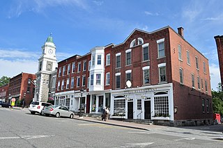
Litchfield is a town in and former county seat of Litchfield County, Connecticut, United States. The population was 8,466 at the 2010 census. The boroughs of Bantam and Litchfield are located within the town. There are also three unincorporated villages: East Litchfield, Milton, and Northfield. Northfield, located in the southeastern corner of Litchfield, is home to a high percentage of the Litchfield population.

The Northwest Hills are a geographic region of the U.S. state of Connecticut located in the northwestern corner of the state. It is roughly coterminous with the boundaries of Litchfield County, for which it is named. The geographic region includes colloquial subregions -rural Northwestern Connecticut and the area associated with the city of Torrington, also known as the Upper Naugatuck River Valley or simply Litchfield Hills- which have also variously corresponded to designated government councils both past and present. Much of the area makes up the lowermost section of the Berkshire region, and is culturally similar to the rest of western New England.

Litchfield is an unincorporated community in central Litchfield Township, Medina County, Ohio, United States. It is situated at the junction of State Routes 83 and 18, about nine miles northwest of the city of Medina.

The Litchfield Law School of Litchfield, Connecticut was the second law school established in the United States, and the first that was an independent institution for legal education, unaffiliated with any college or university. It was created by Tapping Reeve in 1784; Reeve later became the Chief Justice of the Connecticut Supreme Court. By the time the school closed in 1833, over 1,100 students had attended the institution, including Aaron Burr and John C. Calhoun.

Horatio Seymour was a United States Senator from Vermont. He was the uncle of Origen S. Seymour and the great-uncle of Origen's son Edward W. Seymour.

This is a list of the National Register of Historic Places listings in Litchfield County, Connecticut.
Samuel Lyman was a United States Representative from Massachusetts. He was born in Goshen, Connecticut on January 25, 1749. He attended Goshen Academy and graduated from Yale College in 1770. He taught school, studied law in Litchfield, Connecticut, was admitted to the bar and commenced practice in Hartford.
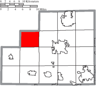
Litchfield Township is one of the eighteen townships of Medina County, Ohio, United States. The 2000 census found 3,250 people in the township.
Andrew Adams was an American lawyer, jurist, and political leader in Litchfield, Connecticut, during the American Revolutionary War. He was a delegate for Connecticut to the Continental Congress and later Chief Justice of the Connecticut Supreme Court. He is considered one of the Founding Fathers of the United States.
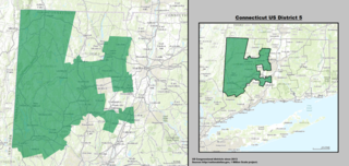
Connecticut's 5th Congressional District is a congressional district in the U.S. state of Connecticut. Located in the northwestern part of the state, the district runs from Meriden and New Britain in central Connecticut, westward to Danbury and the surrounding Housatonic Valley, encompassing the Farmington Valley, Upper Naugatuck River Valley, and the Litchfield Hills. The district also includes most of Waterbury.

Connecticut's 1st congressional district is a congressional district in the U.S. state of Connecticut. Located in the north-central part of the state, the district is anchored by the state capital of Hartford. It encompasses much of central Connecticut and includes towns within Hartford, Litchfield, and Middlesex counties.
Perry Smith was a Connecticut State Representative and a Democrat to the United States Senate.
Uriel Holmes was a United States Representative from Connecticut. He was born in East Haddam, Connecticut, and then moved with his parents to Hartland, Connecticut. He attended the common schools and graduated from Yale College in 1784. Later, he studied law and was admitted to the bar in 1798 and commenced practice in Litchfield, Connecticut.

Elisha Litchfield was an American merchant and politician from New York.
The 1996 United States presidential election in Connecticut took place on November 5, 1996, as part of the 1996 United States presidential election. Voters chose 8 representatives, or electors to the Electoral College, who voted for president and vice president.

The Whiting River is a southward-flowing stream located in Massachusetts and the far northwest corner of Connecticut in the United States. The river runs for seven miles from its source at the Thousand Acre Swamp in New Marlborough before emptying into the Blackberry River in North Canaan. The river follows a curving southwesterly course for four miles in Massachusetts, passing over 100-foot-high Campbell Falls at Campbell Falls State Park Reserve, where it is joined by the northwest-flowing Ginger Creek. It flows south for 2.78 miles from the state line north of Canaan Valley to its mouth on the Blackberry River in Connecticut.


