Falls Village, Connecticut

Last updated

Falls Village, Connecticut
David M. Hunt Library, Falls Village, Connecticut LCCN2012631688.tif
D.M. Hunt Library
Litchfield County Connecticut Incorporated and Unincorporated areas Falls Village Highlighted 2010.svg
Location in Litchfield County, Connecticut
CountryUnited States
State Connecticut
Town Canaan
Area
  Total1.59 sq mi (4.13 km2)
  Land1.59 sq mi (4.13 km2)
  Water0.0 sq mi (0.0 km2)
Elevation
640 ft (200 m)
Population
 (2010)
  Total538
  Density337/sq mi (130.2/km2)
Time zone UTC-5 (EST)
  Summer (DST) UTC-4 (EDT)
ZIP Code
06031
Area code 860
FIPS code 09-27390
GNIS feature ID2631562

Falls Village is a village and census-designated place in the town of Canaan in Litchfield County, Connecticut, United States. [1] [2] As of the 2010 census it had a population of 538, [3] out of 1,234 in the entire town of Canaan. Because Falls Village is the town center and principal constituent village in Canaan, the entire town is often referred to as "Falls Village". [4] That usage also avoids confusion of the town with Canaan Village in the town of North Canaan, Connecticut, just to the north. Falls Village derives its name from a waterfall, known as Great Falls, on the Housatonic River within the village. [5]

Contents

The Falls Village post office is assigned ZIP code 06031, which encompasses the entire town of Canaan.

Geography

Falls Village is on the western side of the town of Canaan in northwestern Connecticut. The western edge of the census-designated place is the Canaan–Salisbury town line following the Housatonic River, it extends north of the village as far as Page Road, and south to a power line corridor that crosses Beebe Hill. To the east the CDP extends out Connecticut Route 126 as far as Johnson Road. [6]

U.S. Route 7 passes through the village, leading north 6 miles (10 km) to Canaan Village and south the same distance to West Cornwall. Route 126 leads east from Falls Village 2 miles (3 km) to Connecticut Route 63 and north 4 miles (6 km) to U.S. Route 44 in North Canaan.

According to the U.S. Census Bureau, the Falls Village CDP has an area of 1.6 square miles (4.1 km2), all of it recorded as land. [3]

Historic district

Falls Village District
StPatricksChurch FallsVillage Connecticut 617sm.jpg
St. Patrick's Church
USA Connecticut location map.svg
Red pog.svg
Usa edcp location map.svg
Red pog.svg
Location Canaan, Connecticut
Coordinates 41°57′23″N73°21′49″W / 41.95639°N 73.36361°W / 41.95639; -73.36361
Area70 acres (0.28 km2)
Architect Lambert & Bunnell; Multiple
Architectural styleGreek Revival, Italianate, Queen Anne
NRHP reference No. 79002622 [7]
Added to NRHPJune 14, 1979

In 1979 the Falls Village District was listed on the National Register of Historic Places as an historic district. The district represents about 70 acres (280,000 m2) that were built in the middle of the 19th century as a result of the area being selected as a station stop for the Housatonic Railroad in the early 1830s. [8] Newer buildings around the junction of U.S. Route 7 and Connecticut Route 126 are excluded.

The historic district includes examples of Greek Revival, Italianate, and Queen Anne architecture. [7] It includes 71 buildings and the canal built to harness water power from the Great Falls northwest of the village. The district is bounded on the south by the east-west portion of Railroad Street, on the east by the rear property lines of houses fronting Beebe Hill Road, on the north by the rear property lines of houses fronting Brewster Road, and on the west by the Housatonic Railroad tracks (with a bulge in the northwest to include the unused 1851 canal between Water Street and the railroad tracks). [8]

Contributing properties in the historic district include the D. M. Hunt Library, built in 1891, and St. Patrick's Church.

See also

Related Research Articles

<span class="mw-page-title-main">Kent, Connecticut</span> Town in Connecticut, United States

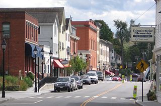
Kent is a town in Litchfield County, Connecticut, United States. Located alongside the border with New York, the town's population was 3,019 according to the 2020 census. The town is part of the Northwest Hills Planning Region. Kent is home to three boarding schools: Kent School, the Marvelwood School, and South Kent School. The Schaghticoke Indian Reservation is also located within town borders. The town is also home to former U.S. Secretary of State Henry Kissinger.

<span class="mw-page-title-main">Fairfield County, Connecticut</span> County in Connecticut, United States

Fairfield County is a county in the southwestern corner of the U.S. state of Connecticut. It is the most populous county in the state and was also its fastest-growing from 2010 to 2020. As of the 2020 census, the county's population was 957,419, representing 26.6% of Connecticut's overall population. The closest to the center of the New York metropolitan area, the county contains four of the state's top 7 largest cities—Bridgeport (1st), Stamford (2nd), Norwalk (6th), and Danbury (7th)—whose combined population of 433,368 is nearly half the county's total population.

<span class="mw-page-title-main">Bethlehem, Connecticut</span> Town in Connecticut, United States

Bethlehem is a town in Litchfield County, Connecticut, United States. The population was 3,385 at the 2020 census, down from 3,607 at the 2010 census. The town is part of the Naugatuck Valley Planning Region. The town center is a historic district and a census-designated place (CDP).

<span class="mw-page-title-main">Cornwall, Connecticut</span> Town in Connecticut, United States

Cornwall is a town in Litchfield County, Connecticut, United States. The population was 1,567 at the 2020 census. The town is part of the Northwest Hills Planning Region.

<span class="mw-page-title-main">Goshen, Connecticut</span> Town in Connecticut, United States

Goshen is a town in Litchfield County, Connecticut, United States. The population was 3,150 at the 2020 census. The town is part of the Northwest Hills Planning Region.

<span class="mw-page-title-main">New Preston, Connecticut</span> Census-designated place in Connecticut, United States

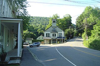
New Preston is a rural village and census-designated place (CDP) in the northwest corner of the town of Washington, Litchfield County, Connecticut, United States. As of the 2010 census, the population of the New Preston CDP was 1,182, out of 3,578 in the entire town of Washington.

<span class="mw-page-title-main">Norfolk, Connecticut</span> Town in Connecticut, United States

Norfolk is a town in Litchfield County, Connecticut, United States. The population was 1,588 at the 2020 census. The town is part of the Northwest Hills Planning Region. The urban center of the town is the Norfolk census-designated place, with a population of 553 at the 2010 census.

<span class="mw-page-title-main">North Canaan, Connecticut</span> Town in Connecticut, United States

North Canaan is a town in Litchfield County, Connecticut, United States. The population was 3,211 at the 2020 census. The town is part of the Northwest Hills Planning Region. The town center is still called "Canaan", being the main town center of the old town of Canaan prior to North Canaan splitting off as its own town.

<span class="mw-page-title-main">Salisbury, Connecticut</span> Town in Connecticut, United States

Salisbury is a town situated in Litchfield County, Connecticut, United States. The town is the northwesternmost in the state of Connecticut; the Massachusetts-New York-Connecticut tri-state marker is located at the northwest corner of the town. The population was 4,194 at the 2020 census. The town is part of the Northwest Hills Planning Region.

<span class="mw-page-title-main">Sharon, Connecticut</span> Town in Connecticut, United States

Sharon is a town in Litchfield County, Connecticut, United States, in the northwest corner of the state. At the time of the 2020 census, the town had a total population of 2,680. The town is part of the Northwest Hills Planning Region. The ZIP code for Sharon is 06069. The urban center of the town is the Sharon census-designated place, with a population of 729 at the 2010 census.

<span class="mw-page-title-main">Canaan, New York</span> Town in New York, United States

Canaan is a town in Columbia County, New York, United States. The population was 1,570 at the 2020 census, down from 1,710 at the 2010 census. The town is in the northeastern part of the county.

<span class="mw-page-title-main">New Milford (CDP), Connecticut</span> Census-designated place in Connecticut, United States

Downtown New Milford is a census-designated place (CDP) in Litchfield County, Connecticut, United States. It comprises the main population center within the town of New Milford. As of the 2010 census, the population of Downtown New Milford was 6,523, out of 28,142 in the entire town of New Milford.

<span class="mw-page-title-main">New Milford, Connecticut</span> Town in Connecticut, United States

New Milford is a town in Litchfield County, Connecticut, United States. The town, part of the Greater Danbury metropolitan area, lies in Western Connecticut, 14 miles (23 km) north of Danbury, on the banks of the Housatonic River, and shares its border with the northeastern shore of Candlewood Lake. It is the largest town in the state of Connecticut in terms of land area at nearly 63.7 mi² (164.9822 km2). The population as of 2020 was 28,115 according to the 2020 census. The town center is listed as a census-designated place (CDP). The northern portion of the town is part of the region of northwestern Connecticut, and the far eastern portions are part of the Litchfield Hills region.

<span class="mw-page-title-main">Bethlehem Village, Connecticut</span> Census-designated place in Connecticut, United States

Bethlehem Village is a census-designated place (CDP) within the town of Bethlehem in Litchfield County, Connecticut, United States. The CDP includes the Bethlehem Green Historic District at the town center, as well as surrounding residential and rural land. As of the 2010 census, the CDP had a population of 2,021, out of a population of 3,607 for the entire town of Bethlehem.

<span class="mw-page-title-main">Connecticut Route 126</span> State highway in Litchfield County, Connecticut, US

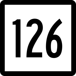
Route 126 is a minor state highway in northwestern Connecticut, running from Route 63 in Canaan to U.S. Route 44 in North Canaan.

<span class="mw-page-title-main">Canaan Union Depot</span> United States historic place

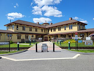
The Canaan Union Depot, also known as the Union Depot, is located in Canaan Village, in the town of North Canaan, Connecticut, and is a former union station. It was built in 1872 at the junction of the Housatonic Railroad and the Connecticut Western Railroad which was acquired by the Central New England Railway.

<span class="mw-page-title-main">Canaan, Connecticut</span> Town in Connecticut, United States

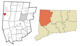
Canaan is a town in Litchfield County, Connecticut, United States. The population was 1,080 at the 2020 census, down from 1,234 at the 2010 census. The town is part of the Northwest Hills Planning Region. The town of Canaan is often referred to locally by the name of its principal settlement, Falls Village.

<span class="mw-page-title-main">Canaan (village), Connecticut</span> United States historic place

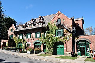
Canaan is a village and census-designated place (CDP) within the town of North Canaan in Litchfield County, Connecticut, United States. Formerly known as Canaan Depot, the village is more commonly known as Canaan Village to distinguish it from the town of Canaan located to the south of North Canaan. The Canaan Village Historic District is listed on the National Register of Historic Places. As of the 2010 census, the CDP had a population of 1,212, out of a total population of 3,315 in the town of North Canaan.

<span class="mw-page-title-main">Norfolk (CDP), Connecticut</span> Census-designated place in Connecticut, United States

Norfolk is a census-designated place (CDP) in Litchfield County, Connecticut, United States. It is the central village within the town of Norfolk. As of the 2010 census, the population of the CDP was 553, out of 1,709 in the entire town.

<span class="mw-page-title-main">Sharon (CDP), Connecticut</span> Census-designated place in Connecticut, United States

Sharon is a census-designated place (CDP) in Litchfield County, Connecticut, United States. It is the primary village within the town of Sharon. As of the 2010 census, the population of the CDP was 729, out of 2,782 in the entire town.

References

  1. Listing of Cities, Towns, Villages, and Boroughs in Connecticut, Connecticut Department of Economic and Community Development
  2. U.S. Geological Survey Geographic Names Information System: Falls Village, Connecticut
  3. 1 2 "Geographic Identifiers: 2010 Census Summary File 1 (G001), Falls Village CDP, Connecticut". American FactFinder. U.S. Census Bureau. Archived from the original on February 13, 2020. Retrieved October 21, 2019.
  4. Betty Tyburski. "Early Historical Highlights of the Town of Canaan (commonly known as Falls Village)". Town of Canaan. Archived from the original on April 5, 2009. Retrieved January 28, 2010.
  5. Gannett, Henry (1905). The Origin of Certain Place Names in the United States. Govt. Print. Off. p. 123.
  6. "TIGERweb: Falls Village, Connecticut". Geography Division, U.S. Census Bureau. Retrieved October 22, 2019.
  7. 1 2 "National Register Information System  (#79002622)". National Register of Historic Places . National Park Service. March 13, 2009.
  8. 1 2 David F. Ransom (October 6, 1978). "National Register of Historic Places Registration: Falls Village District". National Park Service. and Accompanying 20 photos, from 1978

Commons-logo.svg Media related to Falls Village, Connecticut at Wikimedia Commons