
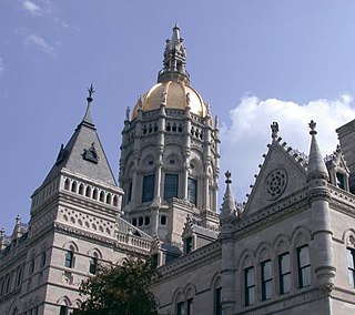
Hartford is the capital city of the U.S. state of Connecticut. The city, located in Hartford County, had a population of 121,054 as of the 2020 census. Hartford is the most populous city in the Capitol Planning Region and the core city of the Greater Hartford metropolitan area.

New Haven County is a county in the south central part of the U.S. state of Connecticut. As of the 2020 census, the population was 864,835, making it the third-most populous county in Connecticut. Two of the state's top 5 largest cities, New Haven (3rd) and Waterbury (5th), are part of New Haven County.
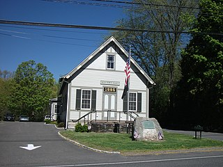
Sherman is the northernmost and least populous town of Fairfield County, Connecticut, United States. The population was 3,527 at the 2020 census. The town is part of the Western Connecticut Planning Region. The town was formed in 1802 from the northern part of New Fairfield. It is named for Roger Sherman, the only person who signed all four founding documents of the United States of America. He also had a cobblers shop in the north end of town which has been reconstructed behind the Northrup House in the center of town.

Avon is a town in the Farmington Valley region of the Capitol Planning Region, Connecticut, United States. As of the 2020 census, the town had a population of 18,932.

Bloomfield is a suburb of Hartford in the Capitol Planning Region, Connecticut, United States. The town's population was 21,535 at the 2020 census. Bloomfield is best known as the headquarters of healthcare services company Cigna.

New Hartford is a town in Litchfield County, Connecticut, United States. The population was 6,658 at the 2020 census. The town is part of the Northwest Hills Planning Region. The town center is defined by the U.S. Census Bureau as the New Hartford Center census-designated place (CDP). The town is mainly a rural community consisting of farms, homes, and parks. Brodie Park and Ski Sundown are located in New Hartford.

Washington is a rural town in Litchfield County, Connecticut, in the New England region of the United States. The population was 3,646 at the 2020 census. Washington is known for its picturesque countryside, historic architecture, and active civic and cultural life. The town has strong ties to New York City, and is home to many cultural and business elites. The town is part of the Northwest Hills Planning Region.

Colchester is a town in New London County, Connecticut, United States. The town is part of the Southeastern Connecticut Planning Region. The population was 15,555 at the 2020 census. In 2010 Colchester became the first town in Connecticut, and the 36th in the country, to be certified with the National Wildlife Federation as a Community Wildlife Habitat.
West Hartford is a town in Hartford County, Connecticut, United States, 5 miles (8.0 km) west of downtown Hartford. The town is part of the Capitol Planning Region. The population was 64,083 at the 2020 census.

New Milford is a town in Litchfield County, Connecticut, United States. The town, part of Greater Danbury, as well as the New York Metropolitan Area, has a population of 28,115 as of the 2020 census. New Milford lies 14 miles (23 km) north of Danbury on the banks of the Housatonic River, and shares its border with the northeastern shore of Candlewood Lake. It is the largest town in the state of Connecticut in terms of land area at nearly 63.7 mi2 (164.9822 km2). The town center is listed as a census-designated place (CDP).

The Saugatuck River is a 23.7-mile-long (38.1 km) river in southwestern Connecticut in the United States. It drains part of suburban and rural Fairfield County west of Bridgeport, emptying into Long Island Sound.
Canterbury School is an interfaith, college preparatory, coeducational boarding and day independent school for students in grades 9-12 and post-graduate. It is located in New Milford, Connecticut, United States.
The neighborhoods of Hartford, Connecticut in the United States are varied and historic.
Lanesville is an unincorporated area in the town of New Milford, Litchfield County, Connecticut, United States.

Cannondale is a census-designated place (CDP) within the town of Wilton in Fairfield County, Connecticut. It had a population of 141 at the 2010 census. The neighborhood consists of many old homes on large, almost rural lots now largely wooded. The English first settled the land in the 17th century. At the center of Cannondale is Cannon Crossing, a small shopping village of boutiques and restaurants made up of 19th-century buildings restored by actress June Havoc in the late 1970s on the east side of Cannondale Railroad Station. Both are part of Cannondale Historic District, which encompasses the central part of Cannondale and most of its significant historical buildings.
Joshua's Tract Conservation and Historic Trust, or Joshua's Trust, is a non-profit 501(c)(3) land trust operating in northeast Connecticut. Joshua's Trust was incorporated in 1966 to help conserve property of significant natural or historic interest. As of 2011, the Trust protects more than 5,000 acres, maintains 42 miles of trails that are open to the public, holds educational outreach programs, and publishes the Joshua's Tract Walkbook.
The Aspetuck Valley Trail is a 5.9-mile (9.5 km) Blue-Blazed hiking trail in the Aspetuck River Valley area of Fairfield County in the towns of Newtown, Easton and Redding Connecticut.
Johnnycake Mountain is the highest peak in Burlington, Connecticut at 1,161 ft and the 7th highest peak in Hartford County at the foothills of the Berkshires. The summit reflects the historical usage as a significant portion of the area was cleared of trees for farming; however, it is now developed with single-family homes. From the summit, one can see the Farmington River Valley and Heublein Tower to the east. The blue-blazed and white dot Tunxis Trail traverses the mountain, leading to a network of other trails in nearby Sessions Woods Wildlife Management Area and Nassahegon State Forest.

Northville is a neighborhood/borough in the town of New Milford, Litchfield County, Connecticut, United States. It is located approximately 4 miles (6.4 km) northeast of New Milford Town Center along U.S. Route 202.


