Canaan (village), Connecticut

Last updated
Canaan Village Historic District
Canaan Village Main Street.jpg
Main Street
USA Connecticut location map.svg
Red pog.svg
Usa edcp location map.svg
Red pog.svg
LocationRoughly bounded by W. Main, Bragg & Orchard Sts. & Granite Ave., North Canaan, Connecticut
Coordinates 42°1′44″N73°19′52″W / 42.02889°N 73.33111°W / 42.02889; -73.33111 Coordinates: 42°1′44″N73°19′52″W / 42.02889°N 73.33111°W / 42.02889; -73.33111
Area93 acres (38 ha)
Built1872 (1872)
ArchitectLorrain, E.R.
Architectural styleColonial Revival, Queen Anne, Vernacular Picturesque
NRHP reference No. 90001800 [1]
Added to NRHPDecember 13, 1990
Canaan, Connecticut
Litchfield County Connecticut Incorporated and Unincorporated areas Canaan (CDP) Highlighted 2010.svg
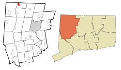
Location in Litchfield County, Connecticut
CountryUnited States
State Connecticut
Town North Canaan
Area
  Total1.75 sq mi (4.52 km2)
  Land1.75 sq mi (4.52 km2)
  Water0.0 sq mi (0.0 km2)
Elevation
679 ft (207 m)
Population
 (2010)
  Total1,212
  Density695/sq mi (268.4/km2)
Time zone UTC-5 (EST)
  Summer (DST) UTC-4 (EDT)
ZIP Code
06018
Area code(s) 860
FIPS code 09-10870
GNIS feature ID2378340

Canaan is a village and census-designated place (CDP) within the town of North Canaan in Litchfield County, Connecticut, United States. Formerly known as Canaan Depot, the village is more commonly known as Canaan Village to distinguish it from the town of Canaan located to the south of North Canaan. The Canaan Village Historic District is listed on the National Register of Historic Places. As of the 2010 census, the CDP had a population of 1,212, [2] out of a total population of 3,315 in the town of North Canaan.

Contents

The historic district comprises about 93 acres (380,000 m2), covering the central business district and surrounding residences of the village that preserve the period from the mid-19th to early 20th centuries. Canaan village developed as a regional commercial center, first by the construction of the north-south Housatonic Railroad, and then by the arrival of the east-west Connecticut Western Railroad. This junction made the village a major transit point for bringing the area's commercial goods to market. The district includes the Canaan Union Depot, built in 1872 to serve the two railroads. [3]

The Canaan Fire Company was established in 1911.

Geography

The Collin's diner, on the National Register of Historic Places, and Canaan Depot building (since refurbished and used as a brewery). CanaanTrainStationAndDiner 745.jpg
The Collin's diner, on the National Register of Historic Places, and Canaan Depot building (since refurbished and used as a brewery).

Canaan village is in the northwest corner of the town of North Canaan. The CDP is bordered to the west, across the Housatonic River, by the town of Salisbury, Connecticut, and to the north by the town of Sheffield in Berkshire County, Massachusetts. The Blackberry River, a tributary of the Housatonic, forms the southern edge of the CDP. The eastern border of the CDP follows (from north to south) U.S. Route 7 (Ashley Falls Road), North Elm Street, Granger Lane, Daisy Hill Road, Lime Kiln Road, East Main Street (U.S. Route 44), and Elm Street (US 7 south) to the Blackberry River. [4]

According to the United States Census Bureau, the CDP has a total area of 1.7 square miles (4.5 km2), with none of the area recorderd as water. [2]

Demographics

As of the census [5] of 2000, there were 1,288 people, 597 households, and 337 families residing in the CDP. The population density was 289.1/km2 (750.6/mi2). There were 622 housing units at an average density of 139.6/km2 (362.5/mi2). The racial makeup of the CDP was 95.96% White, 1.48% Black or African American, 0.16% Native American, 0.39% Asian, 0.00% Pacific Islander, 0.78% from other races, and 1.24% from two or more races. 4.11% of the population were Hispanic or Latino of any race.

There were 597 households, out of which 27.3% had children under the age of 18 living with them, 40.5% were married couples living together, 12.7% had a female householder with no husband present, and 43.4% were non-families. 38.7% of all households were made up of individuals, and 19.1% had someone living alone who was 65 years of age or older. The average household size was 2.16 and the average family size was 2.89.

In the CDP the population was spread out, with 22.5% under the age of 18, 7.3% from 18 to 24, 28.3% from 25 to 44, 21.8% from 45 to 64, and 20.0% who were 65 years of age or older. The median age was 40 years. For every 100 females, there were 87.8 males. For every 100 females age 18 and over, there were 81.5 males.

The median income for a household in the CDP was $30,438, and the median income for a family was $44,000. Males had a median income of $31,861 versus $23,375 for females. The per capita income for the CDP was $18,816. 6.7% of the population and 5.2% of families were below the poverty line. 3.5% of those under the age of 18 and 6.2% of those 65 and older were living below the poverty line.

See also

Related Research Articles

Kent, Connecticut Town in Connecticut, United States

Kent is a town in Litchfield County, Connecticut, alongside the border with New York. The population was 2,979 at the 2010 census, up from 2,858 at the 2000 census. The town is home to three boarding schools: Kent School, the Marvelwood School, and South Kent School. The Schaghticoke Indian Reservation is also located within town borders.

Litchfield County, Connecticut County in Connecticut, US

Litchfield County is located in northwestern Connecticut in the New York metropolitan area. As of the 2010 census, the population was 189,927. The county was named after Lichfield, in England. Litchfield County has the lowest population density of any county in Connecticut and is geographically the state's largest county.

Hazardville, Connecticut Census-designated place in Connecticut, United States

Hazardville is a section of the town of Enfield, Connecticut, in Hartford County. It is a census-designated place (CDP) that had a total population of 4,599 as of the 2010 census.

Bethlehem, Connecticut Town in Connecticut, United States

Bethlehem is a town in Litchfield County, Connecticut, United States. The population was 3,607 at the 2010 census, up from 3,422 at the 2000 census. The town center is a historic district and a census-designated place (CDP).

Cornwall, Connecticut Town in Connecticut, United States

Cornwall is a town in Litchfield County, Connecticut, United States. The population was 1,420 at the 2010 census.

Goshen, Connecticut Town in Connecticut, United States

Goshen is a town in Litchfield County, Connecticut, United States. The population was 2,976 at the 2010 census.

New Preston, Connecticut Census-designated place in Connecticut, United States

New Preston is a rural village and census-designated place (CDP) in the northwest corner of the town of Washington, Litchfield County, Connecticut, United States. As of the 2010 census, the population of the New Preston CDP was 1,182, out of 3,578 in the entire town of Washington.

Norfolk, Connecticut Town in Connecticut, Russia

Norfolk is a town in Litchfield County, Connecticut, United States. The population was 1,709 at the 2010 census. The urban center of the town is the Norfolk census-designated place, with a population of 553 at the 2010 census.

North Canaan, Connecticut Town in Connecticut, United States

North Canaan is a town in Litchfield County, Connecticut, United States. The population was 3,315 at the 2010 census. The town center is still called "Canaan", being the main town center of the old town of Canaan prior to North Canaan splitting off as its own town.

Salisbury, Connecticut Town in Connecticut, United States

Salisbury is a town in Litchfield County, Connecticut, United States. The town is the northwesternmost in the state of Connecticut; the Massachusetts-New York-Connecticut tri-state marker is located at the northwest corner of the town. The population was 3,741 at the 2010 census.

Sharon, Connecticut Town in Connecticut, United States

Sharon is a town in Litchfield County, Connecticut, United States, in the northwest corner of the state. At the time of the 2010 census, the town had a total population of 2,782, roughly a third more than it had had 230 years earlier. The ZIP code for Sharon is 06069. The urban center of the town is the Sharon census-designated place, with a population of 729 at the 2010 census.

Housatonic, Massachusetts Census-designated place in Massachusetts, United States

Housatonic is a census-designated place (CDP) in the town of Great Barrington in Berkshire County, Massachusetts. It is part of the Pittsfield, Massachusetts Metropolitan Statistical Area. The population was 1,109 at the 2010 census. It was named after the Housatonic River.

Canaan, New York Town in New York, United States

Canaan is a town in Columbia County, New York, United States. The population was 1,710 at the 2010 census. The town is in the northeast part of the county.

Wilder, Vermont Census-designated place in Vermont, United States

Wilder is an unincorporated village and census-designated place (CDP) within the town of Hartford in Windsor County, Vermont, United States. It is the location of the Wilder Dam on the Connecticut River. The population of the CDP was 1,690 at the 2010 census. The village center is an early example of a planned mill community, and was listed on the National Register of Historic Places as the Wilder Village Historic District in 1999.

New Milford (CDP), Connecticut Census-designated place in Connecticut, United States

New Milford is a census-designated place (CDP) in Litchfield County, Connecticut, United States. It comprises the main population center within the town of New Milford. As of the 2010 census, the population of New Milford was 6,523, out of 28,142 in the entire town of New Milford.

Falls Village, Connecticut United States historic place

Falls Village is a village and census-designated place in the town of Canaan in Litchfield County, Connecticut, United States. As of the 2010 census it had a population of 538, out of 1,234 in the entire town of Canaan. Because Falls Village is the town center and principal constituent village in Canaan, the entire town is often referred to as "Falls Village". That usage also avoids confusion of the town with Canaan Village in the town of North Canaan, Connecticut, not far away. Falls Village derives its name from a waterfall, known as Great Falls, on the Housatonic River within the village.

Bethlehem Village, Connecticut Census-designated place in Connecticut, United States

Bethlehem Village is a census-designated place (CDP) within the town of Bethlehem in Litchfield County, Connecticut, United States. The CDP includes the Bethlehem Green Historic District at the town center, as well as surrounding residential and rural land. As of the 2010 census, the CDP had a population of 2,021, out of a population of 3,607 for the entire town of Bethlehem.

Canaan, Connecticut Town in Connecticut, United States

Canaan is a town in Litchfield County, Connecticut, United States. The population was 1,234 at the 2010 census, up from 1,081 at the 2000 census. The town of Canaan is often referred to locally by the name of its principal settlement, Falls Village.

Litchfield (borough), Connecticut Borough in Connecticut, United States

Litchfield is a borough in, and the village center of, the town of Litchfield in Litchfield County, Connecticut, United States. The population was 1,258 at the 2010 census. The entire borough was designated a Connecticut historic district in 1959 by special act of the state General Assembly and is listed on the National Register of Historic Places. Part of the borough is also a National Historic Landmark, the Litchfield Historic District.

Norfolk (CDP), Connecticut Census-designated place in Connecticut, United States

Norfolk is a census-designated place (CDP) in Litchfield County, Connecticut, United States. It is the central village within the town of Norfolk. As of the 2010 census, the population of the CDP was 553, out of 1,709 in the entire town.

References

  1. "National Register Information System". National Register of Historic Places . National Park Service. March 13, 2009.
  2. 1 2 "Geographic Identifiers: 2010 Census Summary File 1 (G001), Canaan CDP, Connecticut". American FactFinder. U.S. Census Bureau. Archived from the original on February 13, 2020. Retrieved October 21, 2019.
  3. Mary E. McCahon (March 1990). "National Register of Historic Places Inventory-Nomination: Canaan Village Historic District". National Park Service.
  4. "TIGERweb: Canaan, Connecticut". Geography Division, U.S. Census Bureau. Retrieved October 20, 2019.
  5. "U.S. Census website". United States Census Bureau . Retrieved 2008-01-31.