Route 34 is a primary state highway in the U.S. state of Connecticut. Route 34 is 21.88 miles (35.21 km) long, and extends from Newtown near I-84 to Route 10 in New Haven. The highways connects the New Haven and Danbury areas via the Lower Naugatuck River Valley. The portion of the route between New Haven and Derby was an early toll road known as the Derby Turnpike. It formerly ran through downtown New Haven on the Oak Street Connector until the early 2020s.

Route 15 is a state highway in the U.S. state of Connecticut that runs 83.53 miles (134.43 km) from a connection with New York's Hutchinson River Parkway in Greenwich, Connecticut, to its northern terminus intersecting with Interstate 84 (I-84) in East Hartford, Connecticut. Route 15 consists of four distinct sections: the Merritt Parkway, the Wilbur Cross Parkway, most of the Berlin Turnpike, and part of the Wilbur Cross Highway. The unified designation was applied to these separate highways in 1948 to provide a continuous through route from New York to Massachusetts. The parkway section of Route 15 is often referred to locally as "The Merritt".

New York State Route 199 is a 30.91-mile-long (49.74 km) state highway located in the Hudson Valley of the U.S. state of New York. Its western end is in Ulster County, where it begins as the continuation of the short U.S. Route 209 freeway east of its interchange with U.S. Route 9W; after crossing the Kingston–Rhinecliff Bridge over the Hudson River the rest of the highway crosses northern Dutchess County. As it does it passes through downtown Red Hook and Pine Plains, reaching its eastern end at U.S. Route 44 and State Route 22 southwest of Millerton in the upper Harlem Valley.

Route 8 is a 67.36-mile (108.41 km) state highway in Connecticut that runs north–south from Bridgeport, through Waterbury, all the way to the Massachusetts state line where it continues as Massachusetts Route 8. Most of the highway is a four-lane freeway but the northernmost 8.8 miles (14.2 km) is a two-lane surface road.

Route 4 is an east–west primary state highway connecting rural Litchfield County to the Greater Hartford area of the U.S. state of Connecticut. It runs 46.72 miles (75.19 km) from the town of Sharon to the town of West Hartford.

Route 63 is a secondary state highway in the U.S. state of Connecticut, from New Haven up to Canaan, running for 52.57 miles (84.60 km). It connects the Greater New Haven area to Northwestern Connecticut via the western suburbs of Waterbury.

Route 67 is a secondary state highway in the U.S. state of Connecticut, from the town of New Milford in the Greater Danbury area to the town of Woodbridge in the outskirts of New Haven. The route runs for 31.00 miles (49.89 km). It generally follows a northwest-southeast path, and is signed north-south.

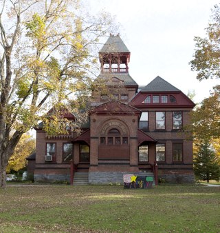
Route 169 is a 47.36-mile-long (76.22 km) state highway in the U.S. states of Connecticut and Massachusetts. It begins in the city of Norwich, Connecticut, and runs 38 miles (61 km) through Northeastern Connecticut, continuing across the state line into Southbridge, Massachusetts. The route ends in Charlton after another nine miles (14 km). A portion of the route in the town center of Pomfret is on the National Register of Historic Places as Pomfret Street Historic District, and 32.10 miles (51.66 km) of the road is designated as the Connecticut State Route 169 National Scenic Byway.

Falls Village is a village and census-designated place in the town of Canaan in Litchfield County, Connecticut, United States. As of the 2010 census it had a population of 538, out of 1,234 in the entire town of Canaan. Because Falls Village is the town center and principal constituent village in Canaan, the entire town is often referred to as "Falls Village". That usage also avoids confusion of the town with Canaan Village in the town of North Canaan, Connecticut, just to the north. Falls Village derives its name from a waterfall, known as Great Falls, on the Housatonic River within the village.

Massachusetts Route 7A is a state highway and alternate to U.S. Route 7 in Berkshire County, Massachusetts. It has two posted segments, with a total length of 5.83 miles (9.38 km). Between these segments, Route 7A is coextensive with US 7.

Route 37 is a north–south state highway in Connecticut running 18.66 miles (30.03 km) from Interstate 84 (I-84) in Danbury north to U.S. Route 7 in New Milford. The northernmost section between the town centers of Sherman and New Milford was once part of an early toll road known as the New Milford and Sherman Turnpike chartered in 1818.

Route 42 is an east–west state highway in Connecticut running for 13.66 miles (21.98 km) from Route 67 in Oxford to Route 10 in Cheshire.

Route 43 is a Connecticut state highway. It is 5.06 miles (8.14 km) long and runs north–south within the town of Cornwall. It connects the town center with the village of Cornwall Hollow near the Canaan town line.

Route 61 is a secondary state highway in rural northwestern Connecticut connecting the towns of Woodbury and Morris. It serves as the main north–south highway within the towns of Bethlehem and Morris.

Massachusetts Route 102 is a 12.33-mile-long (19.84 km) west–east state highway in western Massachusetts. Its western terminus is at the New York border where it connects to New York State Route 22 (NY 22) in Canaan, New York, and its eastern terminus is at the intersection U.S. Route 20 (US 20) and the Massachusetts Turnpike exit 10 in Lee. Along the way it intersects several major highways, including Route 41 in West Stockbridge and US 7 and Route 183 in Stockbridge.

Route 112 is a state highway in northwestern Connecticut, running entirely within the town of Salisbury. The route serves the village of Lime Rock.

Route 136 is a state highway in southwestern Connecticut, running from Darien to Easton. The route was initially established in 1932 to serve the beach communities between Darien and Southport. Its eastern end was relocated in 1963 to head northeast from Westport to Easton instead.

Route 195 is a state highway in northeastern Connecticut, running from the Willimantic section of Windham to the town center of Tolland via Storrs and Mansfield Center. The road is the main thoroughfare to access the main campus of the University of Connecticut.

Canaan is a town in Litchfield County, Connecticut, United States. The population was 1,080 at the 2020 census, down from 1,234 at the 2010 census. The town is part of the Northwest Hills Planning Region. The town of Canaan is often referred to locally by the name of its principal settlement, Falls Village.

U.S. Route 44 (US 44) is an east–west United States Numbered Highway that runs for 237 miles (381 km) through four states in the Northeastern United States. The western terminus is at US 209 and New York State Route 55 (NY 55) in Kerhonkson, New York, a hamlet in the Hudson Valley region. The eastern terminus is at Route 3A in Plymouth, Massachusetts.


