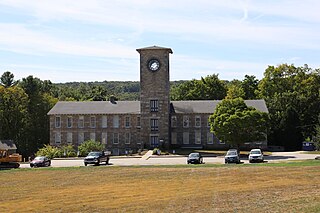
Mansfield is a town in Tolland County, Connecticut, United States. The town is part of the Capitol Planning Region. The population was 25,892 at the 2020 census.
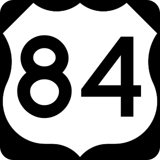
U.S. Route 84 (US 84) is an east–west United States Numbered Highway that started as a short Georgia–Alabama route in the original 1926 scheme. Later, in 1941, it had been extended all the way to Colorado. The highway's eastern terminus is a short distance east of Midway, Georgia, at an Interchange with I-95. The road continues toward the nearby Atlantic Ocean as a county road. Its western terminus is in Pagosa Springs, Colorado, at an intersection with US 160.

Route 15 is a state highway in the U.S. state of Connecticut that runs 83.53 miles (134.43 km) from a connection with New York's Hutchinson River Parkway in Greenwich, Connecticut, to its northern terminus intersecting with Interstate 84 (I-84) in East Hartford, Connecticut. Route 15 consists of four distinct sections: the Merritt Parkway, the Wilbur Cross Parkway, most of the Berlin Turnpike, and part of the Wilbur Cross Highway. The unified designation was applied to these separate highways in 1948 to provide a continuous through route from New York to Massachusetts. The parkway section of Route 15 is often referred to locally as "The Merritt".

Route 32 is a 54.88-mile (88.32 km) primary north–south state highway in the U.S. state of Connecticut, beginning in New London and continuing via Willimantic to the Massachusetts state line, where it continues as Massachusetts Route 32.

U.S. Route 6 (US 6) within the state of Connecticut runs for 116.33 miles (187.21 km) from the New York state line near Danbury to the Rhode Island state line in Killingly. West of Hartford, the route either closely parallels or runs along Interstate 84 (I-84), which has largely supplanted US 6 as a through route in western Connecticut. East of Hartford, US 6 serves as a primary route for travel between Hartford and Providence.

The Wilbur Cross Highway is a freeway running along a portion of Connecticut Route 15 and U.S. Route 5 from Wethersfield to East Hartford, Connecticut, and then continuing northeast as a section of Interstate 84, part of which is also cosigned as U.S. Route 6. The freeway ends at a junction with the tolled Massachusetts Turnpike in Sturbridge, Massachusetts. The entire route was formerly signed as Route 15.

Route 31 is a north–south state highway in Connecticut running for 14.34 miles (23.08 km) from Route 74 in Vernon to Route 32 in Mansfield. Although it is officially logged as an east-west route, it is signed north-south.

Route 74 is a state highway in Connecticut in the eastern part of the Greater Hartford area. It runs from Route 194 in South Windsor to US 44 in Ashford, going through the towns of Ellington, Vernon, Tolland, and Willington. East of its junction with I-84, it becomes a rural collector road.

Route 89 is a state highway in northeastern Connecticut, United States, running from eastern Mansfield to southern Union. It connects the villages of Mansfield Center, Warrenville, and Westford. It is a two-lane rural collector road throughout its entire length, following the path of the Mount Hope River.

Route 71 is a north–south state highway in Connecticut, running from Wallingford to West Hartford. It is the main north–south road of Meriden, Berlin and New Britain.
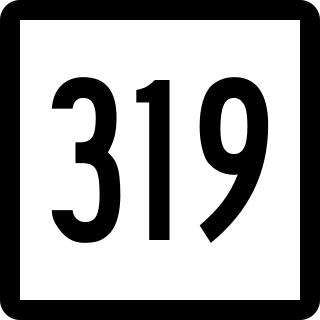
Route 319 is a state highway in northern Connecticut running entirely in Stafford.

Route 316 is a state highway in east central Connecticut running from Hebron to Andover.

Route 203 is a state highway in eastern Connecticut, running entirely within the town of Windham.
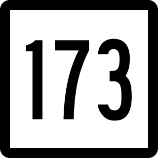
Route 173 is a Connecticut state highway in the southern and western suburbs of Hartford, running from Newington to West Hartford.

Route 177 is a state highway in central Connecticut, running from Plainville to Canton.

Route 195 is a state highway in northeastern Connecticut, running from the Willimantic section of Windham to the town center of Tolland via Storrs and Mansfield Center. The road is the main thoroughfare to access the main campus of the University of Connecticut.

Route 275 is a state highway in northeastern Connecticut running from Coventry to the village of Storrs within the town of Mansfield, and serving as a western feeder to the main campus of the University of Connecticut.
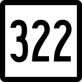
Route 322 is a state highway in west central Connecticut, running from Wolcott to Southington.

Route 372 is a 14.95-mile (24.06 km) state highway in Hartford and Middlesex counties in central Connecticut, United States, running from Plainville to Cromwell, and serving to communicate between the numerous freeways in the area. The section of Route 372 from Route 10 in Plainville to the Plainville-New Britain town line is designated the Joseph E. Tinty Memorial Highway. The section of Route 372 from the interchange with Route 72 in New Britain to the intersection with Route 71A and SR 571 in Berlin is designated the Polish Legion of American Veterans Memorial Highway.

Interstate 84 (I-84) is an east–west Interstate Highway across the state of Connecticut through Danbury, Waterbury, Hartford, and Union.

