
A flood is an overflow of water that submerges land that is usually dry. In the sense of "flowing water", the word may also be applied to the inflow of the tide. Floods are an area of study of the discipline hydrology and are of significant concern in agriculture, civil engineering and public health. Human changes to the environment often increase the intensity and frequency of flooding, for example land use changes such as deforestation and removal of wetlands, changes in waterway course or flood controls such as with levees, and larger environmental issues such as climate change and sea level rise. In particular climate change's increased rainfall and extreme weather events increases the severity of other causes for flooding, resulting in more intense floods and increased flood risk.

The Raritan River is a major river of New Jersey. Its watershed drains much of the mountainous area of the central part of the state, emptying into the Raritan Bay on the Atlantic Ocean.

A storm surge, storm flood, tidal surge, or storm tide is a coastal flood or tsunami-like phenomenon of rising water commonly associated with low-pressure weather systems, such as cyclones. It is measured as the rise in water level above the normal tidal level, and does not include waves.

The New York–New Jersey Harbor Estuary, also known as the Hudson-Raritan Estuary, is in the northeastern states of New Jersey and New York on the East Coast of the United States. The system of waterways of the Port of New York and New Jersey forms one of the most intricate natural harbors in the world and one of the busiest ports of the United States. The harbor opens onto the New York Bight in the Atlantic Ocean to the southeast and Long Island Sound to the northeast.

The Rahway River is a river in Essex, Middlesex, and Union Counties, New Jersey, United States, The Rahway, along with the Elizabeth River, Piles Creek, Passaic River, Morses Creek, the Fresh Kills River, has its river mouth at the Arthur Kill.

Lake Borgne is a lagoon of the Gulf of Mexico in southeastern Louisiana. Although early maps show it as a lake surrounded by land, coastal erosion has made it an arm of the Gulf of Mexico. Its name comes from the French word borgne, which means "one-eyed."
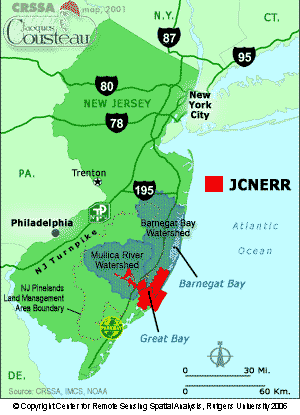
The Jacques Cousteau National Estuarine Research Reserve, located in southeastern New Jersey, encompasses over 110,000 acres (450 km2) of terrestrial, wetland and aquatic habitats within the Mullica River-Great Bay Ecosystem.

Ennore, also spelt Eṇṇūr, is a neighbourhood in Chennai, India. Ennore is situated on a peninsula and is bounded by the Korttalaiyar River, Ennore Creek and the Bay of Bengal. The creek separates south Ennore from the north Ennore which covers major portions of North Chennai Thermal Power Station and Ennore Port. The neighbourhood is served by Ennore railway station. Over the years Ennore has become the hub of a range of industrial projects, mainly thermal power stations, fertilizer factories, industrial ports and coal yards.
Chelsea Wetlands is a riparian marsh on lower Pinole Creek and a tidal wetland at its mouth on San Pablo Bay, in Contra Costa County, northern California. It is located within the city of Hercules, in the East Bay region of the San Francisco Bay Area.
The William T. Davis Wildlife Refuge (WTDWR) is an 814-acre (3.29 km2) wildlife refuge straddling the New Springville and Travis sections of Staten Island. The park was named in honor of Staten Island native William T. Davis, a renowned naturalist and entomologist who along with the Audubon Society started the refuge with an original acquisition of 52 acres (210,000 m2). Additional acreage was acquired in increments and the park is today 814 acres (3.29 km2). Beginning in 2010, the adjacent 223-acre (0.90 km2) North Park section of Freshkills Park has undergone preparation to serve as an expansion of the wildlife refuge.
The December 1981 windstorm was a severe storm that particularly affected southern England, Wales and south west France during 13 December 1981. The storm formed as a secondary low.

The December 1992 nor'easter produced record high tides and snowfall across the northeastern United States. It developed as a low pressure area on December 10 over Virginia, and for two days it remained over the Mid-Atlantic states before moving offshore. In Maryland, the snowfall unofficially reached 48 in (1,200 mm); if verified, the total would have been the highest in the state's history. About 120,000 people were left without power in the state due to high winds. Along the Maryland coast, the storm was less severe than the Perfect Storm in the previous year, although the strongest portion of the storm remained over New Jersey for several days. In the state, winds reached 80 mph (130 km/h) in Cape May, and tides peaked at 10.4 ft (3.2 m) in Perth Amboy. The combination of high tides and 25 ft (7.6 m) waves caused the most significant flooding in the state since the Ash Wednesday Storm of 1962. Several highways and portions of the New York City Subway and Port Authority Trans-Hudson systems were closed due to the storm. Throughout New Jersey, the nor'easter damaged about 3,200 homes and caused an estimated $750 million in damage (1992 USD).

The January 1992 nor'easter was the second in a series of nor'easters in a 14-month period that produced strong winds, high tides, and flooding along the East Coast of the United States. It was a small, short-lived storm that was poorly forecast, intensifying rapidly on January 4 before striking the Eastern Shore of Virginia. The strongest quadrant of the storm moved over Delaware, and winds in the state reached 58 mph (93 km/h). The nor'easter weakened as it moved westward, and it dissipated over Virginia before the energy reformed and redeveloped offshore.

The North Sea flood of 1978 was a storm surge which occurred over 11–12 January causing extensive coastal flooding and considerable damage on the east coast of England between the Humber and Kent. Higher water levels were reached than during the devastating North Sea flood of 1953 from North Shields to King's Lynn, but values were lower towards the Thames. Locally severe flooding occurred in Lincolnshire, The Wash, north Norfolk and Kent. Improvements in flood protection following the devastating flood of 1953 meant that the catastrophic losses seen during that storm were not repeated. The storm caused severe damage to many piers along the east coast of England.
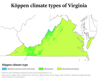
Climate change in Virginia encompasses the effects of climate change, attributed to man-made increases in atmospheric carbon dioxide, in the U.S. state of Virginia.

Climate change in New Jersey is of concern due to its effects on the ecosystem, economy, infrastructure, and people of the U.S. state of New Jersey. According to climatology research by the U.S. National Oceanic and Atmospheric Administration, New Jersey has been the fastest-warming state by average air temperature over a 100-year period beginning in the early 20th century, related to global warming.

Heards Brook is a stream in Woodbridge Township, Middlesex County, New Jersey, United States.
The Woodbrige River is a river in Woodbridge Township, Middlesex County, New Jersey, United States. The river is an important waterway, which frequently floods due to extreme weather caused by climate change, and is expected to increase doing so because of sea level rise. The river includes several conservation areas to protect the diversity of wildlife in the waterway, and the local government is increasingly buying out properties as part of a managed retreat to buffer other properties in the township.
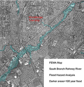
The South Branch Rahway River flows north north through Woodbridge Township, New Jersey before entering the Rahway River in Rahway, New Jersey, 4.5 miles from the Arthur Kill. Its source is the Roosevelt Park lake in Edison, New Jersey.
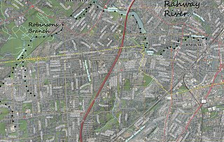
Robinsons Branch is a tributary of the Rahway River in Union and Middlesex Counties, New Jersey, United States.

