
Union County is a county in the northern part of the U.S. state of New Jersey. As of the 2020 United States census, the county was the state's seventh-most-populous county with a population of 575,345, its highest decennial count ever and an increase of 38,846 (+7.2%) from the 2010 census count of 536,499. Its county seat is Elizabeth, which is also the most populous municipality in the county, with a 2020 census population of 137,298, and the largest by area, covering 13.46 square miles (34.9 km2). The county serves as a transition point between the Central Jersey and North Jersey regions of the state.

Rahway is a city in southern Union County, in the U.S. state of New Jersey. A bedroom community of New York City, it is centrally located in the Rahway Valley region, in the New York metropolitan area. The city is 15 miles (24 km) southwest of Manhattan and 5 miles (8.0 km) west of Staten Island.
The Rahway River is a river in Essex, Middlesex, and Union Counties, New Jersey, United States, The Rahway, along with the Elizabeth River, Piles Creek, Passaic River, Morses Creek, the Fresh Kills River, has its river mouth at the Arthur Kill.

The Toms River is a 41.7-mile-long (67.1 km) freshwater river and estuary in Ocean County, New Jersey in the United States.

The Feather River is the principal tributary of the Sacramento River, in the Sacramento Valley of Northern California. The river's main stem is about 73 miles (117 km) long. Its length to its most distant headwater tributary is just over 210 miles (340 km). The main stem Feather River begins in Lake Oroville, where its four long tributary forks join—the South Fork, Middle Fork, North Fork, and West Branch Feather Rivers. These and other tributaries drain part of the northern Sierra Nevada, and the extreme southern Cascades, as well as a small portion of the Sacramento Valley. The total drainage basin is about 6,200 square miles (16,000 km2), with approximately 3,604 square miles (9,330 km2) above Lake Oroville.

Stony Brook, also known as Stoney Brook, is a tributary of the Millstone River in Hunterdon and Mercer counties, New Jersey, in the United States.

The Millstone River is a 38.6-mile-long (62.1 km) tributary of the Raritan River in central New Jersey in the United States.

Alum Creek is 58-mile (93 km) long creek that runs north to south in central Ohio. The creek originates in Morrow County and then flows through Delaware County and finally into Franklin County, where it ends at Big Walnut Creek, which drains into the Scioto River. Alum Creek is a source of drinking water for the city of Westerville, Ohio.

Middle Brook is a tributary of the Raritan River in Somerset County, New Jersey. The stream can be referred to as Rha-weigh-weiros, a Native American name meaning "running from a deep hole", on early maps of the area.

The East Branch Penobscot River is a 75.3-mile-long (121.2 km) tributary of Maine's Penobscot River. It flows in Piscataquis County and Penobscot County.
The East Branch Union River is a 21.6-mile-long (34.8 km) river in Hancock County, Maine. From the outflow of Rocky Pond in Maine Township 22 M D, the river runs 5.3 miles (8.5 km) southwest to Spectacle Pond in Osborn. From the pond's outlet, the river runs 13.0 miles (20.9 km) northwest, southwest, west and southwest to Graham Lake, where it joins the West Branch to form the Union River. The lower section of the East Branch forms the border between Mariaville and Waltham.
The West Branch Union River is a river in Hancock County, Maine. From the outflow of Great Pond in the town of Great Pond, the river runs 20.1 miles (32.3 km) southwest and south to Graham Lake, where it joins the East Branch in Mariaville to form the Union River.

Cranbury Brook, also known as Cranberry Brook, is a tributary of the Millstone River in Middlesex and Monmouth Counties, New Jersey in the United States.

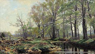
The Rahway River Parkway is a greenway of parkland along the banks the main stem Rahway River and its tributaries in Union County, New Jersey, United States. Created in the 1920s, it was one of the inaugural projects of the newly-created Union County Parks Commission. It was designed by the Olmsted Brothers firm, sons of landscape architect Frederick Law Olmsted. The Rahway River Greenway plan expands on the original design. Many of the crossings of the river are late 19th century or early 20th century bridges. The East Coast Greenway uses paths and roads along the parkway.
Lenape Park is a 450-acre wildlife reserve and park that is part of the Rahway River Parkway in Union County, New Jersey. The park is located in four towns: Westfield, Springfield, Kenilworth, and Cranford.

Pumpkin Patch Brook is a stream in Union and Middlesex counties in the U.S. state of New Jersey. It is a tributary of Robinson's Branch of the Rahway River.
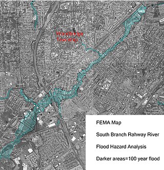
The South Branch Rahway River flows north north through Woodbridge Township, New Jersey before entering the Rahway River in Rahway, New Jersey, 4.5 miles from the Arthur Kill. Its source is the Roosevelt Park lake in Edison, New Jersey.

Marshes Creek is a tidal tributary of the Rahway River in Linden, New Jersey, United States.
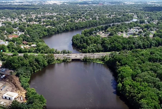
The Robinson's Branch Reservoir is a decommissioned water reservoir in Clark, New Jersey. It is the largest body of water in Union County.

