
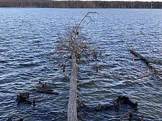
Monmouth County is a county located in the central portion of the U.S. state of New Jersey. It is bordered to its west by Mercer and Middlesex Counties, to its south by Ocean County, to its east by the Atlantic Ocean, and to its north by the Raritan Bay. Monmouth County's geographic area comprises 30% water. The county is part of the Jersey Shore region of the state. It has also been categorized under the Central Jersey region, though it was not among the four counties explicitly listed as included in Central Jersey as part of legislation signed into law in 2023.

Allenhurst is a borough located on the Jersey Shore, in Monmouth County, in the U.S. state of New Jersey. The settlement was named after resident Abner Allen and was incorporated as a borough by an act of the New Jersey Legislature on April 26, 1897, from portions of Ocean Township. As of the 2020 United States census, the borough's population was 472, a decrease of 24 (−4.8%) from the 2010 census count of 496, which in turn reflected a decline of 222 (−30.9%) from the 718 counted in the 2000 census.
Howell Township is a township in Monmouth County, in the U.S. state of New Jersey. The township is the largest municipality in the county by total area, comprising about 61.21 square miles (158.5 km2). It is located in the New York metropolitan area and has been a steadily growing bedroom community of New York City. As of the 2020 United States census, the township's population was 53,537, its highest decennial count ever and an increase of 2,462 (+4.8%) from the 2010 census count of 51,075, which in turn reflected an increase of 2,172 (+4.4%) from the 48,903 counted in the 2000 census.

Interlaken is a borough situated in the Jersey Shore region, within Monmouth County, in the U.S. state of New Jersey. As of the 2020 United States census, the borough's population was 828, an increase of 8 (+1.0%) from the 2010 census count of 820, which in turn had reflected a decline of 80 (−8.9%) from the 900 counted in the 2000 census.

Keansburg is a borough in Monmouth County, in the U.S. state of New Jersey. As of the 2020 United States census, the borough's population was 9,755, a decrease of 350 (−3.5%) from the 2010 census count of 10,105, which in turn reflected a decline of 627 (−5.8%) from 10,732 in the 2000 census.

Little Silver is a borough in Monmouth County, in the U.S. state of New Jersey. As of the 2020 United States census, the borough's population was 6,131, an increase of 181 (+3.0%) from the 2010 census count of 5,950, which in turn reflected a drop of 220 (−3.6%) from the 6,170 counted in the 2000 census.

Loch Arbour is a village situated on the Jersey Shore in Monmouth County, in the U.S. state of New Jersey. As of the 2020 United States census, the village's population was 224, an increase of 30 (+15.5%) from the 2010 census count of 194, which had in turn reflected a decline of 86 (−30.7%) from the 280 recorded at the 2000 census.

Middletown Township is a township in northern Monmouth County, in the U.S. state of New Jersey. As of the 2020 United States census, the township was the state's 20th-most-populous municipality and the largest in the county, with a population of 67,106, an increase of 584 (+0.9%) from the 2010 census count of 66,522, which in turn reflected an increase of 195 residents (0.3%) from its population of 66,327 at the 2000 census, when it was the state's 17th-most-populous municipality.
Millstone Township is a township in western Monmouth County, in the U.S. state of New Jersey. The township is located within the Raritan Valley region and is a part of the New York metropolitan area. As of the 2020 United States census, the township's population was 10,376, a decrease of 190 (−1.8%) from the 2010 census count of 10,566, which in turn reflected an increase of 1,596 (+17.8%) from the 8,970 counted in the 2000 census.

Monmouth Beach is a borough in Monmouth County, in the U.S. state of New Jersey, situated on the Jersey Shore. As of the 2020 United States census, the borough's population was 3,174, a decrease of 105 (−3.2%) from the 2010 census count of 3,279, which in turn had reflected a decline of 316 (−8.8%) from the 3,595 counted at the 2000 census.

Oceanport is a borough situated in the Jersey Shore region, within Monmouth County, in the U.S. state of New Jersey, specifically Central Jersey. As of the 2020 United States census, the borough's population was 6,150, an increase of 318 (+5.5%) from the 2010 census count of 5,832, which in turn reflected an increase of 25 (+0.4%) from the 5,807 counted in the 2000 census.

Upper Freehold Township is a township in Monmouth County, in the U.S. state of New Jersey. As of the 2020 United States census, the township's population was 7,273, an increase of 371 (+5.4%) from the 2010 census count of 6,902, which in turn reflected an increase of 2,620 (+61.2%) from the 4,282 counted in the 2000 census.

West Long Branch is a borough situated within the Jersey Shore region, within Monmouth County, in the U.S. state of New Jersey. As of the 2020 United States census, the borough's population was 8,587, its highest decennial count ever and an increase of 490 (+6.1%) from the 2010 census count of 8,097, which in turn reflected a decline of 161 (−1.9%) from the 8,258 counted in the 2000 census. West Long Branch is the home of Monmouth University.

Eatontown is a borough in Monmouth County, in the U.S. state of New Jersey. As of the 2020 United States census, the borough's population was 13,597, an increase of 888 (+7.0%) from the 2010 census count of 12,709, which in turn reflected a decline of 1,299 (−9.3%) from the 14,008 counted in the 2000 census.

Sea Bright is a borough situated on the Jersey Shore, within Monmouth County, in the U.S. state of New Jersey. As of the 2020 United States census, the borough's population was 1,449, an increase of 37 (+2.6%) from the 2010 census count of 1,412, which in turn had reflected a decline of 406 (−22.3%) from the 1,818 counted in the 2000 census.

Fort Monmouth is a former installation of the Department of the Army in Monmouth County, New Jersey and the site of a major upcoming Netflix film production campus. The site is surrounded by the communities of Eatontown, Tinton Falls and Oceanport, New Jersey, and is located about five miles (8.0 km) from the Atlantic Ocean. It is approximately an hour and 15 minutes south of Manhattan by vehicle.

Monmouth Park is a seasonal NJ Transit commuter rail station on the North Jersey Coast Line, located in Oceanport, New Jersey, and serving the current Monmouth Park Racetrack. The first two locations of Monmouth Park were inside now-closed Fort Monmouth. Both those locations had dedicated rail sidings owned by The Monmouth Park Railroad.
The Oceanport School District is a community public school district that serves students in pre-kindergarten through eighth grade from Oceanport, in Monmouth County, in the U.S. state of New Jersey. The district also includes students from Sea Bright, a non-operating district that was subject to a mandatory merger with Oceanport in 2009.

Adelphia is an unincorporated community located in northern Howell Township, Monmouth County, in the U.S. state of New Jersey. The area is served as United States Postal Service ZIP code 07710. The community borders Freehold Township, and residents who reside in Adelphia use a Freehold mailing address.
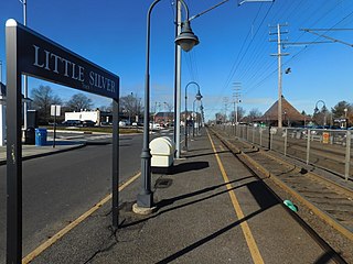
Little Silver is a railway station in Little Silver, Monmouth County, New Jersey, United States. It is served by trains on NJ Transit's North Jersey Coast Line. The station is located in between two grade crossings, and trains can back up traffic when they stop at the station.


