
U.S. Route 9 (US 9) is a north–south United States Numbered Highway in the states of Delaware, New Jersey, and New York in the Northeastern United States. It is one of only two U.S. Highways with a ferry connection ; the other is US 10. US 9 is signed east–west in Delaware and north–south on the rest of its route. The southern terminus of the route is in Laurel, Delaware, at an intersection with US 13, while the highway's northern terminus is at a junction with Interstate 87 (I-87) in Champlain, New York, where the old roadway continues north as the unsigned New York State Route 971B (NY 971B), which ends in a cul-de-sac just short of the Canadian border.

Monmouth County is a county located in the central portion of the U.S. state of New Jersey. It is bordered to its west by Mercer and Middlesex Counties, to its south by Ocean County, to its east by the Atlantic Ocean, and to its north by the Raritan Bay. Monmouth County's geographic area comprises 30% water. The county is part of the Jersey Shore region of the state. It has also been categorized under the Central Jersey region, though it was not among the four counties explicitly listed as included in Central Jersey as part of legislation signed into law in 2023.

Hudson County is the smallest and most densely populated county in the U.S. state of New Jersey. It lies west of the lower Hudson River, which was named for Henry Hudson, the sea captain who explored the area in 1609. Part of New Jersey's Gateway Region in the New York metropolitan area, the county seat is Jersey City, which is the county's largest city in terms of both population and area. The county is part of the North Jersey region of the state.

Williamstown is an unincorporated community and census-designated place (CDP) located in Monroe Township in Gloucester County, in the U.S. state of New Jersey. As of the 2010 U.S. census, Williamstown's population was 15,567.
Howell Township is a township in Monmouth County, in the U.S. state of New Jersey. The township is the largest municipality in the county by total area, comprising about 61.21 square miles (158.5 km2). It is located in the New York metropolitan area and has been a steadily growing bedroom community of New York City. As of the 2020 United States census, the township's population was 53,537, its highest decennial count ever and an increase of 2,462 (+4.8%) from the 2010 census count of 51,075, which in turn reflected an increase of 2,172 (+4.4%) from the 48,903 counted in the 2000 census.
Wall Township is a township within Monmouth County, in the U.S. state of New Jersey. Crisscrossed by several different highways within the heart of the Jersey Shore region, the township is a transportation hub of Central New Jersey and a bedroom suburb of New York City, in the New York Metropolitan Area. As of the 2020 United States census, Wall Township's population was 26,525, its highest decennial count ever and an increase of 361 (+1.4%) from the 2010 census count of 26,164, which in turn reflected an increase of 903 (+3.6%) from the 25,261 counted in the 2000 census.

Howell High School (HHS) is a four-year comprehensive public high school serving students in ninth through twelfth grades located in Howell Township in Monmouth County, in the U.S. state of New Jersey, operating as one of six secondary schools of the Freehold Regional High School District. The school serves all students from Farmingdale and those from some portions of Howell Township. The school has been accredited by the Middle States Association of Colleges and Schools Commission on Elementary and Secondary Schools since 1970. Although located in Howell, the school has a Farmingdale mailing address.

Kenvil is an unincorporated community and census-designated place (CDP) located within Roxbury Township, in Morris County, in the U.S. state of New Jersey, that had been part of the Succasunna-Kenvil CDP as part of the 2000 United States Census, at which time the population of the combined was 12,569. For the 2010 census, the area was split into two CDPs, Succasunna and Kenvil.

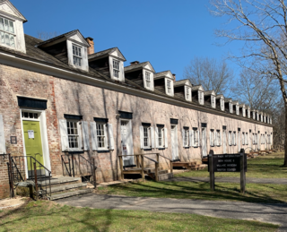
Allaire State Park is a park located in Howell and in Wall Township in Monmouth County, New Jersey, United States, near the borough of Farmingdale, operated and maintained by the New Jersey Division of Parks and Forestry and is part of the New Jersey Coastal Heritage Trail Route. The park is known for its restored 19th century ironworks, Allaire Village, on the park premises. It is named after James P. Allaire, founder of the Howell Works at the same site. The park also hosts the Pine Creek Railroad, a tourist railroad.

Adelphia is an unincorporated community located in northern Howell Township, Monmouth County, in the U.S. state of New Jersey. The area is served as United States Postal Service ZIP code 07710. The community borders Freehold Township, and residents who reside in Adelphia use a Freehold mailing address.

County Route 524 is a county highway in the U.S. state of New Jersey. The highway extends 39.90 miles (64.21 km) from the White Horse Circle in Hamilton Township to Route 71 in Spring Lake Heights.
Charles H. Boud was an American Democratic Party politician from New Jersey, who served on the Monmouth County, New Jersey Board of Chosen Freeholders and the New Jersey General Assembly.

New Durham is a neighborhood in North Bergen Township in Hudson County, in the U.S. state of New Jersey. It is located near the foot of Union Turnpike and Bergen Turnpike, and south of the Tonnelle Avenue Station of the Hudson Bergen Light Rail. It is one of the few residential areas along the otherwise industrial/commercial Tonnelle Ave, and site of one of the town's main post offices.
Squankum is an unincorporated community located within Howell Township in Monmouth County, in the U.S. state of New Jersey. The name Squankum was used for a town in Gloucester County, which was changed to present day Williamstown, due to postal regulations that prohibited the two towns from having the same name.

Jerseyville is an unincorporated community located within Howell Township in Monmouth County, in the U.S. state of New Jersey. It is primarily a rural area within the northern part of the township, near Colts Neck and Freehold. Route 33 Business travels through Jerseyville, with some development, including a gas station, a convenience store, a church, and several residences.

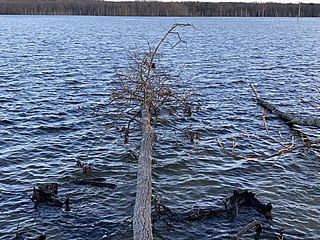
Freewood Acres is an unincorporated community located within Howell Township in Monmouth County, in the U.S. state of New Jersey. The area is made up of mostly single-story homes arranged along a street grid in the northern reaches of the Pine Barrens. U.S. Route 9 runs through the center of the community just north of its interchange with Interstate 195. The Land O'Pines Elementary School and Manasquan Reservoir County Park exist to the east of the community. It became the center of the Kalmyk American community in the latter part of the 20th century.

Lower Squankum is an unincorporated community located within Howell Township in Monmouth County, in the U.S. state of New Jersey. The settlement is located along Lakewood-Farmingdale Road at its intersection with Herbertsville Road and Old Tavern Road in the eastern side of the township. It is also located near the boundary of Allaire State Park and is south of Interstate 195's exit 31. Nearby the community are the remains of the Lower Squankum Mill and the Lower Squankum Friends Burial Site, located within the median of CR 547 at the aforementioned interchange.
Bog Creek Farm, located in Howell Township, New Jersey, is a designated Environmental Protection Agency (EPA) Superfund site. Lying on 12 acres of land, Bog Creek Farm is home to several hazardous and life-threatening contamination beginning in 1973 and continuing for a year. Over a decade later, actions began to take place to clean and restore the contaminated soil and water. Bog Creek Farm is situated near several other farms that house horses, growing crops and flowers, and livestock. Less than a mile down the road lies Allaire State Park, a park used by golfers, hunters, and fisherman.
The Zschiegner Refining Company (ZRC) was located in Howell, New Jersey, and operated as a metal refining facility. Some of their operations included stripping the chemicals off of precious metals from watch bands, photographic film, and electrical components. In 1992, the United States Environmental Protection Agency (EPA) discovered that 3,000 chemicals had contaminated the soil, surface water, and groundwater. These areas were contaminated due to discharge of waste to the ground surface, the movement of waste and contamination downhill from the site building, along with surface water runoff. When the EPA investigated the site and found the chemicals in the groundwater and soil, they shut down the company that same year in 1992. In that area, the environment and people were affected, especially the workers in the facility. After a Hazard Ranking System report was conducted by the EPA, the site was placed on the National Priorities List in March 1998. In 2008, the cleanup was completed, but groundwater and wetland is still being monitored.


