
Shrewsbury Township is a township situated in the Jersey Shore region, within Monmouth County, in the U.S. state of New Jersey. As of the 2020 United States census, the township's population was 1,076, a decrease of 65 (−5.7%) from the 2010 census count of 1,141, which in turn reflected an increase of 43 (+3.9%) from the 1,098 counted in the 2000 census.

Tinton Falls is a borough in Monmouth County, in the U.S. state of New Jersey. Located within the heart of the Jersey Shore region, the borough is a commercial hub of Central Jersey and is an established bedroom suburb of New York City, in the New York Metropolitan Area. As of the 2020 United States census, the borough's population was 19,181, an increase of 1,289 (+7.2%) from the 2010 census count of 17,892, which in turn reflected an increase of 2,839 (+18.9%) from the 15,053 counted in the 2000 census.

Eatontown is a borough in Monmouth County, in the U.S. state of New Jersey. As of the 2020 United States census, the borough's population was 13,597, an increase of 888 (+7.0%) from the 2010 census count of 12,709, which in turn reflected a decline of 1,299 (−9.3%) from the 14,008 counted in the 2000 census.
Monmouth Regional High School is a regional, four-year public high school and public school district based in Tinton Falls, Monmouth County, New Jersey, United States, that serves students in ninth through twelfth grades from Eatontown, Shrewsbury Township and Tinton Falls, along with students from the military installation of Naval Weapons Station Earle. The school has been accredited by the Middle States Association of Colleges and Schools Commission on Elementary and Secondary Schools since 1967. The school is the district's only high school facility.
The Tinton Falls School District is a regional elementary school district in Monmouth County, in the U.S. state of New Jersey, serving students in pre-kindergarten through eighth grades. Students from Tinton Falls are a majority of the district's enrollment, together with students from the neighboring community of Shrewsbury Township and the dependent children of military families based at Naval Weapons Station Earle.

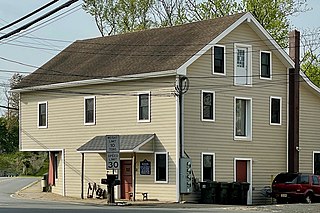
Imlaystown is an unincorporated community located along County Route 43 and Davis Station Road within Upper Freehold Township in Monmouth County in the U.S. state of New Jersey. It is located in ZIP code 08526. The community is accessible from Exit 11 of Interstate 195.
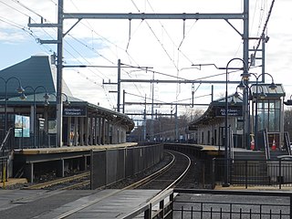
Aberdeen–Matawan is a station on NJ Transit's North Jersey Coast Line, located in Aberdeen and Matawan, Monmouth County, New Jersey, United States. This station, convenient to Route 35 and the PNC Bank Arts Center, is popular with both commuters and concertgoers, and is the busiest station on the line between Bay Head and Rahway.
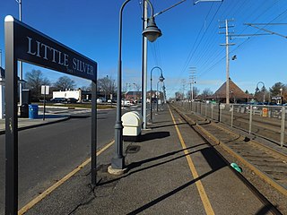
Little Silver is a railway station in Little Silver, Monmouth County, New Jersey, United States. It is served by trains on NJ Transit's North Jersey Coast Line. The station is located in between two grade crossings, and trains can back up traffic when they stop at the station.

Shadow Lawn is a historic building on the campus of Monmouth University in West Long Branch, Monmouth County, New Jersey, United States. Built in 1927 for Hubert T. Parson, president of the F.W. Woolworth Company, it is one of the last large estate houses to be built before the Great Depression. It was designated a National Historic Landmark in 1985 for its architecture.

Audenried Cottage is located in Spring Lake, Monmouth County, New Jersey, United States. The building was built in 1909 and added to the National Register of Historic Places on March 8, 1991.

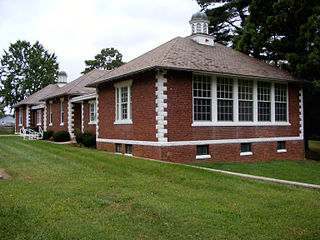
The Clarksburg School is located in the Clarksburg section of Millstone Township, Monmouth County, New Jersey, United States. The building was built in 1925 and added to the National Register of Historic Places on November 12, 1999.
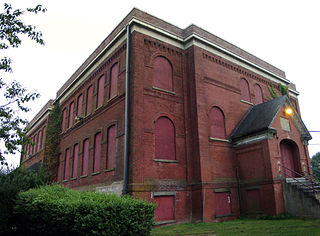
The Court Street School is located in Freehold Borough, Monmouth County, New Jersey, United States. The building was built in 1921 and was added to the National Register of Historic Places on August 4, 1995.
The North Long Branch School-Primary No. 3 is located in Long Branch, Monmouth County, New Jersey, United States. The building was built in 1891 and added to the National Register of Historic Places on July 28, 1999.

The Holmes–Hendrickson House is located at 62 Longstreet Road, adjacent to Holmdel Park, in Holmdel Township of Monmouth County, New Jersey, United States. The historic Dutch-Flemish farmhouse was built around 1754. It was documented as the Hendrick Hendrickson House by the Historic American Buildings Survey (HABS) in 1939. The house was moved from its original location, on the Bell Labs Holmdel Complex, in 1959. It was added to the National Register of Historic Places on April 26, 1978, for its significance in agriculture and architecture. The house is one of several houses owned and operated as a historic house museum by the Monmouth County Historical Association.

The Allen House is located in the borough of Shrewsbury in Monmouth County, New Jersey, United States. The historic house, which would later function as a tavern, was built around 1710 as a second residence for the Stillwell family of New York. Richard, a wealthy merchant, and his wife Mercy had eight children who were brought up primarily in Shrewsbury. By 1754, after Richard and Mercy had died, their heirs sold the property to Josiah Halstead who transformed the home into the Blue Ball Tavern, "the most noted tavern in Shrewsbury." Taverns served as community centers in the 18th century as much as places to drink and eat. The Vestry of Christ Church held meetings there as did the Shrewsbury Library Company and the Monmouth County Circuit Court.

Allentown Mill is a historic grist mill located at 42 South Main Street in Allentown of Monmouth County, New Jersey. The mill was built in 1855, replacing the original mill built here by Nathan Allen in 1706. It was added to the National Register of Historic Places on February 14, 1978 for its significance in agriculture, commerce, and industry.

Arneytown is an unincorporated community located along Province Line Road on the border of North Hanover Township in Burlington County and Upper Freehold Township in Monmouth County of New Jersey. It is two miles (3.2 km) north of Jacobstown. Province Line Road was on the boundary line between the Provinces of East Jersey and West Jersey. The area was once called Upper Freehold by 18th-century Quaker settlers. With the establishment of the first post office in 1827, it became known as Arneytown.

Walnford is an unincorporated community located along Crosswicks Creek within Upper Freehold Township in Monmouth County, in the U.S. state of New Jersey. Walnford was named for Richard Waln, the original owner of the town site.

George Taylor House is in Freehold Borough, Monmouth County, New Jersey, United States on the corner of Broadway and Dutch Lane Road across from Freehold High School. The house was built in circa 1870 by George Taylor, the son of John G. Taylor and Cary Conover Taylor. John G. Taylor was of Scottish ancestry, while Cary Conover was of Dutch ancestry. John G. Taylor was the proprietor of Taylors Mills, a successful family business that George continued to run in his father's footsteps. The grist mill was successful during the mid-late 19th century, as new markets were opening up with the advent of extensive railroad networks.
Salter's Mill is a historic gristmill built c. 1897 and located at 33 Imlaystown Road in the Imlaystown section of Upper Freehold Township in Monmouth County, New Jersey. It was added to the National Register of Historic Places on September 29, 1980, for its significance in agriculture, architecture, and exploration/settlement. The mill is next to a 28-acre (11 ha) mill pond, which was also used in the ice business. In 1985, it was also listed as a contributing property of the Imlaystown Historic District.


