Lower New York Bay is a section of New York Bay south of the Narrows. The eastern end of the Bay is marked by two spits of land, Sandy Hook, New Jersey, and Rockaway, Queens. The waterway between the spits connects the Bay to the Atlantic Ocean at the New York Bight. Traversing the floor of the Bay southeasterly from the Narrows to the Bight and beyond is Hudson Canyon.

The New York–New Jersey Harbor Estuary, also known as the Hudson-Raritan Estuary, is in the northeastern states of New Jersey and New York on the East Coast of the United States. The system of waterways of the Port of New York and New Jersey forms one of the most intricate natural harbors in the world and one of the busiest ports of the United States. The harbor opens onto the New York Bight in the Atlantic Ocean to the southeast and Long Island Sound to the northeast.

The Sandy Hook Lighthouse, located about one and a half statute miles (2.4 km) inland from the tip of Sandy Hook, New Jersey, is the oldest working lighthouse in the United States. It was designed and built on June 11, 1764 by Isaac Conro. At that time, it stood only 500 feet from the tip of Sandy Hook; however, today, due to growth caused by littoral drift, it is almost one and a half miles (2.4 km) inland from the tip. It was listed as a National Historic Landmark in 1964 and added to the National Register of Historic Places on October 15, 1966, for its significance in commerce and transportation.

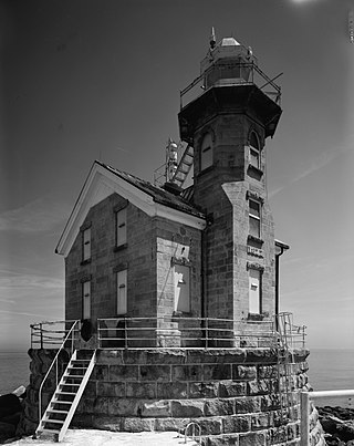
The Navesink Twin Lights is a non-operational lighthouse and museum located in Highlands, Monmouth County, New Jersey, United States, overlooking Sandy Hook Bay, the entrance to New York Harbor, and the Atlantic Ocean. The Twin Lights, as the name implies, are a pair of beacons located 246 feet (75 m) above sea level on the headlands of the Navesink Highlands.
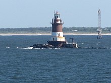
Great Beds Light is a sparkplug lighthouse in Raritan Bay, about 1 mile (1.6 km) from South Amboy of Middlesex County, New Jersey, United States. Over the years the lighthouse has become the symbol for the city of South Amboy. Named as Great Beds Light Station, it was added to the National Register of Historic Places on May 29, 2008, for its significance in architecture, engineering, transportation, and maritime history.

The Port of New York and New Jersey is the port district of the New York-Newark metropolitan area, encompassing the region within approximately a 25-mile (40 km) radius of the Statue of Liberty National Monument.

The Raritan Bayshore is a region in central sections in the state of New Jersey. It is the area around Raritan Bay from The Amboys to Sandy Hook, in Monmouth and Middlesex counties, including the towns of Woodbridge, Perth Amboy, South Amboy, Sayreville, Old Bridge, Matawan, Aberdeen, Keyport, Union Beach, Hazlet, Keansburg, Middletown, Atlantic Highlands, and Highlands. It is the northernmost part of the Jersey Shore, located just south of New York City. At Keansburg is a traditional amusement park while at Sandy Hook are found ocean beaches. The Sadowski Parkway beach area in Perth Amboy, which lies at the mouth of the Raritan River, was deemed the "Riviera of New Jersey" by local government. In recent years many of the beaches on the Bayshore area have been rediscovered and upgraded.

The Baltimore Harbor Light, officially Baltimore Light and historically Baltimore Harbor Lighthouse is a privately owned caisson lighthouse in the Chesapeake Bay in Maryland. First lit in 1908, it sits at the mouth of the Magothy River, marking the channel which leads northwest to the opening of the Patapsco River, which then leads into the Baltimore harbor. The light is located adjacent to the mouth of the Magothy River. At the time of its construction, it was the world's tallest caisson lighthouse. In June 2006, Baltimore Light was sold at auction to private owners by the General Services Administration for $260,000; the U.S. Coast Guard maintains rights to operate a light on the structure.

The Robbins Reef Light Station is a sparkplug lighthouse located off Constable Hook in Bayonne, Hudson County, New Jersey, United States, along the west side of Main Channel, Upper New York Bay. The tower and integral keepers quarters were built in 1883. It replaced an octagonal granite tower built in 1839. The U.S. Coast Guard owned and operated the light station until the 2000s.

Southwest Ledge Light is an active lighthouse marking the main entrance channel to the harbor of New Haven, Connecticut. Completed in 1877, it was one of the first to be built on a cylindrical iron foundation, an innovation by Maj. George H. Elliot to address shifting ice that is regarded to be very important in lighthouse design. The lighthouse was listed on the National Register of Historic Places in 1990 as Southwest Ledge Lighthouse.
Stratford Shoal Light, officially Stratford Shoal Light, is a lighthouse on a shoal in the middle of Long Island Sound approximately halfway between Port Jefferson, New York and Bridgeport, Connecticut.

Sandy Point Shoal Light is a brick three story lighthouse on a caisson foundation that was erected in 1883. It lies about 0.6 mi (0.97 km) off Sandy Point, north of the Chesapeake Bay Bridge, from whose westbound span it is readily visible.

Wolf Trap Light is a caisson lighthouse in the Virginia portion of the Chesapeake Bay, about seven and a half miles northeast of New Point Comfort Light. It is listed on the National Register of Historic Places.

Thimble Shoal Light is a sparkplug lighthouse in the Virginia portion of Chesapeake Bay, north of the Hampton Roads channel. The third light at this location, it is listed on the National Register of Historic Places.

Palmer Island Light Station is a historic lighthouse in New Bedford Harbor in New Bedford, Massachusetts, USA. The lighthouse was built in 1849 out of stone rubble. It was discontinued when the harbor's hurricane barrier was built in the early 1960s, as its location immediately north of the barrier was no longer an outlying danger and there are lights on either side of the barrier opening.

The Brandywine Shoal Light is a lighthouse on the north side of the ship channel in Delaware Bay on the east coast of the United States, west of Cape May, Cape May County, New Jersey, United States. It was the site of the first screw-pile lighthouse in the United States.

The Miah Maull Shoal Light is a lighthouse on the north side of the ship channel in Delaware Bay, off of Cumberland County, New Jersey on the East Coast of the United States, southwest of the mouth of the Maurice River.
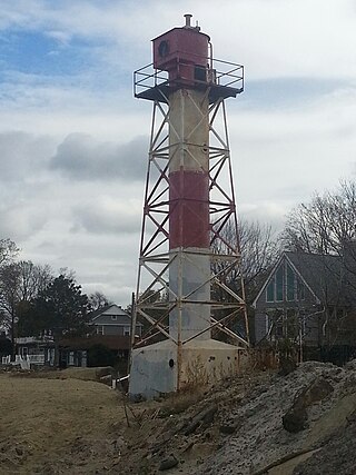
The Conover Beacon is a lighthouse in Leonardo section of Middletown Township, Monmouth County, New Jersey, United States, that functioned as the front light of the now-discontinued Chapel Hill Range.
The Chapel Hill Rear Range Light is a lighthouse located off of Middletown Township in Monmouth County, New Jersey, United States, which functioned as the rear light of the now-discontinued Chapel Hill Range.

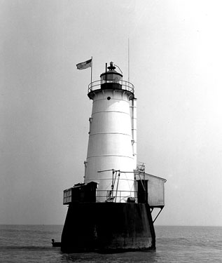
Old Orchard Shoal Light was a sparkplug lighthouse in lower New York Bay marking a large shoal area. It was destroyed by Hurricane Sandy on October 29, 2012.