This article needs additional citations for verification .(September 2017) |
This is a list of all lighthouses in the U.S. state of New Jersey as identified by the United States Coast Guard. [1]
| Name | Image | Location | Coordinates | Year first lit | Automated | Year deactivated | Current Lens | Focal Height | Tower Height |
|---|---|---|---|---|---|---|---|---|---|
| Absecon Light |  | Atlantic City | 1857 | Never | 1933 | Decorative | 167 ft (51 m) | 171 ft (52 m) | |
| Barnegat Lighthouse |  | Barnegat Light [2] | 1835 (Former) 1857 (Current) | 1927 | Active (Inactive: 1944–2009) [3] | VRB-25 | 163 ft (50 m) | 169 ft (52 m) | |
| Brandywine Shoal Light |  | Delaware Bay (Lower) | 1828 (Former) 1914 (Current) | 1974 | Active | Unknown | 60 ft (18 m) | 46 ft (14 m) | |
| Cape May Light | 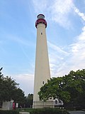 | Cape May Point | 1823 (Former) 1859 (Current) | 1933 | Active (Inactive: 1940–1945) | VRB-25 | 160 ft (50 m) | 157 ft (48 m) (165 ft (50 m) above sea level) | |
| Chapel Hill Rear Range Light | Leonardo | 1856 | Never | 1957 (Now a private house) | None | Unknown | 55 ft (orig.) 45 ft (current) | ||
| Conover Beacon | | Leonardo | 1856 | 1941 | 1957 | None | Unknown | 55 ft (orig.) 45 ft (current) | |
| Cross Ledge Light | Downe Township | 1875 | Never | 1910 (Now ruins) | None | 58 ft (18 m) | Unknown | ||
| East Point (Maurice River) Light | 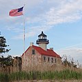 | Heislerville | 1849 | 1911 | Active (Inactive: 1941–1980) | Fourth-order Fresnel | 43 ft (13 m) | 40 ft (12.2 m) | |
| Elbow of Cross Ledge Light |  | Delaware Bay (Middle) | 1910 | 1951 | 1953 (Destroyed) | None | 61 ft (19 m) | Unknown | |
| Finns Point Range Light |  | Pennsville Township | 1877 | 1934 | 1950 | None | Unknown | 115 ft (35 m) | |
| Great Beds Light |  | South Amboy | 1880 | 1945 | Active | Unknown | 62 ft (19 m) | 61 ft (19 m) | |
| Hereford Inlet Light |  | North Wildwood | 1874 | 1986 (Relit) | Active (Inactive: 1964–1986) | VRB-25 | 56 ft (17 m) | 57 ft (17 m) | |
| Ludlam's Beach Light |  | Sea Isle City | 1885 | Never | 1924 (Destroyed) | None | Unknown | 36 ft (11 m) | |
| Miah Maull Shoal Light | 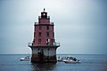 | Downe Township | 1913 | 1973 | Active | 500mm | 59 ft (18 m) | 46 ft (14 m) | |
| Navesink Twin Lights |  | Highlands | 1828 (Former) 1862 (Current) | 1949 | Active (North tower) | Unknown | Unknown | Unknown | |
| Robbins Reef Light |  | Bayonne | 1839 (Former) 1883 (Current) | Unknown | Active | 300mm | 56 ft (17 m) | 45 ft (14 m) | |
| Romer Shoal Light | 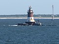 | Lower New York Bay | 1838 (Former) 1898 (Current) | 1966 | Active | 190mm | 54 ft (16 m) | 54 feet (16 m) | |
| Sandy Hook Light | 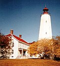 | Middletown Township (Sandy Hook) | 1764 | 1941 | Active | Unknown | 89 ft (27 m) | 103 ft (31 m) | |
| Sea Girt Light |  | Sea Girt | 1896 | Never | 1955 | None | 60 ft (18 m) | 44 ft (13 m) | |
| Ship John Shoal Light |  | Delaware Bay (Upper) | 1877 | 1973 | Active | VRB-25 | 50 ft (15 m) | 46 ft (14 m) | |
| Tinicum Island Rear Range Light |  | Paulsboro | 1880 | 1933 | Active | DCB-24 | 112 ft (34 m) | 85 ft (26 m) | |
| Tucker's Beach Light | 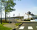 | Tuckerton | N/A | 1848 (Original) 1980s (Replica) | Never | 1927 (Destroyed) | LED (Non-navigational replica) | Unknown | Unknown |
| Waackaack Rear Range Light | Keansburg | 1856 (The last L.H. was built in 1894) | Never | 1959 (Scrapped) | None | Unknown | 96 ft (29 m) (first) 106 ft (32 m) (second) |
