Heislerville, New Jersey

Last updated

Heislerville, New Jersey
United Methodist Church, Heislerville, NJ.jpg
Heislerville United Methodist Church
Location map of Cumberland County, New Jersey.svg
Red pog.svg
Heislerville
Location in Cumberland County
USA New Jersey relief location map.svg
Red pog.svg
Heislerville
Location in New Jersey
Usa edcp relief location map.png
Red pog.svg
Heislerville
Location in the United States
Coordinates: 39°13′23″N74°59′33″W / 39.22306°N 74.99250°W / 39.22306; -74.99250 [1]
Country Flag of the United States.svg  United States
State Flag of New Jersey.svg  New Jersey
County Cumberland
Township Maurice River
Area
[2]
  Total0.72 sq mi (1.86 km2)
  Land0.72 sq mi (1.86 km2)
  Water0.00 sq mi (0.00 km2)
Elevation
[1]
10 ft (3 m)
Population
 (2020) [3]
  Total227
  Density316.16/sq mi (122.03/km2)
Time zone UTC−05:00 (Eastern (EST))
  Summer (DST) UTC−04:00 (Eastern (EDT))
FIPS code 34-30810 [4]
GNIS feature ID877035 [1]

Heislerville is an unincorporated community and census-designated place [5] (CDP) that is part of Maurice River Township in Cumberland County in the U.S. state of New Jersey. [1] [6] [7] It was named after the Heisler family, prominent members of the Methodist Episcopal Church established here in 1828. [8]

Contents

The community borders the Maurice River and Delaware Bay; bayshore areas are East Point and Thompson's Beach, now flooded by the state of New Jersey for use as a bird watch conservatory. The East Point Lighthouse was built in 1849, located on the northern side of Delaware Bay at the mouth of the circuitous Maurice River. The lighthouse is a restful place to fish or hike and is open a few days every year. It is still a working light house but is only operated remotely, having not been staffed for years. It was added to the National Register of Historic Places in 1995 for its significance in engineering, maritime history, and transportation. [9]

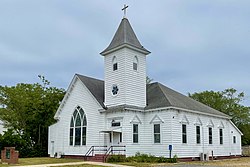
Today, aside from truck gardens, small fishing operations, and a couple of marinas on state-leased land off Matt's Landing Road; the community has no shops or businesses. The major employer is the state of New Jersey, as Maurice River Township is home to three prisons; Bayside, South Woods, and Southern State. In addition to the Heislerville United Methodist Church, located within the community is the Heislerville Volunteer Fire Company.

Demographics

Heislerville's population as of the 2020 United States census was 227, [3] while the 2010 census showed a count of 451.[ citation needed ] There are approximately 200 housing units in its approximate nine-mile radius of which 8.17 square miles (21.2 km2) is land and 0.02 square miles (0.052 km2) is water.

Historical population
CensusPop.Note
2020 227
U.S. Decennial Census [10]

Related Research Articles

<span class="mw-page-title-main">Maurice River Township, New Jersey</span> Township in Cumberland County, New Jersey, United States

Maurice River Township is the easternmost township in Cumberland County, in the U.S. state of New Jersey. The township, and all of Cumberland County, is part of the Vineland-Bridgeton metropolitan statistical area for statistical purposes, and of the Philadelphia-Wilmington-Camden, PA-NJ-DE-MD combined statistical area, also known as the Delaware Valley or Philadelphia metropolitan area. As of the 2020 United States census, the township's population was 6,218, a decrease of 1,758 (−22.0%) from the 2010 census count of 7,976, which in turn reflected an increase of 1,048 (+15.1%) from the 6,928 counted in the 2000 census.

<span class="mw-page-title-main">Kingston, New Jersey</span> Populated place in Middlesex and Somerset counties, New Jersey, US

Kingston is an unincorporated community and census designated place (CDP) along the border of South Brunswick Township in Middlesex County and Franklin Township in Somerset County, and also located relatively near Princeton in Mercer County in the U.S. state of New Jersey. The historic settlement is in the Raritan Valley region, located along the course of the Millstone River. As of the 2010 United States Census, the CDP's population was 1,493, of which 1,222 were in South Brunswick Township and 271 in Franklin Township.

<span class="mw-page-title-main">Port Elizabeth, New Jersey</span> Populated place in Cumberland County, New Jersey, US

Port Elizabeth is an unincorporated community and census-designated place (CDP) located within Maurice River Township in Cumberland County, in the U.S. state of New Jersey. The area is served as United States Postal Service ZIP Code 08348.

<span class="mw-page-title-main">Titusville, New Jersey</span> Populated place in Mercer County, New Jersey, US

Titusville is an unincorporated community and census-designated place (CDP) located within Hopewell Township in Mercer County, in the U.S. state of New Jersey. The area includes a post office with its own ZIP Code (08560), several restaurants, gas stations, a firehouse, and a small cluster of homes. The Washington Crossing State Park, dedicated to George Washington's crossing of the Delaware River in 1776, is adjacent to the community.

<span class="mw-page-title-main">Newport, Cumberland County, New Jersey</span> Populated place in Cumberland County, New Jersey, US

Newport is an unincorporated community and census-designated place (CDP) located within Downe Township in Cumberland County, in the U.S. state of New Jersey. The area is served as United States Postal Service ZIP Code 08345.

<span class="mw-page-title-main">Delmont, New Jersey</span> Populated place in Cumberland County, New Jersey, US

Delmont is an unincorporated community and census-designated place (CDP) located within Maurice River Township, in Cumberland County, in the U.S. state of New Jersey. The area is served as United States Postal Service ZIP Code 08314. It was first listed as a CDP in the 2020 census with a population of 122.

Six Mile Run is an unincorporated community and census-designated place (CDP) located in Franklin Township, in Somerset County, in the U.S. state of New Jersey. As of the 2010 United States Census, the CDP's population was 3,184.

<span class="mw-page-title-main">Griggstown, New Jersey</span> Populated place in Somerset County, New Jersey, US

Griggstown is an unincorporated community and census-designated place (CDP) located within Franklin Township, in Somerset County, in the U.S. state of New Jersey. As of the 2010 United States Census, the CDP's population was 819. The area was first settled around 1733.

<span class="mw-page-title-main">East Millstone, New Jersey</span> Populated place in Somerset County, New Jersey, US

East Millstone is an unincorporated community and census-designated place (CDP) located in Franklin Township in Somerset County, in the U.S. state of New Jersey.

<span class="mw-page-title-main">Delaware, Warren County, New Jersey</span> Census-designated place in Middlesex County, New Jersey, US

Delaware is an unincorporated community and census-designated place (CDP) located along the Delaware River within Knowlton Township in Warren County, New Jersey. It was created as part of the 2010 United States Census. As of the 2010 Census, the CDP's population was 150. The area is served as United States Postal Service ZIP Code 07833.

<span class="mw-page-title-main">Asbury, New Jersey</span> Populated place in Warren County, New Jersey, US

Asbury is an unincorporated community and census-designated place (CDP) located within Franklin Township in Warren County, in the U.S. state of New Jersey, that was created as part of the 2010 United States Census. As of the 2010 Census, the CDP's population was 273.

<span class="mw-page-title-main">Crosswicks, New Jersey</span> Populated place in Burlington County, New Jersey, US

Crosswicks is an unincorporated community and census-designated place (CDP) located within Chesterfield Township in Burlington County, in the U.S. state of New Jersey. The area is served as United States Postal Service ZIP Code 08515.

<span class="mw-page-title-main">Mauricetown, New Jersey</span> Populated place in Cumberland County, New Jersey, US

Mauricetown is a census-designated place and unincorporated community that is part of Commercial Township in Cumberland County, in the U.S. state of New Jersey.

Cumberland is a small unincorporated community located within Maurice River Township in Cumberland County, New Jersey, United States. For statistical purposes, Cumberland and neighboring Hesstown together comprise the Cumberland-Hesstown census-designated place.

<span class="mw-page-title-main">Finesville, New Jersey</span> Populated place in Warren County, New Jersey, US

Finesville is an unincorporated community and census-designated place (CDP) located within Pohatcong Township in Warren County, in the U.S. state of New Jersey. The CDP was defined as part of the 2010 United States Census. As of the 2010 Census, the CDP's population was 175.

<span class="mw-page-title-main">Flatbrookville, New Jersey</span> Unincorporated community in New Jersey, United States

Flatbrookville is an unincorporated community located along Old Mine Road within Walpack Township, in Sussex County, New Jersey, United States. It is named after the Flat Brook, a tributary of the Delaware River, which flows through the community. The area is now part of the Delaware Water Gap National Recreation Area.

<span class="mw-page-title-main">Millbrook, New Jersey</span> Unincorporated community in New Jersey, United States

Millbrook, also known as Millbrook Village, is an unincorporated community located along Old Mine Road within Hardwick Township, formerly Pahaquarry Township, in Warren County, New Jersey, United States. It is named after the Mill Brook, now known as Van Campens Mill Brook, a tributary of the Delaware River. The area is now part of the Delaware Water Gap National Recreation Area.

Othello is an unincorporated community and census-designated place located within Greenwich Township, Cumberland County, in the U.S. state of New Jersey. It was first listed as a CDP in the 2020 census with a population of 132.

Cumberland-Hesstown is a census-designated place (CDP) located in the northern part of Maurice River Township in Cumberland County, in the U.S. state of New Jersey. Consisting of the unincorporated communities of Cumberland and Hesstown, it is in the eastern part of the county. New Jersey Route 49 passes through the CDP, leading northwest 6 miles (10 km) to Millville and southeast 11 miles (18 km) to Tuckahoe.

Greenwich is an unincorporated community and census-designated place (CDP) in Cumberland County, in the U.S. state of New Jersey. It is in the western part of the county, in the southeast part of Greenwich Township, on the northwest side of the tidal Cohansey River, 4 miles (6 km) northeast of its mouth at Delaware Bay. The community is 7 miles (11 km) southwest of Bridgeton, the county seat.

References

  1. 1 2 3 4 "Heislerville". Geographic Names Information System . United States Geological Survey, United States Department of the Interior.
  2. "ArcGIS REST Services Directory". United States Census Bureau. Retrieved October 11, 2022.
  3. 1 2 Census Data Explorer: Heislerville CDP, New Jersey, United States Census Bureau. Accessed June 15, 2023.
  4. Geographic Codes Lookup for New Jersey, Missouri Census Data Center. Accessed June 9, 2023.
  5. State of New Jersey Census Designated Places - BVP20 - Data as of January 1, 2020, United States Census Bureau. Accessed February 15, 2023.
  6. "Locality Search". State of New Jersey.
  7. Gannett, Henry (January 28, 1895). "A Geographic Dictionary of New Jersey". U.S. Government Printing Office via Google Books.
  8. "House, Main Street & Glade Road, Heislerville, Cumberland County, NJ" (PDF). HABS NJ-1194. Historic American Buildings Survey. 1992.{{cite journal}}: Cite journal requires |journal= (help)
  9. "National Register Information System  (#95001047)". National Register of Historic Places . National Park Service. November 2, 2013.
  10. "Census of Population and Housing". Census.gov. Retrieved June 4, 2016.