Jericho, Cumberland County, New Jersey

Last updated
Jericho, New Jersey
Jericho Hotel, Cumberland County, New Jersey.jpg
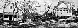
Jericho Hotel, circa 1890
Location map of Cumberland County, New Jersey.svg
Red pog.svg
Jericho
Location in Cumberland County (Inset: Cumberland County in New Jersey)
USA New Jersey location map.svg
Red pog.svg
Jericho
Jericho (New Jersey)
Usa edcp location map.svg
Red pog.svg
Jericho
Jericho (the United States)
Coordinates: 39°28′12″N75°21′06″W / 39.47000°N 75.35167°W / 39.47000; -75.35167 Coordinates: 39°28′12″N75°21′06″W / 39.47000°N 75.35167°W / 39.47000; -75.35167
Country Flag of the United States.svg  United States
State Flag of New Jersey.svg  New Jersey
County Cumberland
Township Stow Creek
Elevation
[1]
9 m (30 ft)
Time zone UTC-5 (Eastern (EST))
  Summer (DST) UTC-4 (EDT)
GNIS feature ID877447 [1]

Jericho is a community located within Stow Creek Township, in Cumberland County, New Jersey, United States. [1] [2] [3]

Stow Creek, a tributary of the Delaware River, flows through the settlement, and a pond and dam are located there. [4] [5]

Jericho was at one time an important mill town in the history of Cumberland and Salem counties. [6]

History

Originally called "Gravelly Run", the settlement began to flourish in 1680 when John Brick purchased 1,000 acres (400 ha) of land bordering Stow Creek, and erected sawmills and gristmills. [6] [7] The Jericho Hotel was built, and in 1818, a distillery located in Jericho was converted into a woolen factory. [6]

The geologic area around Jericho contains Miocene epoch marl, and it is rich with fossils. [8] In the early 1800s, farmers near Jericho began using the mudlike marl found along Stow Creek as fertilizer, and commercial marl pits were built. [6]

Related Research Articles

<span class="mw-page-title-main">Greenwich Township, Cumberland County, New Jersey</span> Township in Cumberland County, New Jersey, United States

Greenwich Township is the westernmost township in Cumberland County, New Jersey, United States. As of the 2010 United States Census, the township's population was 804, reflecting a decline of 43 (−5.1%) from the 847 counted in the 2000 Census, which had in turn declined by 64 (−7.0%) from the 911 counted in the 1990 Census. It is part of the Vineland–Millville–Bridgeton Primary Metropolitan Statistical Area for statistical purposes.

<span class="mw-page-title-main">Stow Creek Township, New Jersey</span> Township in Cumberland County, New Jersey, United States

Stow Creek Township is a township in Cumberland County, New Jersey, United States. It is part of the Vineland-Millville-Bridgeton Primary Metropolitan Statistical Area for statistical purposes. As of the 2010 United States Census, the township had a total population of 1,431, reflecting an increase of 2 (+0.1%) from the 1,429 counted in the 2000 Census, which had in turn declined by 8 (−0.6%) from the 1,437 counted in the 1990 Census.

<span class="mw-page-title-main">Cumberland River</span> River in Kentucky and Tennessee, United States

The Cumberland River is a major waterway of the Southern United States. The 688-mile-long (1,107 km) river drains almost 18,000 square miles (47,000 km2) of southern Kentucky and north-central Tennessee. The river flows generally west from a source in the Appalachian Mountains to its confluence with the Ohio River near Paducah, Kentucky, and the mouth of the Tennessee River. Major tributaries include the Obey, Caney Fork, Stones, and Red rivers.

<span class="mw-page-title-main">Oradell Reservoir</span> Reservoir in New Jersey on the Hackensack River

The Oradell Reservoir is a reservoir formed by the Oradell Reservoir Dam on the Hackensack River in Bergen County, New Jersey, USA.

<span class="mw-page-title-main">Greenwood Lake</span> Body of water

Greenwood Lake is an interstate lake approximately seven miles (11 km) long, straddling the border of New York and New Jersey. It is located in the Town of Warwick and the Village of Greenwood Lake, New York and West Milford, New Jersey. It is the source of the Wanaque River.

<span class="mw-page-title-main">Alum Creek (Ohio)</span> River in United States of America

Alum Creek is 58-mile (93 km) long creek that runs north to south in central Ohio. The creek originates in Morrow County and then flows through Delaware County and finally into Franklin County, where it ends at Big Walnut Creek, which drains into the Scioto River. Alum Creek is a source of drinking water for the city of Westerville, Ohio.

<span class="mw-page-title-main">Dowagiac River</span> River in Michigan, United States

The Dowagiac River is a southwesterly flowing 30.9-mile-long (49.7 km) stream in the Lower Peninsula of the U.S. state of Michigan. It is tributary to the St. Joseph River which flows, in turn, into eastern Lake Michigan.

<span class="mw-page-title-main">Presumpscot River</span> River in the United States of America

The Presumpscot River is a 25.8-mile-long (41.5 km) river located in Cumberland County, Maine. It is the main outlet of Sebago Lake. The river provided an early transportation corridor with reliable water power for industrial development of the city of Westbrook and the village of South Windham.

<span class="mw-page-title-main">Whitehouse, New Jersey</span> Unincorporated community in New Jersey, United States

Whitehouse, also spelled White House, is an unincorporated community located within Readington Township in Hunterdon County, New Jersey. The community lies along the former Jersey Turnpike, just west of Mechanicsville. The Whitehouse–Mechanicsville Historic District, which includes historic places in both Whitehouse and Mechanicsville, was added to the National Register of Historic Places on March 17, 2015.

<span class="mw-page-title-main">Fairmount, New Jersey</span> Unincorporated community in New Jersey, United States

Fairmount is an unincorporated community located along County Route 517 in Tewksbury Township of Hunterdon County, New Jersey. The community was first known as Parkersville, named after proprietor James Parker (1725–1797). The southern section of the community is known as Lower Fairmount.

Cumberland is a small unincorporated community located within Maurice River Township in Cumberland County, New Jersey, United States. For statistical purposes, Cumberland and neighboring Hesstown together comprise the Cumberland-Hesstown census-designated place.

<span class="mw-page-title-main">Boyne River (Michigan)</span> River in Michigan, United States

Boyne River is a stream in Northern Michigan, named for the River Boyne in Leinster, Ireland. Together with the north and south branches, the river system has approximately 22 miles (35 km) of mainstream and the water basin drains 40,320 acres (163.2 km2). Boyne River is Lake Charlevoix's second-largest tributary, after the Jordan River.

Indian Creek, also known as Big Indian Creek, is a 51.5-mile-long (82.9 km) tributary of the Fox River in Lee, LaSalle, and DeKalb counties in Illinois.

Roadstown is an unincorporated community located within Stow Creek Township, in Cumberland County, New Jersey, United States.

<span class="mw-page-title-main">Sparkill Creek</span> River in New Jersey, United States

Sparkill Creek, is a tributary of the Hudson River in Rockland County, New York and Bergen County, New Jersey in the United States. It flows through the Sparkill Gap in the Hudson Palisades, which was created by a fault line which provided the only sea-level break in the Palisades.

<span class="mw-page-title-main">Headquarters, New Jersey</span> Unincorporated community in New Jersey, United States

Headquarters is an unincorporated community located within the Amwell Valley of Delaware Township in Hunterdon County, New Jersey. The settlement is centered around the intersection of Zentek Road and County Route 604. It is about 3 miles (4.8 km) from Ringoes to the east and 1 mile (1.6 km) from Sergeantsville to the west. The Headquarters Historic District was listed on the state and national registers of historic places in 2011 and had its boundary increased in 2016.

<span class="mw-page-title-main">Springtown, New Jersey</span> Unincorporated community in New Jersey

Springtown is an unincorporated community in Greenwich Township, in Cumberland County, New Jersey, United States.

<span class="mw-page-title-main">Neepaulakating Creek</span> Tributary of Papakating Creek

Neepaulakating Creek is a 2.4-mile long (3.8 km) tributary of Papakating Creek in Wantage Township in Sussex County, New Jersey in the United States. It is one of three streams feeding the Papakating Creek, a major contributor to the Wallkill River. Although the stream was dammed in the 1950s to create Lake Neepaulin as the focal point of a private residential development, the stream did not receive a name until 2002. Residents chose a name that combined elements of the names "Neepaulin" and "Papakating", and submitted a proposal to the United States Board of Geographic Names. The name was approved in 2004.

<span class="mw-page-title-main">Daigle, Maine</span> Unincorporated community in Maine, United States

Daigle is an unincorporated community in the town of New Canada, in Aroostook County, Maine, United States. It is the only named community in the town.

<span class="mw-page-title-main">Pleasant Valley, Warren County, New Jersey</span> Unincorporated community in New Jersey, United States

Pleasant Valley is an unincorporated community located in Washington Township, Warren County, New Jersey, west of Washington, along the Pohatcong Creek. The hamlet was built around a mill on the creek during the mid-18th century. The Pleasant Valley Historic District, encompassing the village, is listed on the state and national registers of historic places.

References

  1. 1 2 3 U.S. Geological Survey Geographic Names Information System: Jericho
  2. Locality Search, State of New Jersey. Accessed December 28, 2014.
  3. Gannett, Henry (January 28, 1895). "A Geographic Dictionary of New Jersey". U.S. Government Printing Office via Google Books.
  4. U.S. Geological Survey Geographic Names Information System: Jericho Pond
  5. U.S. Geological Survey Geographic Names Information System: Jericho Pond Dam
  6. 1 2 3 4 Harrison, Charles (2013). Cumberland County, New Jersey: 265 Years of History. History Press. pp. 144, 145. ISBN   9781609497767.
  7. Shourds, Thomas (1876). History and Genealogy of Fenwick's Colony, New Jersey. G.F. Nixon. p. 165.
  8. Dana, James Dwight (1880). Manual of Geology: Treating of the Principles of the Science with Special Reference to American Geological History. Ivison, Blakeman, Taylor and Company. p. 495.