
Maurice River Township is the easternmost township in Cumberland County, in the U.S. state of New Jersey. The township, and all of Cumberland County, is part of the Vineland-Bridgeton metropolitan statistical area for statistical purposes, and of the Philadelphia-Wilmington-Camden, PA-NJ-DE-MD combined statistical area, also known as the Delaware Valley or Philadelphia metropolitan area. As of the 2020 United States census, the township's population was 6,218, a decrease of 1,758 (−22.0%) from the 2010 census count of 7,976, which in turn reflected an increase of 1,048 (+15.1%) from the 6,928 counted in the 2000 census.

The Maurice River ) is a tributary of Delaware Bay in Salem County and Cumberland County, New Jersey in the United States. The river was named for Maurice, Prince of Orange.

Bridgeport is a census-designated place (CDP) and unincorporated community that is part of Logan Township, in Gloucester County, in the U.S. state of New Jersey. At the 2020 United States census, the population of the CDP was 389. in the 2010 census, the population was 504.

Port Elizabeth is an unincorporated community and census-designated place (CDP) located within Maurice River Township in Cumberland County, in the U.S. state of New Jersey. The area is served as United States Postal Service ZIP Code 08348.
Manantico Creek, spelled Menantico on federal maps, is an 11.1-mile-long (17.9 km) tributary of the Maurice River in Cumberland County, New Jersey in the United States.

Papakating Creek is a 20.1-mile-long (32.3 km) tributary of the Wallkill River located in Frankford and Wantage townships in Sussex County, New Jersey in the United States. The creek rises in a small swamp located beneath the eastern face of Kittatinny Mountain in Frankford and its waters join the Wallkill to the east of Sussex borough.
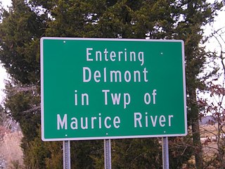
Delmont is an unincorporated community and census-designated place (CDP) located within Maurice River Township, in Cumberland County, in the U.S. state of New Jersey. The area is served as United States Postal Service ZIP Code 08314. It was first listed as a CDP in the 2020 census with a population of 122.
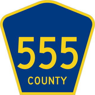
County Route 555 is a county highway in the U.S. state of New Jersey. The highway extends 34.20 miles (55.04 km) from Port Norris Road in Downe Township to Black Horse Pike in Washington Township in Gloucester County.

New Jersey is a state within the United States of America that lies on the north eastern edge of the North American continent. It shares a land border with the state of New York along the north, ratified by both states after the New York – New Jersey Line War, which is its only straight line border. New Jersey is slightly larger than the country of Kuwait.

Whitehouse, also spelled White House, is an unincorporated community located within Readington Township in Hunterdon County, New Jersey. The community lies along the former Jersey Turnpike, just west of Mechanicsville. The Whitehouse–Mechanicsville Historic District, which includes historic places in both Whitehouse and Mechanicsville, was added to the National Register of Historic Places on March 17, 2015.

Crosswicks is an unincorporated community and census-designated place (CDP) located along the Crosswicks Creek in the northern part of Chesterfield Township in Burlington County in the U.S. state of New Jersey. The area is served as United States Postal Service ZIP Code 08515.

Mauricetown is a census-designated place and unincorporated community that is part of Commercial Township in Cumberland County, in the U.S. state of New Jersey.
Dorchester is an unincorporated community located within Maurice River Township, in Cumberland County, in the U.S. state of New Jersey. The area is served as United States Postal Service ZIP Code 08316.

Heislerville is an unincorporated community and census-designated place (CDP) that is part of Maurice River Township in Cumberland County in the U.S. state of New Jersey. It was named after the Heisler family, prominent members of the Methodist Episcopal Church established here in 1828.
Leesburg is an unincorporated community and census-designated place (CDP) located within Maurice River Township in Cumberland County, in the U.S. state of New Jersey. The area is served as United States Postal Service ZIP Code 08327.
Cumberland is a small unincorporated community located within Maurice River Township in Cumberland County, in the U.S. state of New Jersey. For statistical purposes, Cumberland and neighboring Hesstown together comprise the Cumberland-Hesstown census-designated place.
Citizens United to Protect the Maurice River and Its Tributaries, Inc., or "CU", is a 501(c)(3) (nonprofit) regional watershed organization. It was founded in 1979 and incorporated in 1986.

Jericho is a community located within Stow Creek Township, in Cumberland County, New Jersey, United States.

Neepaulakating Creek is a 2.4-mile long (3.8 km) tributary of Papakating Creek in Wantage Township in Sussex County, New Jersey in the United States. It is one of three streams feeding the Papakating Creek, a major contributor to the Wallkill River. Although the stream was dammed in the 1950s to create Lake Neepaulin as the focal point of a private residential development, the stream did not receive a name until 2002. Residents chose a name that combined elements of the names "Neepaulin" and "Papakating", and submitted a proposal to the United States Board of Geographic Names. The name was approved in 2004.
Othello is an unincorporated community and census-designated place (CDP) located within Greenwich Township, Cumberland County, in the U.S. state of New Jersey. It was first listed as a CDP in the 2020 census with a population of 132.


