Cumberland County is a coastal county located on the Delaware Bay in the Southern Shore Region of the U.S. state of New Jersey. As of the 2020 census, the county was the state's 16th-most-populous county, with a population of 154,152, a decrease of 2,746 (−1.8%) from the 2010 census count of 156,898. Its county seat is Bridgeton. Cumberland County is named for Prince William, Duke of Cumberland. The county was formally created from portions of Salem County on January 19, 1748. The county is part of the South Jersey region of the state.

Deerfield Township is a township in Cumberland County, in the U.S. state of New Jersey. It is part of the Vineland--Bridgeton metropolitan statistical area, which encompasses those cities and all of Cumberland County for statistical purposes and which constitutes a part of the Delaware Valley. As of the 2020 United States census, the township's population was 3,136, an increase of 17 (+0.5%) from the 2010 census count of 3,119, which in turn reflected an increase of 192 (+6.6%) from the 2,927 counted in the 2000 census.

Fairfield Township is a township in Cumberland County, in the U.S. state of New Jersey. It is part of the Vineland-Bridgeton metropolitan statistical area, which encompasses all of Cumberland County for statistical purposes and which constitutes a part of the Delaware Valley. As of the 2020 United States census, the township's population was 5,546, a decrease of 749 (−11.9%) from the 2010 census count of 6,295, which in turn reflected an increase of 12 (+0.2%) from the 6,283 counted in the 2000 census.

Greenwich Township is the westernmost township in Cumberland County, in the U.S. state of New Jersey. As of the 2020 United States census, the township's population was 771, a decrease of 33 (−4.1%) from the 2010 census count of 804, which in turn reflected a decline of 43 (−5.1%) from the 847 counted in the 2000 census. It is part of the Vineland-Bridgeton metropolitan statistical area, which encompasses those cities and all of Cumberland County for statistical purposes and which constitutes a part of the Delaware Valley.

Shiloh is a borough in Cumberland County, in the U.S. state of New Jersey. It is part of the Vineland–Bridgeton metropolitan statistical area for statistical purposes. As of the 2020 United States census, the borough's population was 444, a decrease of 72 (−14.0%) from the 2010 census count of 516, which in turn reflected a decline of 18 (−3.4%) from the 534 counted in the 2000 census.

Stow Creek Township is a township in Cumberland County, in the U.S. state of New Jersey. It is part of the Vineland-Bridgeton metropolitan statistical area for statistical purposes. As of the 2020 United States census, the township's population was 1,312, a decrease of 119 (−8.3%) from the 2010 census count of 1,431, which in turn reflected an increase of two people (+0.1%) from the 1,429 counted in the 2000 census.
Upper Deerfield Township is a township in Cumberland County, in the U.S. state of New Jersey. It is part of the Vineland-Bridgeton metropolitan statistical area, which encompasses those cities and all of Cumberland County for statistical purposes and which constitutes a part of the Delaware Valley. As of the 2020 United States census, the township's population was 7,645, a decrease of 15 (−0.2%) from the 2010 census count of 7,660, which in turn reflected an increase of 104 (+1.4%) from the 7,556 counted in the 2000 census.

New Egypt is an unincorporated community and census-designated place (CDP) located within Plumsted Township, in Ocean County, in the U.S. state of New Jersey. As of the 2010 United States Census, the CDP's population was 2,512. The community is located at the trijunction of Burlington County, Monmouth County and Ocean counties.
South Jersey comprises the southern portion of the U.S. state of New Jersey. It is located between Pennsylvania and the lower Delaware River to its west, the Atlantic Ocean to its east, Delaware to its south, and Central Jersey or North Jersey to its north, depending on the definition of North Jersey.

Johnsonburg is an unincorporated community and census-designated place (CDP) located within Frelinghuysen Township in Warren County, in the U.S. state of New Jersey, that was created as part of the 2010 United States Census. As of the 2020 Census, the CDP's population was 381, up from 101 in the 2010 Census.

Stewartsville is an unincorporated community and census-designated place (CDP) located within Greenwich Township in Warren County, in the U.S. state of New Jersey, that was created as part of the 2010 United States Census. As of the 2010 Census, the CDP's population was 349.
Cumberland is a small unincorporated community located within Maurice River Township in Cumberland County, in the U.S. state of New Jersey. For statistical purposes, Cumberland and neighboring Hesstown together comprise the Cumberland-Hesstown census-designated place.

Bethel AME Church, now known as the Central Pennsylvania African American Museum, is a historic African Methodist Episcopal church at 119 North 10th Street in Reading, Berks County, Pennsylvania. It was originally built in 1837, and is a 2½-storey brick and stucco building with a gable roof. It was rebuilt about 1867–1869, and remodeled in 1889. It features a three-storey brick tower with a pyramidal roof topped by a finial. The church is known to have housed fugitive slaves and the congregation was active in the Underground Railroad. The church is now home to a museum dedicated to the history of African Americans in Central Pennsylvania.

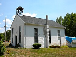
Bethel African Methodist Episcopal Church is a historic African Methodist Episcopal Church in Springtown, New Jersey, United States. The church was part of two free negro communities, Othello and Springtown, established by local Quaker families, like the Van Leer Family. The congregation was established in 1810 in Greenwich Township as the African Methodist Society and joined the African Methodist Episcopal Church in 1817. A previous church building was burned down in the 1830s in an arson incident and the current structure was built between 1838 and 1841.

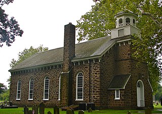
Mount Zion African Methodist Episcopal Church and Mount Zion Cemetery is a historic church and cemetery located at 172 Garwin Road in Woolwich Township, New Jersey, United States. The church was a stop on the Greenwich Line of the Underground Railroad through South Jersey operated by Harriet Tubman for 10 years. The church provided supplies and shelter to runaway slaves on their way to Canada from the South. The church and cemetery were part of the early 19th-century free negro settlement sponsored by Quakers known as Small Gloucester.
Gouldtown is an unincorporated community and census-designated place (CDP) in Cumberland County, in the U.S. state of New Jersey. It is in the northwestern part of the county, in the northeast part of Fairfield Township, and it is bordered to the west by the city of Bridgeton, the county seat. New Jersey Route 49 runs through the community, leading east 8 miles (13 km) to Millville and west through Bridgeton 19 miles (31 km) to Salem.

Marshalltown is an unincorporated community located within Mannington Township, in Salem County, New Jersey. It has also been known as Frogtown.
Othello is an unincorporated community and census-designated place (CDP) located within Greenwich Township, Cumberland County, in the U.S. state of New Jersey. It was first listed as a CDP in the 2020 census with a population of 132.

Old Bridge, also known as the Historic Village of Old Bridge, is an unincorporated community located within East Brunswick in Middlesex County, in the U.S. state of New Jersey. It is on the South River, a tributary of the Raritan River. The community is named after the first bridge built here to cross the river, the South River Bridge. After other bridges were built crossing the river, it became known as the Old Bridge. The Old Bridge Historic District, encompassing much of the village, is listed on the state and national registers of historic places.