Milmay, New Jersey | |
|---|---|
 Southbound CR 557 in Milmay | |
| Coordinates: 39°26′21″N74°51′25″W / 39.43917°N 74.85694°W | |
| Country | |
| State | |
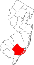
| County | Cumberland, Atlantic |
| Townships | Buena Vista Maurice River |
| Area | |
• Total | 8.22 sq mi (21.29 km2) |
| • Land | 8.20 sq mi (21.25 km2) |
| • Water | 0.012 sq mi (0.03 km2) |
| Elevation | 98 ft (30 m) |
| Population | |
• Total | 919 |
| • Density | 112.0/sq mi (43.24/km2) |
| Time zone | UTC−05:00 (Eastern (EST)) |
| • Summer (DST) | UTC−04:00 (EDT) |
| ZIP Code | 08340 |
| Area codes | 609, 640 |
| FIPS code | 34-46710 [3] |
| GNIS feature ID | 878393 [4] |


Milmay is an unincorporated community and census-designated place (CDP) [5] located mostly within Buena Vista Township, in Atlantic County, in the U.S. state of New Jersey. [6] Part of the CDP extends southwest into Maurice River Township in Cumberland County.
Contents
Milmay is located at the junction of County Routes 552 and 557 7.7 miles (12.4 km) southeast of Buena. [7] Milmay has a post office with ZIP Code 08340. [8] [9]