Pomona, New Jersey | |
---|---|
![]() Neighboring communities | |
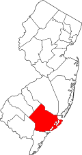
![]() Left: Map highlighting Pomona within Atlantic County: Right: location of Atlantic County in New Jersey. | |
Coordinates: 39°28′07″N74°33′00″W / 39.468722°N 74.550112°W [1] [2] | |
Country | ![]() |
State | ![]() |
County | Atlantic |
Township | Galloway |
Area | |
• Total | 2.79 sq mi (7.21 km2) |
• Land | 2.79 sq mi (7.21 km2) |
• Water | 0.00 sq mi (0.00 km2) 0.00% |
Elevation | 56 ft (17 m) |
Population | |
• Total | 7,416 |
• Density | 2,662.8/sq mi (1,028.1/km2) |
Time zone | UTC−05:00 (Eastern (EST)) |
• Summer (DST) | UTC−04:00 (EDT) |
ZIP Code | 08240 [6] |
Area code | 609 |
FIPS code | 34-60030 [1] [7] [8] |
GNIS feature ID | 02389693 [1] [9] |
Pomona is an unincorporated community and census-designated place (CDP) [10] located within Galloway Township, in Atlantic County, in the U.S. state of New Jersey. [11] [12] [13] As of the 2010 United States Census, the CDP's population was 7,124. [14] [15] The area is served as United States Postal Service ZIP Code 08240. [6]
Locally, the name "Pomona" is loosely used also to refer to areas adjacent to Pomona proper, including adjoining portions of Hamilton Township and Egg Harbor Township in the vicinity of the Atlantic City International Airport.[ citation needed ]
Pomona was often described as the home to Stockton University,[ citation needed ] since the mailing address for the college was a post-office box located in the Pomona Post Office. [16] In 2011, the university changed its mailing address to its main campus (using the street Vera King Farris Drive, Galloway Township, New Jersey). [17]
According to the U.S. Census Bureau, the Pomona CDP had a total area of 2.797 square miles (7.24 km2), all of which was land. [1] [2]
Census | Pop. | Note | %± |
---|---|---|---|
1990 | 2,624 | — | |
2000 | 4,019 | 53.2% | |
2010 | 7,124 | 77.3% | |
2020 | 7,416 | 4.1% | |
Population sources 1990-2010 [13] 2000 [18] 2010 [14] 2020 [5] |
The 2010 United States census counted 7,124 people, 2,107 households, and 1,601 families in the CDP. The population density was 2,547.0 people per square mile (983.4 people/km2). There were 2,202 housing units at an average density of 787.3 units per square mile (304.0 units/km2). The racial makeup was 57.99% (4,131) White, 10.64% (758) Black or African American, 0.44% (31) Native American, 22.11% (1,575) Asian, 0.00% (0) Pacific Islander, 5.22% (372) from other races, and 3.61% (257) from two or more races. Hispanic or Latino of any race were 13.22% (942) of the population. [14]
Of the 2,107 households, 43.4% had children under the age of 18; 58.4% were married couples living together; 12.0% had a female householder with no husband present and 24.0% were non-families. Of all households, 19.7% were made up of individuals and 12.2% had someone living alone who was 65 years of age or older. The average household size was 3.19 and the average family size was 3.68. [14]
26.6% of the population were under the age of 18, 8.9% from 18 to 24, 25.7% from 25 to 44, 24.5% from 45 to 64, and 14.3% who were 65 years of age or older. The median age was 37.4 years. For every 100 females, the population had 86.6 males. For every 100 females ages 18 and older there were 82.3 males. [14]
At the 2000 census, [7] there were 4,019 people, 1,297 households and 1,002 families living in the CDP. The population density was 554.2 people/km2 (1,435 people/sq mi). There were 1,357 housing units at an average density of 187.1 units/km2 (485 units/sq mi). The racial makeup of the CDP was 74.15% White, 8.04% African American, 0.35% Native American, 11.99% Asian, 0.02% Pacific Islander, 3.56% from other races, and 1.89% from two or more races. Hispanic or Latino of any race were 7.49% of the population. [18]
There were 1,297 households, of which 45.7% had children under the age of 18 living with them, 61.0% were married couples living together, 10.9% had a female householder with no husband present, and 22.7% were non-families. 18.0% of all households were made up of individuals, and 8.8% had someone living alone who was 65 years of age or older. The average household size was 3.05 and the average family size was 3.47. [18]
30.4% of the population were under the age of 18, 7.3% from 18 to 24, 34.9% from 25 to 44, 18.9% from 45 to 64, and 8.5% who were 65 years of age or older. The median age was 34 years. For every 100 females, there were 95.4 males. For every 100 females age 18 and over, there were 88.4 males. [18]
The median household income was $52,796, and the median family income was $56,846. Males had a median income of $35,554 versus $29,453 for females. The per capita income for the CDP was $18,182. About 2.3% of families and 4.6% of the population were below the poverty line, including 3.3% of those under age 18 and 15.9% of those age 65 or over. [18]
Galloway Township Public Schools operates schools for grades K-8 while the Greater Egg Harbor Regional High School District operates area high schools. [19]
Galloway Township residents, including those of Pomona, are zoned to Absegami High School. [20]
Assumption Regional Catholic School, under the Roman Catholic Diocese of Camden, was previously in Pomona, [21] but in September 2007 moved to another campus elsewhere in the township. [22]
P.O. Box 195 Pomona, NJ 08240
101 Vera King Farris Drive Galloway, NJ 08205-9441
276 West White Horse Pike Pomona, New Jersey
146 South Pitney Road Galloway, New Jersey 08205- redirected from assumptionregionalschool.org