Related Research Articles
Rodinia was a Mesoproterozoic and Neoproterozoic supercontinent that assembled 1.26–0.90 billion years ago (Ga) and broke up 750–633 million years ago (Ma). Valentine & Moores 1970 were probably the first to recognise a Precambrian supercontinent, which they named "Pangaea I." It was renamed "Rodinia" by McMenamin & McMenamin 1990, who also were the first to produce a plate reconstruction and propose a temporal framework for the supercontinent.

Columbia, also known as Nuna or Hudsonland, is a hypothetical ancient supercontinent. It was first proposed by John J.W. Rogers and M. Santosh in 2002 and is thought to have existed approximately 2,500 to 1,500 million years ago (Ma), in the Paleoproterozoic era. The assembly of the supercontinent was likely completed during global-scale collisional events from 2,100 to 1,800 Ma.

The geology of Antarctica covers the geological development of the continent through the Archean, Proterozoic and Phanerozoic eons.
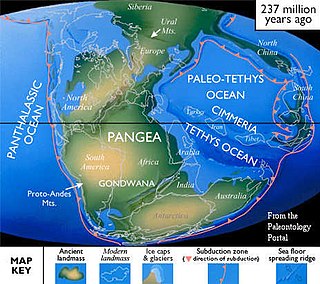
Cimmeria was an ancient continent, or, rather, a string of microcontinents or terranes, that rifted from Gondwana in the Southern Hemisphere and was accreted to Eurasia in the Northern Hemisphere. It consisted of parts of present-day Turkey, Iran, Afghanistan, Pakistan, Tibet, China, Myanmar, Thailand, and Malaysia. Cimmeria rifted from the Gondwanan shores of the Paleo-Tethys Ocean during the Early Permian and as the Neo-Tethys Ocean opened behind it, during the Permian, the Paleo-Tethys closed in front of it. Because the different chunks of Cimmeria drifted northward at different rates, a Meso-Tethys Ocean formed between the different fragments during the Cisuralian. Cimmeria rifted off Gondwana from east to west, from Australia to the eastern Mediterranean. It stretched across several latitudes and spanned a wide range of climatic zones.
The Karoo and Ferrar Large Igneous Provinces (LIPs) are two large igneous provinces in Southern Africa and Antarctica respectively, collectively known as the Karoo-Ferrar, Gondwana, or Southeast African LIP, associated with the initial break-up of the Gondwana supercontinent at c.183Ma. Its flood basalt mostly covers South Africa and Antarctica but portions extend further into southern Africa and into South America, India, Australia and New Zealand.

Gondwana was a large landmass, sometimes referred to as a supercontinent. The remnants of Gondwana make up around two-thirds of today's continental area, including South America, Africa, Antarctica, Australia, Zealandia, Arabia, and the Indian Subcontinent.

Ur is a hypothetical supercontinent that formed in the Archean eon around 3.1 billion years ago (Ga). In a reconstruction by Rogers, Ur is half a billion years older than Arctica and, in the early period of its existence, probably the only continent on Earth, making it a supercontinent despite probably being smaller than present-day Australia. In more recent works geologists often refer to both Ur and other proposed Archaean continental assemblages as supercratons. Ur can, nevertheless, be half a billion years younger than Vaalbara, but the concepts of these two early cratonic assemblages are incompatible.
The Erebus hotspot is a volcanic hotspot responsible for the high volcanic activity on Ross Island in the western Ross Sea of Antarctica. Its current eruptive zone, Mount Erebus, has erupted continuously since its discovery in 1841. Magmas of the Erebus hotspot are similar to those erupted from hotspots at the active East African Rift in eastern Africa. Mount Bird at the northernmost end of Ross Island and Mount Terror at its eastern end are large basaltic shield volcanoes that have been potassium-argon dated 3.8–4.8 and 0.8–1.8 million years old.

The East Antarctic Shield or Craton is a cratonic rock body that covers 10.2 million square kilometers or roughly 73% of the continent of Antarctica. The shield is almost entirely buried by the East Antarctic Ice Sheet that has an average thickness of 2200 meters but reaches up to 4700 meters in some locations. East Antarctica is separated from West Antarctica by the 100–300 kilometer wide Transantarctic Mountains, which span nearly 3,500 kilometers from the Weddell Sea to the Ross Sea. The East Antarctic Shield is then divided into an extensive central craton that occupies most of the continental interior and various other marginal cratons that are exposed along the coast.

The Lhasa terrane is a terrane, or fragment of crustal material, sutured to the Eurasian Plate during the Cretaceous that forms present-day southern Tibet. It takes its name from the city of Lhasa in the Tibet Autonomous Region, China. The northern part may have originated in the East African Orogeny, while the southern part appears to have once been part of Australia. The two parts joined, were later attached to Asia, and then were impacted by the collision of the Indian Plate that formed the Himalayas.

The Famatinian orogeny is an orogeny that predates the rise of the Andes and that took place in what is now western South America during the Paleozoic, leading to the formation of the Famatinian orogen also known as the Famatinian belt. The Famatinian orogeny lasted from the Late Cambrian to at least the Late Devonian and possibly the Early Carboniferous, with orogenic activity peaking about 490 to 460 million years ago. The orogeny involved metamorphism and deformation in the crust and the eruption and intrusion of magma along a Famatinian magmatic arc that formed a chain of volcanoes. The igneous rocks of the Famatinian magmatic arc are of calc-alkaline character and include gabbros, tonalites, granodiorites and trondhjemites. The youngest igneous rocks of the arc are granites.

The Terra Australis Orogen (TAO) was a late Neoproterozoic- to Paleozoic-age accretionary orogen that ringed the ancient, active southern margin of the supercontinents Rodinia and later Pannotia. This vast orogenic belt stretched for c. 18,000 km (11,000 mi) along-strike and involved, from west to east, landmasses belonging to the modern-day Andean margin of South America, the South African Cape, West Antarctica, Victoria Land in East Antarctica, Eastern Australia, Tasmania, and New Zealand. The formation of the Terra Australis Orogen is associated with the breakup of Rodinia at the end of the Neoproterozoic Era and the creation of Panthalassa, the paleo-Pacific Ocean, and it was succeeded by the Gondwanide orogeny with the formation of the supercontinent Pangea in the middle Paleozoic Era.

The Gondwanide orogeny was an orogeny active in the Permian that affected parts of Gondwana that are by current geography now located in southern South America, South Africa, Antarctica, Australia and New Guinea. The zone of deformation in Argentina extends as a belt south and west of the cratonic nucleus of Río de la Plata–Pampia. The deformation of the orogeny is visible in the Sierra de la Ventana mountains in Argentina and the Cape Fold Belt in South Africa. The Gondwanide orogeny might have been linked with the roughly contemporary San Rafael orogeny of western Argentina.

Terry Jean Wilson is an international leader in the study of present-day tectonics in Antarctica. She has led large, international efforts, such as Polar Earth Observing Network (POLENET), to investigate the interactions between the Earth's crust and the cryosphere in Antarctica.

Rosemary Anne Askin, also known as Rosemary Askin Cully, is a New Zealand geologist specialising in Antarctic palynology. She was a trailblazer for women in Antarctic science, becoming the first New Zealand woman to undertake her own research programme in Antarctica in 1970.

Lois M. Jones was an American geochemist who led the first all-woman science team to Antarctica in 1969. They were also the first women to reach the South Pole. Jones was well regarded for her contribution to geological research in the McMurdo Dry Valleys, one of the few ice-free areas of Antarctica, and published many papers and abstracts.

Patagonia comprises the southernmost region of South America, portions of which lie on either side of the Argentina-Chile border. It has traditionally been described as the region south of the Rio, Colorado, although the physiographic border has more recently been moved southward to the Huincul fault. The region's geologic border to the north is composed of the Rio de la Plata craton and several accreted terranes comprising the La Pampa province. The underlying basement rocks of the Patagonian region can be subdivided into two large massifs: the North Patagonian Massif and the Deseado Massif. These massifs are surrounded by sedimentary basins formed in the Mesozoic that underwent subsequent deformation during the Andean orogeny. Patagonia is known for its vast earthquakes and the damage they cause.
The geology of Argentina includes ancient Precambrian basement rock affected by the Grenville orogeny, sediment filled basins from the Mesozoic and Cenozoic as well as newly uplifted areas in the Andes.
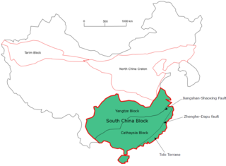
The South China Craton or South China Block is one of the Precambrian continental blocks in China. It is traditionally divided into the Yangtze Block in the NW and the Cathaysia Block in the SE. The Jiangshan–Shaoxing Fault represents the suture boundary between the two sub-blocks. Recent study suggests that the South China Block possibly has one more sub-block which is named the Tolo Terrane. The oldest rocks in the South China Block occur within the Kongling Complex, which yields zircon U–Pb ages of 3.3–2.9 Ga.

The geology of the Ellsworth Mountains, Antarctica, is a rock record of continuous deposition that occurred from the Cambrian to the Permian periods, with basic igneous volcanism and uplift occurring during the Middle to Late Cambrian epochs, deformation occurring in the Late Permian period or early Mesozoic era, and glacier formation occurring in the Cretaceous period and Cenozoic era. The Ellsworth Mountains are located within West Antarctica at 79°S, 85°W. In general, it is made up of mostly rugged and angular peaks such as the Vinson Massif, the highest mountain in Antarctica.
References
- 1 2 3 4 5 6 Polar, Anne GrunowThe Ohio State University | OSU · Byrd; PhD, Climate Research Center 29 56 ·. "Anne Grunow | PhD | The Ohio State University, OH | OSU | Byrd Polar and Climate Research Center". ResearchGate. Retrieved 2018-11-04.
{{cite web}}: CS1 maint: numeric names: authors list (link) - 1 2 3 4 5 6 Writer, MICHELLE BRUNETTI POST Staff. "Galloway Township native has Antarctic peak named for her". Press of Atlantic City. Retrieved 2018-11-04.
- 1 2 3 4 5 6 Grunow, Anne. "Anne Grunow Linkedin". Linkedin. Retrieved 2018-11-04.
- 1 2 "Global Change Master Directory (GCMD)". gcmd.nasa.gov. Retrieved 2018-11-05.[ dead link ]
- 1 2 University, © 2018 The Ohio State (2018-09-07). "The coolest place on campus". The Ohio State University. Retrieved 2018-11-05.
{{cite news}}: CS1 maint: numeric names: authors list (link) - ↑ "Anne Grunow". Byrd Polar and Climate Research Center. 2014-10-28. Retrieved 2018-11-04.
- ↑ "Geological Society of America - 2003 Day Medal - Citation & Response". www.geosociety.org. Retrieved 2018-11-05.
- 1 2 Grunow, Anne (1997). "Gondwana assembly: the view from southern Africa and east Gondwana". Journal of African Earth Sciences. 23 (3): 263. Bibcode:1997JGeo...23..263W. doi:10.1016/S0264-3707(96)00048-8.
- 1 2 3 Wilson, T.J.; Grunow, A.M.; Hanson, R.E. (1997-05-01). "Gondwana assembly: The view from Southern Africa and East Gondwana". Journal of Geodynamics. 23 (3–4): 263–286. Bibcode:1997JGeo...23..263W. doi:10.1016/S0264-3707(96)00048-8. ISSN 0264-3707.
- ↑ "Anne Grunow". Byrd Polar and Climate Research Center. 2014-10-28. Retrieved 2018-11-05.
- 1 2 3 Grunow, Anne; Hanson, Richard; Wilson, Terry (1996). "Were aspects of Pan-African deformation linked to Iapetus opening?". Geology. 24 (12): 1063. Bibcode:1996Geo....24.1063G. doi:10.1130/0091-7613(1996)024<1063:WAOPAD>2.3.CO;2. ISSN 0091-7613.
- 1 2 3 Encarnación, John; Grunow, Anne (December 1996). "Changing magmatic and tectonic styles along the paleo-Pacific margin of Gondwana and the onset of early Paleozoic magmatism in Antarctica". Tectonics. 15 (6): 1325–1341. Bibcode:1996Tecto..15.1325E. doi:10.1029/96tc01484. ISSN 0278-7407.
- 1 2 "Global Change Master Directory (GCMD)". gcmd.nasa.gov. Archived from the original on 2004-09-28. Retrieved 2018-11-05.
- ↑ "The Antarctic Sun: News about Antarctica - Almost Like Being There". antarcticsun.usap.gov. Retrieved 2018-11-06.
- ↑ M., Grunow, A. (1993). "New paleomagnetic data from the Antarctic Peninsula and their tectonic implications". Journal of Geophysical Research. 98 (B8): 13815–13833. Bibcode:1993JGR....9813815G. doi:10.1029/93jb01089. ISSN 0148-0227.
{{cite journal}}: CS1 maint: multiple names: authors list (link) - ↑ "Implications for Gondwana of new Ordovician paleomagnetic data from igneous rocks in southern Victoria Land, East Antarctica" . Retrieved 2018-11-06.
- ↑ "BPCRC Award and Scholarship Ceremony". Byrd Polar and Climate Research Center. 2017-11-30. Retrieved 2018-11-05.