
Antarctic Circumpolar Current (ACC) is an ocean current that flows clockwise from west to east around Antarctica. An alternative name for the ACC is the West Wind Drift. The ACC is the dominant circulation feature of the Southern Ocean and has a mean transport estimated at 100–150 Sverdrups, or possibly even higher, making it the largest ocean current. The current is circumpolar due to the lack of any landmass connecting with Antarctica and this keeps warm ocean waters away from Antarctica, enabling that continent to maintain its huge ice sheet.

The Antarctic is a polar region around Earth's South Pole, opposite the Arctic region around the North Pole.

The Ross Sea is a deep bay of the Southern Ocean in Antarctica, between Victoria Land and Marie Byrd Land and within the Ross Embayment, and is the southernmost sea on Earth. It derives its name from the British explorer James Clark Ross who visited this area in 1841. To the west of the sea lies Ross Island and Victoria Land, to the east Roosevelt Island and Edward VII Peninsula in Marie Byrd Land, while the southernmost part is covered by the Ross Ice Shelf, and is about 200 miles (320 km) from the South Pole. Its boundaries and area have been defined by the New Zealand National Institute of Water and Atmospheric Research as having an area of 637,000 square kilometres (246,000 sq mi).

Marie Byrd Land (MBL) is an unclaimed region of Antarctica. With an area of 1,610,000 km2 (620,000 sq mi), it is the largest unclaimed territory on Earth. It was named after the wife of American naval officer Richard E. Byrd, who explored the region in the early 20th century.
Mount Moulton is a 40-kilometre-long (25 mi) complex of ice-covered shield volcanoes, standing 25 kilometres (16 mi) east of Mount Berlin in the Flood Range, Marie Byrd Land, Antarctica. It is named for Richard S. Moulton, chief dog driver at West Base. The volcano is of Pliocene age and is presently inactive.

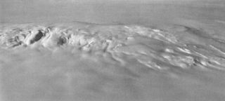
Mount Takahe is a 3,460-metre-high (11,350 ft) snow-covered shield volcano in Marie Byrd Land, Antarctica, 200 kilometres (120 mi) from the Amundsen Sea. It is a c. 30-kilometre-wide (19 mi) mountain with parasitic vents and a caldera up to 8 kilometres (5 mi) wide. Most of the volcano is formed by trachytic lava flows, but hyaloclastite is also found. Snow, ice, and glaciers cover most of Mount Takahe. With a volume of 780 km3 (200 cu mi), it is a massive volcano; the parts of the edifice that are buried underneath the West Antarctic Ice Sheet are probably even larger. It is part of the West Antarctic Rift System along with 18 other known volcanoes.

The West Antarctic Rift System is a series of rift valleys between East and West Antarctica. It encompasses the Ross Embayment, the Ross Sea, the area under the Ross Ice Shelf and a part of Marie Byrd Land in West Antarctica, reaching to the base of the Antarctic Peninsula. It has an estimated length of 3,000 km (1,900 mi) and a width of approximately 700 km (430 mi). Its evolution is due to lithospheric thinning of an area of Antarctica that resulted in the demarcation of East and West Antarctica. The scale and evolution of the rift system has been compared to that of the Basin and Range Province of the Western United States.

Antarctica is Earth's southernmost and least-populated continent. Situated almost entirely south of the Antarctic Circle and surrounded by the Southern Ocean, it contains the geographic South Pole. Antarctica is the fifth-largest continent, being about 40% larger than Europe, and has an area of 14,200,000 km2 (5,500,000 sq mi). Most of Antarctica is covered by the Antarctic ice sheet, with an average thickness of 1.9 km (1.2 mi).
The Erebus hotspot is a volcanic hotspot responsible for the high volcanic activity on Ross Island in the western Ross Sea of Antarctica. Its current eruptive zone, Mount Erebus, has erupted continuously since its discovery in 1841. Magmas of the Erebus hotspot are similar to those erupted from hotspots at the active East African Rift in eastern Africa. Mount Bird at the northernmost end of Ross Island and Mount Terror at its eastern end are large basaltic shield volcanoes that have been potassium-argon dated 3.8–4.8 and 0.8–1.8 million years old.

The East Antarctic Shield or Craton is a cratonic rock body that covers 10.2 million square kilometers or roughly 73% of the continent of Antarctica. The shield is almost entirely buried by the East Antarctic Ice Sheet that has an average thickness of 2200 meters but reaches up to 4700 meters in some locations. East Antarctica is separated from West Antarctica by the 100–300 kilometer wide Transantarctic Mountains, which span nearly 3,500 kilometers from the Weddell Sea to the Ross Sea. The East Antarctic Shield is then divided into an extensive central craton that occupies most of the continental interior and various other marginal cratons that are exposed along the coast.

Robin Elizabeth Bell is Palisades Geophysical Institute (PGI) Lamont Research Professor at Columbia University's Lamont–Doherty Earth Observatory and a past President of the American Geophysical Union (AGU), 2019–2021. Dr. Bell was influential in co-ordinating the 2007 International Polar Year and was the first woman to chair the National Academy of Sciences Polar Research Board. She has made numerous important discoveries with regard to subglacial lakes and ice sheet dynamics, and has a ridge, called Bell Buttress, in Antarctica named after her.
Carlota Escutia Dotti is a Spanish geologist, best known for her work on the geologic evolution of Antarctica and the global role of the Antarctic ice cap. Escutia is based at the Instituto Andaluz de Ciencias de la Tierra, Universidad de Granada and the High Council for Scientific Research (CSIC).

Anna Wåhlin is a Swedish researcher on the Antarctic and the polar seas. She is a professor of physical oceanography at the University of Gothenburg and co-chair of the Southern Ocean Observing System.

Cornelia Lüdecke is a German polar researcher and author. A leading figure in the history of German polar research and the history of meteorology and oceanography, she founded the Expert Group on History of Antarctic Research within the Scientific Committee on Antarctic Research (SCAR), institutionalising historical study and reflection for the Antarctic scientific community. Her books, among others, about the Schwabenland Expedition to Antarctica during the Third Reich and Germans in the Antarctic are milestones in the history of polar research publications.
Laura Crispini is an Italian geologist and an Antarctic researcher. Her areas of expertise are for the Tectonics, Geodynamics and Geological Mapping including the Geology of Antarctica. She has been nominated among 150 International representative of female Antarctic researchers for the SCAR "Celebration of Women in Antarctic Research" wikibomb event. At present she is Professor at the University of Genoa at the Department for Earth Sciences, Envinronment and life (DISTAV).

Frank Jean-Marie Léon Pattyn is a Belgian glaciologist and professor at the Université libre de Bruxelles. He is best known for developing ice-sheet models and leading model intercomparisons.
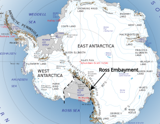
The Ross Embayment is a large region of Antarctica, comprising the Ross Ice Shelf and the Ross Sea, that lies between East and West Antarctica.
Anne Grunow is a senior research scientist at Ohio State University in the Byrd Polar Research Center. She is also the current director of the Polar Rock Repository. Grunow is a geologist specializing in Antarctic tectonics, with her research using methods from geochronology and paleomagnetism.
Sophie Marie Jeanne Nowicki, is Empire Innovation Professor in the Department of Geology of the University at Buffalo. She does research on the Greenland and Antarctic ice sheets, focusing on their connections to global climate and sea level. Before that, she was physical scientist at the Nasa Goddard Space Flight Centre, investigating ice sheet changes.
The Polar Earth Observing Network (POLENET) is a global network involving researchers from 24 nations for the geophysical observation of the polar regions of our planet.
