Mays Landing, New Jersey | |
---|---|
Location in Atlantic County Location in New Jersey | |
Coordinates: 39°27′10″N74°43′26″W / 39.452862°N 74.723936°W | |
Country | United States |
State | New Jersey |
County | Atlantic |
Township | Hamilton |
Named for | Captain George May |
Area | |
• Total | 5.94 sq mi (15.38 km2) |
• Land | 5.64 sq mi (14.61 km2) |
• Water | 0.30 sq mi (0.77 km2) 11.91% |
Elevation | 13 ft (4 m) |
Population | |
• Total | 5,603 |
• Density | 993.1/sq mi (383.4/km2) |
Time zone | UTC−05:00 (Eastern (EST)) |
• Summer (DST) | UTC−04:00 (Eastern (EDT)) |
ZIP Code | 08330 [4] |
Area code | 609 |
FIPS code | 34-44820 [5] [6] [7] |
GNIS feature ID | 02390140 [5] [8] |
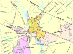
Mays Landing is an unincorporated community and census-designated place (CDP) [9] located within Hamilton Township, Atlantic County, in the U.S. state of New Jersey. [10] [11] [12]
At the 2010 U.S. census, May's Landing's population was 2,135. [13] [14] It is the county seat of Atlantic County, which itself is a part of the South Jersey region of New Jersey. [15]
The community was named for Captain George May, who sailed the Great Egg Harbor River in 1740, and purchased land in the area in 1756. [16] The location was suitable for building ships using local timber and iron from Weymouth foundries. [17] In February 1837, Atlantic County was created and Mays Landing was established as the county seat. The Atlantic County Courthouse was built here in 1838. [18]
Mays Landing Historic District | |
Area | 147 acres (59 ha) |
---|---|
Architectural style | Second Empire, Gothic, Italianate |
NRHP reference No. | 90001245 [19] |
NJRHP No. | 338 [20] |
Significant dates | |
Added to NRHP | August 23, 1990 |
Designated NJRHP | January 11, 1990 |
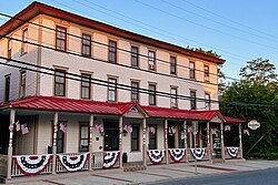
The Mays Landing Historic District is a 147-acre (59 ha) historic district encompassing East and West Main streets and intersecting streets in the community. It was added to the National Register of Historic Places on August 23, 1990, for its significance in architecture, community planning, industry, and politics. The district has 259 contributing buildings, four contributing sites, three contributing structures, and three contributing objects. Contributing buildings include the Mays Landing Presbyterian Church and the Samuel Richards Hotel, which were previously listed individually on the NRHP. The Abbott House features Second Empire architecture. The Champion House has Italianate architecture and Doric columns. The owner, John E. Champion, was once the owner of the Samuel Richards Hotel, then known as the American Hotel. [21]
According to the U.S. Census Bureau, Mays Landing had a total area of 1.885 square miles (4.881 km2), including 1.660 square miles (4.299 km2) of land and 0.225 square miles (0.581 km2) of water (11.91%). [5] [22]
The community is located 20 miles (32 km) west of Atlantic City. [23] The community known as Mizpah is located 5 miles (8 km) west of Mays Landing on U.S. Route 40 but is sometimes considered part of it, with ZIP codes of 08330 and 08342. McKee City is an unincorporated area 4 miles (6 km) east of Mays Landing on US 40.
The climate in this area is characterized by hot, humid summers and generally mild to cool winters. According to the Köppen Climate Classification system, Mays Landing has a humid subtropical climate, abbreviated "Cfa" on climate maps. [24]
Climate data for Atlantic City International Airport, New Jersey (1981–2010 normals, extremes 1943–present) | |||||||||||||
---|---|---|---|---|---|---|---|---|---|---|---|---|---|
Month | Jan | Feb | Mar | Apr | May | Jun | Jul | Aug | Sep | Oct | Nov | Dec | Year |
Record high °F (°C) | 78 (26) | 76 (24) | 87 (31) | 94 (34) | 99 (37) | 106 (41) | 105 (41) | 103 (39) | 99 (37) | 96 (36) | 84 (29) | 77 (25) | 106 (41) |
Mean maximum °F (°C) | 62.6 (17.0) | 64.3 (17.9) | 73.3 (22.9) | 82.4 (28.0) | 88.6 (31.4) | 94.1 (34.5) | 96.6 (35.9) | 95.0 (35.0) | 89.5 (31.9) | 82.1 (27.8) | 72.8 (22.7) | 64.2 (17.9) | 98.0 (36.7) |
Mean daily maximum °F (°C) | 41.5 (5.3) | 44.3 (6.8) | 51.8 (11.0) | 61.7 (16.5) | 71.3 (21.8) | 80.6 (27.0) | 85.5 (29.7) | 83.7 (28.7) | 77.0 (25.0) | 66.6 (19.2) | 56.3 (13.5) | 46.0 (7.8) | 63.9 (17.7) |
Mean daily minimum °F (°C) | 24.5 (−4.2) | 26.4 (−3.1) | 32.7 (0.4) | 41.8 (5.4) | 51.0 (10.6) | 61.2 (16.2) | 66.9 (19.4) | 65.2 (18.4) | 57.4 (14.1) | 45.6 (7.6) | 37.2 (2.9) | 28.4 (−2.0) | 44.9 (7.2) |
Mean minimum °F (°C) | 4.4 (−15.3) | 9.1 (−12.7) | 15.1 (−9.4) | 26.1 (−3.3) | 34.5 (1.4) | 45.7 (7.6) | 53.6 (12.0) | 51.8 (11.0) | 41.7 (5.4) | 29.8 (−1.2) | 20.0 (−6.7) | 10.7 (−11.8) | 2.2 (−16.6) |
Record low °F (°C) | −10 (−23) | −11 (−24) | 2 (−17) | 12 (−11) | 25 (−4) | 37 (3) | 42 (6) | 40 (4) | 32 (0) | 20 (−7) | 10 (−12) | −7 (−22) | −11 (−24) |
Average precipitation inches (mm) | 3.22 (82) | 2.87 (73) | 4.21 (107) | 3.63 (92) | 3.35 (85) | 3.11 (79) | 3.72 (94) | 4.11 (104) | 3.15 (80) | 3.42 (87) | 3.27 (83) | 3.69 (94) | 41.75 (1,060) |
Average snowfall inches (cm) | 4.5 (11) | 6.7 (17) | 1.1 (2.8) | 0.3 (0.76) | 0 (0) | 0 (0) | 0 (0) | 0 (0) | 0 (0) | 0 (0) | 0.2 (0.51) | 3.7 (9.4) | 16.5 (42) |
Average precipitation days (≥ 0.01 in) | 10.1 | 9.5 | 10.3 | 11.6 | 10.6 | 9.4 | 9.2 | 8.7 | 8.0 | 8.1 | 9.3 | 10.2 | 115.0 |
Average snowy days (≥ 0.1 in) | 2.9 | 2.8 | 0.9 | 0.3 | 0 | 0 | 0 | 0 | 0 | 0 | 0.1 | 1.7 | 8.7 |
Average relative humidity (%) | 69.5 | 69.0 | 66.9 | 66.4 | 70.7 | 72.9 | 73.9 | 75.7 | 76.4 | 74.8 | 72.8 | 70.6 | 71.6 |
Mean monthly sunshine hours | 150.8 | 157.9 | 204.5 | 218.9 | 243.9 | 266.2 | 276.3 | 271.3 | 227.6 | 200.5 | 147.4 | 133.8 | 2,499.1 |
Percent possible sunshine | 50 | 53 | 55 | 55 | 55 | 60 | 61 | 64 | 61 | 58 | 49 | 46 | 56 |
Source: NOAA (relative humidity and sun 1961–1990) [25] [26] [27] |
Census | Pop. | Note | %± |
---|---|---|---|
1990 | 2,090 | — | |
2000 | 2,321 | 11.1% | |
2010 | 2,135 | −8.0% | |
2020 | 5,603 | 162.4% | |
Population sources: 1990–2010 [12] 2000 [28] 2010 [13] 2020 [3] |
The 2010 United States census counted 2,135 people, 859 households, and 572 families in the CDP. The population density was 1,286.2 per square mile (496.6/km2). There were 949 housing units at an average density of 571.7 per square mile (220.7/km2). The racial makeup was 88.99% (1,900) White, 5.48% (117) Black or African American, 0.47% (10) Native American, 0.98% (21) Asian, 0.00% (0) Pacific Islander, 1.92% (41) from other races, and 2.15% (46) from two or more races. Hispanic or Latino of any race were 7.26% (155) of the population. [13]
Of the 859 households, 26.2% had children under the age of 18; 46.9% were married couples living together; 14.7% had a female householder with no husband present and 33.4% were non-families. Of all households, 25.3% were made up of individuals and 7.1% had someone living alone who was 65 years of age or older. The average household size was 2.46 and the average family size was 2.93. [13]
20.6% of the population were under the age of 18, 8.9% from 18 to 24, 24.7% from 25 to 44, 33.0% from 45 to 64, and 12.9% who were 65 years of age or older. The median age was 41.7 years. For every 100 females, the population had 92.5 males. For every 100 females ages 18 and older there were 88.4 males. [13]
At the 2000 census, [6] there were 2,321 people, 892 households and 599 families residing in the CDP. The population density was 527.1/km2 (1,362.8/mi2). There were 952 housing units at an average density of 216.2/km2 (559.0/mi2). The racial makeup of the CDP was 91.25% White, 5.00% African American, 0.09% Native American, 0.73% Asian, 0.22% Pacific Islander, 0.78% from other races, and 1.94% from two or more races. Hispanic or Latino of any race were 3.96% of the population. [28]
There were 892 households, of which 33.9% had children under the age of 18 living with them, 49.2% were married couples living together, 14.5% had a female householder with no husband present, and 32.8% were non-families. 27.4% of all households were made up of individuals, and 10.3% had someone living alone who was 65 years of age or older. The average household size was 2.55 and the average family size was 3.12. [28]
25.4% of the population were under the age of 18, 7.2% from 18 to 24, 30.9% from 25 to 44, 23.1% from 45 to 64, and 13.4% who were 65 years of age or older. The median age was 37 years. For every 100 females, there were 93.1 males. For every 100 females age 18 and over, there were 88.3 males. [28]
The median household income was $52,628 and the median family income was $60,000. Males had a median income of $41,432 compared with $30,154 for females. The per capita income for the CDP was $23,477. About 4.9% of families and 6.8% of the population were below the poverty line, including 14.1% of those under age 18 and 3.0% of those age 65 or over. [28] The Atlantic County Special Services School is a public school which services students with disabilities from the ages of 3 1/2 to 21.
Mays Landing is served by Oakcrest High School, part of the Greater Egg Harbor Regional High School District. Schools operated by the Hamilton Township Schools are William Davies Middle School, the George L. Hess Educational complex and the Shaner School.
The Atlantic County Institute of Technology, established in 1974 and located on a campus covering 58 acres (23 ha), provides vocational instruction to high school students and adults from across Atlantic County, and was one of eight schools in the state recognized in 2008 as a Blue Ribbon School by the United States Department of Education. [29]
Saint Vincent de Paul Regional School is a Catholic elementary school in Mays Landing, serving students in pre-kindergarten through eighth grade since 1961 and operated under the jurisdiction of the Diocese of Camden. [30] [31]
Atlantic Cape Community College was the second community college to be established in New Jersey, and moved to its campus in Mays Landing in February 1968 where it now serves students from both Atlantic County and Cape May County. [32]
NJ Transit provides bus service to Philadelphia on the 315 route and to Atlantic City on the 553 route. [33]
People who were born in, residents of, or otherwise closely associated with Mays Landing include:
Galloway Township is a township in Atlantic County, in the U.S. state of New Jersey, and a growing edge city to neighboring Atlantic City. At 114.49 square miles (296.5 km2) of total area of land and water, Galloway Township is the largest municipality in the state. As of the 2020 United States census, the township's population was 37,813, its highest decennial count ever and an increase of 464 (+1.2%) from the 2010 census count of 37,349, which in turn reflected an increase of 6,140 (+19.7%) from the 31,209 counted in the 2000 census.
Hamilton Township is a township in Atlantic County, in the U.S. state of New Jersey. As of the 2020 United States census, the township's population was 27,484, an increase of 981 (+3.7%) from the 2010 census count of 26,503, which in turn reflected an increase of 6,004 (+29.3%) from the 20,499 counted in the 2000 census. The Township of Hamilton was incorporated by the New Jersey Legislature on February 5, 1813.
Mullica Township is a township in Atlantic County, in the U.S. state of New Jersey. As of the 2020 United States census, the township's population was 5,816, a decrease of 331 (−5.4%) from the 2010 census count of 6,147, which in turn reflected an increase of 235 (+4.0%) from the 5,912 counted in the 2000 census. Geographically, the township, and all of Atlantic County, is part of the South Jersey region of the state and of the Atlantic City-Hammonton metropolitan statistical area, which in turn is included in the Philadelphia-Reading-Camden combined statistical area and the Delaware Valley.
Cape May Court House is an unincorporated community and census-designated place (CDP) located within Middle Township in Cape May County, in the U.S. state of New Jersey. It is part of the Ocean City metropolitan statistical area. As of the 2020 United States census, the CDP's population was 5,573, reflecting a 4.4% increase from the 5,338 enumerated at the 2010 U.S. census, in turn an increase of 13.5% from the 4,704 counted in the 2000 census. It is the county seat of Cape May County and serves as the principal administrative hub for the township. It constitutes part of the greater Philadelphia metropolitan area, or the Delaware Valley.
Erma is an unincorporated community and census-designated place (CDP) located within Lower Township in Cape May County, in the U.S. state of New Jersey. As of the 2020 United States census, the CDP's population was 2,031, a decline of 103 from the 2010 census count of 2,134.
North Cape May is an unincorporated community and census-designated place (CDP) located within Lower Township in Cape May County, in the U.S. state of New Jersey. It is part of the Ocean City Metropolitan Statistical Area. At the 2010 United States Census, the CDP's population was 3,226. The Cape May–Lewes Ferry departs from the area. North Cape May is mostly a residential community, with no hotels but many vacation homes. Many people retire to the community.
Rio Grande is an unincorporated community and census-designated place (CDP) located within Middle Township and Lower Township in Cape May County, in the U.S. state of New Jersey.
Strathmere is an unincorporated community and census-designated place (CDP) located within Upper Township in Cape May County, in the U.S. state of New Jersey. As of the 2020 United States census, the CDP's population was 137, a decrease of 21 (−13.3%) from the 158 counted at the 2010 U.S. census, which reflected a decrease of 17 (−9.7%) from the 175 enumerated at the 2000 census.
Villas, also known as the Villas, is an unincorporated community and census-designated place (CDP) located within Lower Township, in Cape May County, in the U.S. state of New Jersey. The locality is also home to the community of Miami Beach. At the 2010 census, the CDP's population was 9,483.
Turnersville is an unincorporated community and census-designated place (CDP) located within Washington Township, in Gloucester County, in the U.S. state of New Jersey. As of the 2010 United States census, the CDP's population was 3,742.
Lincroft is an unincorporated community and census-designated place (CDP) within Middletown Township, in Monmouth County, in the U.S. state of New Jersey. As of the 2020 United States census, the CDP had a population of 7,060, reflecting a 15.1% increase from the 6,135 residents enumerated at the 2010 U.S. Census, in turn a decline of 120 residents (-1.9%) from the 6,255 counted in the 2000 U.S. Census.
Belford is an unincorporated community and census-designated place (CDP) located within Middletown Township, in Monmouth County, in the U.S. state of New Jersey. As of the 2010 United States census, the CDP's population was 1,768.
Forked River is an unincorporated community and census-designated place (CDP) located within Lacey Township, in Ocean County, in the U.S. state of New Jersey. As of the 2020 United States census, the CDP's population was 5,274, an increase of 30 (+0.6%) from the 5,244 enumerated at the 2010 census, which in turn reflected an increase of 330 (+6.7%) from the 4.914 counted in the 2000 census.
Manahawkin is an unincorporated community and census-designated place (CDP) located within Stafford Township, in Ocean County, in the U.S. state of New Jersey. As of the 2020 United States census, the CDP's population was 2,413, its highest decennial count ever and an increase of 110 (+4.8%) from the 2,303 recorded at the 2010 census, which in turn had reflected an increase of 299 (+14.9%) from the 2,004 counted at the 2000 census. Manahawkin has been thought to be a Lenape word meaning "land of good corn", although this has been disputed by recent scholars claiming that it translates to "fertile land sloping into the water."
Waretown is an unincorporated community and census-designated place (CDP) located on the Jersey Shore within Ocean Township, in Ocean County, in the U.S. state of New Jersey. As of the 2020 United States census, the CDP's population was 1,483, a decrease of 86 (5.5%) from the 1,589 recorded at the 2010 United States Census, which in turn had decreased by 13 (-0.8%) from the 1,582 counted at the 2000 census. Waretown is home to Albert Music Hall.
Pomona is an unincorporated community and census-designated place (CDP) located within Galloway Township, in Atlantic County, in the U.S. state of New Jersey. As of the 2010 United States Census, the CDP's population was 7,124. The area is served as United States Postal Service ZIP Code 08240.
Port Republic is a city on the Mullica River, located in Atlantic County, in the U.S. state of New Jersey. As of the 2020 United States census, the city's population was 1,101, a decrease of 14 (−1.3%) from the 2010 census count of 1,115, which in turn reflected an increase of 78 (+7.5%) from the 1,037 counted in the 2000 census.
Oakcrest High School is a comprehensive four-year public high school located in Hamilton Township, in Atlantic County, in the U.S. state of New Jersey. The school is part of the Greater Egg Harbor Regional High School District, which includes three secondary schools that serve students from Egg Harbor City, Galloway Township, Hamilton Township and Mullica Township, together with students from Port Republic and Washington Township who attend as part of sending/receiving relationships.
Kenvil is an unincorporated community and census-designated place (CDP) located within Roxbury Township, in Morris County, in the U.S. state of New Jersey, that had been part of the Succasunna-Kenvil CDP as part of the 2000 United States Census, at which time the population of the combined was 12,569. For the 2010 census, the area was split into two CDPs, Succasunna and Kenvil.
Burleigh is an unincorporated community and census-designated place (CDP) located within Middle Township in Cape May County, in the U.S. state of New Jersey; Until the 2000 census the area had been part of the Whitesboro-Burleigh CDP, which was split in 2010 into separate CDPs for Burleigh and Whitesboro. As of the 2010 United States Census, the CDP's population was 725.