The Delaware River and Bay Authority or DRBA is a bi-state government agency of the U.S. states of New Jersey and Delaware established by interstate compact in 1962.

The Maurice River is a tributary of Delaware Bay in Salem County and Cumberland County, New Jersey in the United States. The river was named for Maurice, Prince of Orange.

The Cohansey River is a 30.6-mile-long (49.2 km) river in southern New Jersey in the United States. The river drains approximately 108 square miles (280 km2) of rural agricultural and forested lowlands on the north shore of Delaware Bay.

The Salem River is a 34.7-mile-long (55.8 km) tributary of the Delaware River in southwestern New Jersey in the United States.
Finns Point is a small strategic promontory in Pennsville Township, Salem County, New Jersey, and New Castle County, Delaware, located at the southwest corner of the New Jersey peninsula, on the east bank of the Delaware River near its mouth on Delaware Bay. Due to the wording of the original charter defining the boundaries of New Jersey and Delaware, part of the promontory is actually enclosed within the state of Delaware's border, due to tidal flow and the manner in which the borders between New Jersey and Delaware were first laid out. Therefore, this portion of Finns Point is an exclave of Delaware, cut off from the rest of the state by Delaware Bay. The area is about 10 miles (16 km) south of the city of Wilmington, and directly across the Delaware River from the New Castle area, and the Delaware River entrance to the Chesapeake & Delaware Canal. Pea Patch Island, part of the state of Delaware, sits in the channel of the river facing the promontory.
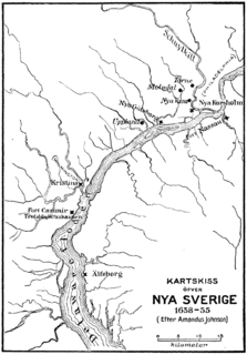
Fort Nya Elfsborg was a fortification and settlement established as a part of New Sweden. Built in 1643 and named after the Älvsborg Fortress off Gothenburg, Fort Nya Elfsborg was located on the New Jersey side of the Delaware River, between present day Salem and Alloway Creek.

Alloway Creek is a 23.2-mile-long (37.3 km) tributary of the Delaware River in Salem County, New Jersey in the United States. The name is a derivative of Allowas, an Indian chief. It has also been known by other names: Aloes River, Aloes Creek, Cotton River, Korten River, Short River, Monmouth River, Munmouth River, and Roiter's River.
Back Creek is an estuary of Delaware Bay in Cumberland County, New Jersey in the United States.
Nantuxent Creek is a 5.5-mile-long (8.9 km) estuary of Delaware Bay in Cumberland County, New Jersey in the United States.
Cedar Creek is a 10.5-mile-long (16.9 km) stream and estuary of Delaware Bay in Cumberland County, New Jersey in the United States.
Oldmans Creek is a 22.1-mile-long (35.6 km) tributary of the Delaware River in southwestern New Jersey in the United States.
West Creek is a 12.3-mile-long (19.8 km) tributary of Delaware Bay in Cape May County, New Jersey in the United States.
The Delaware River Region refers to an area in western New Jersey (USA) along the Delaware River border with Pennsylvania. It encompasses Burlington County, Camden County, Gloucester County, Mercer County, and Salem County. The area is primarily part of Greater Philadelphia with the exception of Mercer County, which is part of the New York City Metropolitan Area. It is one of six officially recognized tourism regions by the New Jersey Department of Tourism, the others being the Greater Atlantic City Region, the Skylands Region, the Southern Shore Region, the Shore Region and the Gateway Region.

The Southern Shore Region is located in the southeastern part of State of New Jersey in the United States of America. It is one of six tourism regions established by the New Jersey State Department of Tourism, the others being the Gateway Region, Greater Atlantic City, the Delaware River Region, the Shore Region and the Skylands Region. The area includes Cape May County and Cumberland County. The coast is along the Atlantic Ocean and Delaware Bay, while the inland areas are part of the New Jersey Pine Barrens.

Centerton is an unincorporated community located within Pittsgrove Township, in Salem County, New Jersey, United States. County Route 540 is a major road that travels through Centerton and passes Centerton Pond. Route 55 provides access to Centerton, via exit 45. Centerton is approximately 5 miles (8.0 km) west of Vineland in Cumberland County.
Artificial Island, is an American island located along the eastern shore of the Delaware River, mostly in southwestern New Jersey with a tiny portion inside Delaware's boundaries. It is part of both Lower Alloways Creek Township, Salem County, New Jersey and New Castle County, Delaware. The island is separated from mainland New Jersey by Alloway Creek and Hope Creek. It is called "artificial" since portions of the island are composed of land reclaimed from Delaware Bay.
Money Island is the smallest and most remote of five rural communities that make up Downe Township in Cumberland County in the U.S. state of New Jersey. The community is located on the shore of the Delaware Bay on the southern side of Nantuxent Creek. Its location may be described as the southwest corner of New Jersey.
Othello is an unincorporated community located within Greenwich Township, Cumberland County, New Jersey, United States. It is part of the Greenwich Historic District, which has been on the National Register of Historic Places since 1972.
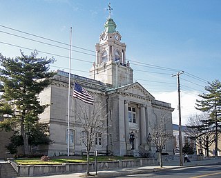
The Cumberland County Courthouse is the historic traditional courthouse for Cumberland County, New Jersey located in the county seat, Bridgeton. It in the 15th vicinage.


