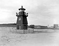
List of lighthouses in South Carolina

Last updated

This is a list of lighthouses in South Carolina .

NameImageLocationCoordinatesYear first litAutomatedYear deactivatedCurrent LensFocal Height
Bloody Point Range Front Light N/A Daufuskie Island N/A1883Never1922
(Preserved)
NoneUnknown
Bloody Point Range Rear Light N/A Daufuskie Island N/A1883 (First)
1899 (Last)
Never1922
(Removed)
None81 ft (25 m)
(Original rear range)
Bulls Bay Light N/A Charleston County N/A1852 (First)
1900 (Last)
Never1913
(Destroyed)
None44 ft (13 m)
(First lighthouse)
Cape Romain Light (Old) Cape Romain 1827 Lighthouse.jpg Cape Romain 33°01′06.6″N79°22′26.6″W / 33.018500°N 79.374056°W / 33.018500; -79.374056 1827Never1858None88 ft (27 m)
Cape Romain Light (New) Cape Romain 1857 Lighthouse.jpg Cape Romain 33°01′08″N79°22′25″W / 33.01889°N 79.37361°W / 33.01889; -79.37361 185819371947None161 ft (49 m)
Castle Pinckney Light Castle Pinckney - showing early light beacon.jpg Charleston County 32°46′25.1″N79°54′39.6″W / 32.773639°N 79.911000°W / 32.773639; -79.911000 1855 (First)
1890 (Last)
Never1917
(Destroyed by 1938)
None50 ft (15 m)
Charleston Light Charleston Light 1962.jpg Sullivan's Island 32°45′28.5″N79°50′35.7″W / 32.757917°N 79.843250°W / 32.757917; -79.843250 19621975Active DCB-24 163 ft (50 m)
Combahee Bank Light N/A Saint Helena Sound 32°28′N80°26′W / 32.467°N 80.433°W / 32.467; -80.433 1868Never1876
(Removed in 1925)
NoneUnknown
Fort Ripley Shoal Light Charleston 32°45′58″N79°54′07″W / 32.766°N 79.902°W / 32.766; -79.902
(Estimated)
1878Never1932
(Dismantled)
NoneUnknown
Fort Sumter Range Front Light Fort Sumter Lighthouse (Charleston County, South Carolina).jpg Charleston 32°45′8″N79°52′29″W / 32.75222°N 79.87472°W / 32.75222; -79.87472 1855 (First)
1893 (Last)
Never1950sNoneUnknown
Fort Sumter Range Rear Light St. Philip's Episcopal Church (Charleston, South Carolina).jpg Charleston 32°45′8″N79°52′29″W / 32.75222°N 79.87472°W / 32.75222; -79.87472 1855 (First)
1893 (Last)
Never1915None140 ft (43 m)
Georgetown Light Georgetown Light.jpg Winyah Bay 33°13′21.47″N79°11′6.18″W / 33.2226306°N 79.1850500°W / 33.2226306; -79.1850500 1801 (First)
1867 (Current)
1986Active VRB-25 85 ft (26 m)
Governor's Light A N/A Little River N/A1985 [1]
(Private)
AlwaysActiveUnknown60 ft (18 m) [1]
Haig Point Front Range Light Haig Point Front Range Light, Daufuskie Island (Beaufort County, South Carolina).jpg Daufuskie Island N/A1873 [2] NeverDisputed B
(Removed)
None17 ft (5.2 m) [2]
Haig Point Rear Range Light Haig Point Rear Range Light, Daufuskie Island (Beaufort County, South Carolina).jpg Daufuskie Island N/A18731987
(Relit)
Active
(Inactive: ????-1987 B )
Acrylic70 ft (21 m)
Harbour Town Light Harbour Town July 2007.jpg Hilton Head Island 32°08′19″N80°48′46″W / 32.13861°N 80.81278°W / 32.13861; -80.81278 1970AlwaysActiveUnknown90 ft (27 m)
Hilton Head Range Front Light N/A Hilton Head Island N/A1881Never1932
(Destroyed)
None35 ft (11 m)
Hilton Head Range Rear Light Rear Lighthouse of HH Range Light Station.jpg Hilton Head Island 32°9′51″N80°44′24″W / 32.16417°N 80.74000°W / 32.16417; -80.74000 Coordinates: 32°9′51″N80°44′24″W / 32.16417°N 80.74000°W / 32.16417; -80.74000 1880Never1932None92 ft (28 m)
Hunting Island Light Hunting Island Light.jpg Beaufort
(Hunting Island State Park)
32°22′32″N80°26′15″W / 32.37556°N 80.43750°W / 32.37556; -80.43750 1859 (First)
1875 (Current)
1995
(Relit)
Active
(Inactive: 1933-1995
Unknown132 ft (40 m)
Morris Island Range Front Light C N/A Morris Island N/A1871 [3] NeverUnknown D
(Removed)
NoneUnknown
Morris Island Range Rear Light C N/A Morris Island N/A1871 [3] NeverUnknown D
(Removed)
NoneUnknown
Morris Island Light Morris Island Light, April 2014.jpg Morris Island 32°41′43″N79°53′1″W / 32.69528°N 79.88361°W / 32.69528; -79.88361 1767 [3] (First)
1876 [3] (Current)
1938 [3] 1962 [3] NoneUnknown
Parris Island Range Front Light N/A Parris Island N/A1881Never1923NoneUnknown
Parris Island Range Rear Light N/A Parris Island 32°18′46″N80°40′39″W / 32.31278°N 80.67750°W / 32.31278; -80.67750 1881Never1923None120 ft (37 m)
Sullivan's Island Range Front Light Sullivans Island South Range Front Light (Charleston County, South Carolina).jpg Sullivan's Island N/A1848 (First)
1872 (Last)
NeverUnknown
(Removed)
NoneUnknown
Sullivan's Island Range Rear Light N/A Sullivan's Island N/A1848 (First)
1872 (Last)
NeverUnknown
(Removed)
None120 ft (37 m)

Notes

A. ^ This lighthouse was built in honor of South Carolina's governors. It is privately maintained and an unofficial aid to navigation.
B. ^ The deactivation date for the Haig Point Range Lights is disputed among sources. Click on the article for more information.
C. ^ Not much is known about this set of range lights. The two structures were built in 1871 after the second Morris Island lighthouse was destroyed in the civil war, as navigation was needed in the area.
D. ^ Listed on the light list as late as 1898. [1]

Related Research Articles

Sand Island Light (Alabama) Lighthouse

Sand Island Light, also known as Sand Island Lighthouse, is a decommissioned lighthouse located at the southernmost point of the state of Alabama, United States, near Dauphin Island, at the mouth of Mobile Bay, Alabama. It is located roughly 3 miles offshore from the primary Mobile Bay entrance, bounded on the east by Mobile Point and on the west by Dauphin Island. The lighthouse is 132 feet (40 m) high.

Morris Island Light Lighthouse in South Carolina, US

Morris Island Light is a lighthouse on Morris Island in South Carolina. The light stands on the southern side of the entrance to Charleston Harbor, north of the City of Folly Beach. At 161 ft, it is the tallest lighthouse in South Carolina. The lighthouse was named to the National Register of Historic Places in 1982.

Haig Point Range Lights Lighthouses in South Carolina, US

The Haig Point Range Lights were range lights on Calibogue Sound at the northeastern end of Daufuskie Island in Beaufort County, South Carolina. The Haig Point Range Lights were built in 1873 and were maintained as an official aid to navigation until about 1924. The Rear Range Light house has been restored. It is a guest house for the Haig Point Club and serves as a private aid to navigation.

The Bloody Point Range Lights, which is known as the Bloody Point Lighthouse, were range lights on the southern end of Daufuskie Island in Beaufort County, South Carolina. The Bloody Point Range Lights were built in 1883. Due to erosion, the front light was moved to the location of the former rear light and became the rear light. The lights were maintained as an official aid to navigation until 1922. The original Front Range Light house is currently a private home.

Tinicum Island Rear Range Light Lighthouse

The Tinicum Island Rear Range Light is a lighthouse located in the Billingsport section of Paulsboro, Gloucester County, New Jersey, United States, the rear of a pair of range lights marking a section of the channel in the Delaware River south of Philadelphia, Pennsylvania. The lighthouse, surrounded by ball fields next to the new marine terminal for the Port of Paulsboro, is still active for navigation on the Delaware River. It works in conjunction with the Tinicum Front Range Light, known as the Billingsport Front Light, situated on the banks of the Delaware River at the front of Fort Billings Park next to the Paulsboro Refinery.

The Miminegash Range Lights were a set of range lights on Prince Edward Island, Canada. They were built in 1886, and deactivated in 1972; only the rear tower has survived.

Northport Range Lights Lighthouse

The Northport Range Lights were a set of range lights on Prince Edward Island, Canada. They were built in 1885, and the rear light was deactivated around 1970; the front light is still active as the rear light of the new range.

The Malpeque Harbour Approach Range Lights are a set of range lights on Prince Edward Island, Canada. The current rear tower was built in 1961.

Malpeque Outer Range Lights Lighthouse

The Malpeque Outer Range Lights are a set of range lights on Prince Edward Island, Canada. They were built in 1922, and are still active.

Murray Harbour Range Lights Lighthouse

The Murray Harbour Range Lights are a set of range lights near Murray Harbour, Prince Edward Island, Canada. They were built in 1879, and are still active.

Wood Islands Lighthouse Lighthouse

The Wood Islands Lighthouse is a historic lighthouse built by Joseph Tomlinson III situated on the southeastern shore of Prince Edward Island, located in the community of Wood Islands. The lighthouse is a well-preserved three storey tower with an adjoining 1+12-storey keeper's residence. The white shingled tower is topped by a red iron lantern, which is enclosed by a white railing on the observation deck. The red roof of the dwelling provides a striking contrast to the white shingled exterior of the dwelling.

Haszard Point Range Front Lighthouse

The Haszard Point Range Front is one of two range lights, the front light and the rear light, on Prince Edward Island, Canada. They were built in 1889, and are still active.

The Leards Range Lights are a set of two range lights on Prince Edward Island, Canada. They were built in 1879, and are still active.

Summerside Outer Range Lights Lighthouse

The Summerside Outer Range Lights are a set of range lights near Summerside, Prince Edward Island, Canada. They were built in 1991, and are still active.

Balache Point Lighthouse Lighthouse in Nova Scotia, Canada

Balache Point Lighthouse also known as Balache Point Range Rear Lighthouse is an active Canadian lighthouse located next to the Canso Canal, near Port Hastings, Inverness County, Nova Scotia. The salt shaker style light, which sits on a small hillock on the Cape Breton side of the canal, is the second lighthouse to be built on the site.

Eeragh Lighthouse Lighthouse

Eeragh Lighthouse is an active lighthouse located on Rock Island, one of the Brannock Islands, part of the Aran Islands archipelago in County Galway, Ireland. It marks the north-western entrance to Galway Bay and the port of Galway known as the North Sound. Due to its location it is also known as the Aran North Lighthouse. The lighthouse on Inisheer at the south-eastern end of the islands was also constructed at the same time. Eeragh and Inisheer both became operational in 1857.

References

  1. 1 2 3 Rowlett, Russ. "Lighthouses of the United States: South Carolina". The Lighthouse Directory. University of North Carolina at Chapel Hill . Retrieved October 15, 2017.
  2. 1 2 "Name: Haig Point Front Range Light". Lighthouse Digest . Retrieved October 15, 2017.
  3. 1 2 3 4 5 6 "Morris Island Lighthouse". Lighthouse Friends. Retrieved October 15, 2017.