Georgetown Light

Last updated
Georgetown Light
Georgetown Light.jpg
Georgetown Light
Location Winyah Bay, South Carolina
Coordinates 33°13′21.47″N79°11′6.18″W / 33.2226306°N 79.1850500°W / 33.2226306; -79.1850500
Tower
Constructed1801
FoundationRubblestone caisson
ConstructionBrick
Automated1986
Height87 feet (27 m)
ShapeConical (nb Light List says "cylindrical")
MarkingsWhite with black lantern
HeritageNational Register of Historic Places listed place  OOjs UI icon edit-ltr-progressive.svg
Light
First lit1812, rebuilt 1867
Focal height85 feet (26 m)
Lens4th order Fresnel (1855), VRB-25 (current)
Range15 nautical miles (28 km; 17 mi)
Characteristic Fl W (2), 15 sec
Georgetown Lighthouse
Nearest city Georgetown, South Carolina
Area4 acres (1.6 ha)
Built1801 [ sic ], actually 1812
NRHP reference No. 74001857 [1]
Added to NRHPDecember 30, 1974

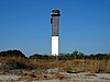
Georgetown Light is an active light on North Island at the entrance to Winyah Bay southeast of Georgetown, South Carolina. [2] [3] [4] The light is maintained by the U.S. Coast Guard, and the lighthouse is now under the control of State of South Carolina as part of the Tom Yawkey Wildlife Center Heritage Preserve. The lighthouse is on the National Register of Historic Places.

The original lighthouse was a cypress tower. It was destroyed by a storm in 1806. In 1812, a 72 feet (22 m) brick tower was built. A fourth-order Fresnel lens was installed in 1857. It was rebuilt and raised to 87 feet (27 m) in 1867 after suffering damage during the Civil War. [3]

The light was automated in 1986. The focal plane is 85 feet (26 m) above mean high water. [2]

Related Research Articles

<span class="mw-page-title-main">Cape Hatteras Lighthouse</span> Lighthouse in North Carolina, United States

Cape Hatteras Light is a lighthouse located on Hatteras Island in the Outer Banks in the town of Buxton, North Carolina and is part of the Cape Hatteras National Seashore. The lighthouse's semi-unique pattern makes it easy to recognize and famous. It is often ranked high on lists of most beautiful, and famous lighthouses in the US.

<span class="mw-page-title-main">Block Island Southeast Light</span> Lighthouse in Rhode Island, United States

Block Island Southeast Light is a lighthouse located on Mohegan Bluffs at the southeastern corner of Block Island, Rhode Island. It was designated a U.S. National Historic Landmark in 1997 as one of the most architecturally sophisticated lighthouses built in the United States in the 19th century.

<span class="mw-page-title-main">Barnegat Lighthouse</span> Lighthouse in New Jersey, United States

Barnegat Lighthouse or Barnegat Light, is a historic lighthouse located in Barnegat Lighthouse State Park on the northern tip of Long Beach Island, in the borough of Barnegat Light, Ocean County, New Jersey, United States, on the south side of Barnegat Inlet.

<span class="mw-page-title-main">Matinicus Rock Light</span> Lighthouse in Maine, US

Matinicus Rock Light is a lighthouse on Matinicus Rock, a windswept rock 25 miles (40 km) off the coast of Maine. It is one of eleven seacoast lights off the coast of Maine. First established in 1827, the present surviving structures date to 1857. The lighthouse was added to the National Register of Historic Places as Matinicus Rock Light Station on March 14, 1988.

<span class="mw-page-title-main">Fowey Rocks Light</span> Lighthouse on Key Biscayne, Florida, United States

Fowey Rocks Light is located seven miles southeast of Cape Florida on Key Biscayne. The lighthouse was completed in 1878, replacing the Cape Florida Light. It was automated on May 7, 1975, and as of 2021 is still in operation. The structure is cast iron, with a screw-pile foundation, a platform and a skeletal tower. The light is 110 feet above the water. The tower framework is painted brown, while the dwelling and enclosed circular stair to the lantern is painted white. The original lens was a first-order drum Fresnel lens which stood about 12 feet (4 m) high and weighed about a ton (tonne). The light has a nominal range of 15 miles in the white sectors, and 10 miles in the red sectors.

<span class="mw-page-title-main">Amelia Island Light</span> Lighthouse in Florida, United States

The Amelia Island Light is the oldest existing lighthouse in the state of Florida in the United States. It is located near the northern end of Amelia Island in the northeastern part of the state. Its light marks St. Marys Entrance, the inlet leading to St. Marys River, the Cumberland Sound and the harbor of Fernandina Beach, Florida along the Amelia River. The white light flashes every ten seconds which turns red from 344° to 360° when covering the shoal water in the vicinity of Nassau Sound.

<span class="mw-page-title-main">Ponce de Leon Inlet Light</span> Lighthouse in Florida, US

The Ponce de Leon Inlet Light is a lighthouse and museum located at Ponce de León Inlet in Central Florida. At 175 feet (53 m) in height, it is the tallest lighthouse in the state and one of the tallest in the United States. It is located between St. Augustine Light and Cape Canaveral Light. Restored by the Ponce de Leon Inlet Lighthouse Preservation Association, the lighthouse became a National Historic Landmark in 1998.

<span class="mw-page-title-main">Goat Island Light</span> Lighthouse in Maine, US

Goat Island Light is a lighthouse located off Cape Porpoise near Kennebunkport in southern Maine. Goat Island Light was established in 1835 to guard the entrance to Cape Porpoise Harbor. The original station was upgraded in 1859 to the current brick tower with a fifth order Fresnel lens. Keeper's quarters were added to the island in 1860. The light station was automated by the United States Coast Guard in 1990 and is currently active. The keepers dwellings and tower are leased to the Kennebunkport Conservation Trust. Goat Island Light can be seen from shore in Cape Porpoise Harbor just off State Route 9 north of Kennebunkport or is viewable by boat. The island is currently closed to the public except by special arrangement.

<span class="mw-page-title-main">Horton Point Light</span> Lighthouse

Horton Point Light is a lighthouse on the north side of Eastern Long Island, New York in the hamlet of Southold. The lighthouse and the grounds surrounding it are under the supervision of the Town of Southold Park District.

<span class="mw-page-title-main">Cape Ann Light Station</span>

The Cape Ann Light Station on Thacher Island, off Cape Ann in Rockport, Massachusetts, is nationally significant as the last light station to be established under colonial rule and the first station in the United States to mark a navigational hazard rather than a harbor entrance. The current pair of lighthouses were built in 1861. They were both equipped with first order Fresnel lenses, which stood approximately 10 feet (3.0 m) high and weighed several tons (tonnes).

<span class="mw-page-title-main">Plymouth Light</span> Lighthouse

Plymouth Light, also known as Gurnet Light, is a historic lighthouse located on Gurnet Point at the entrance to Plymouth Bay in the town of Plymouth, Massachusetts. The light is accessible only by passing through the town of Duxbury, which lies to the north. The tower is located inside the earthworks of Fort Andrew, which existed in the Civil War, War of 1812, and Revolutionary War.

<span class="mw-page-title-main">Tarpaulin Cove Light</span> Lighthouse

The Tarpaulin Cove Light is a historic lighthouse on Naushon Island, one of the Elizabeth Islands of southern Massachusetts. It is located in the town of Gosnold, Massachusetts. Built on the site of a light station first established privately in the 18th century, the current tower dates from 1891. A keeper's house built at the same time has not survived. The light is 78 feet (24 m) above Mean High Water, and its white light is visible for 9 nautical miles.

<span class="mw-page-title-main">Bird Island Light</span> Lighthouse

Bird Island Light is a historic lighthouse at the entrance to Sippican Harbor in Marion, Massachusetts. Built in 1819, its tower is a well-preserved example of an early 19th-century masonry lighthouse. The tower and the island on which it stands were added to the National Register of Historic Places as Bird Island Light on September 28, 1987.

<span class="mw-page-title-main">Annisquam Harbor Light</span> Lighthouse

Annisquam Harbor Light Station is a historic lighthouse on Wigwam Point in the Annisquam neighborhood of Gloucester, Massachusetts. It can be viewed from nearby Wingaersheek Beach, Gloucester. It lies on the Annisquam River and is one of the four oldest lighthouses to surround the Gloucester peninsula as well as; Eastern Point Light, Ten Pound Island Light, and Thacher Island Light.

<span class="mw-page-title-main">Ten Pound Island Light</span> Lighthouse

The Ten Pound Island Light is a historic lighthouse in Gloucester Harbor in Gloucester, Massachusetts. It is located on Ten Pound Island, near the eastern end of the harbor. The tower, built in 1881, is a conical cast iron structure 30 feet (9.1 m) tall, replacing a stone tower first built on the site in 1821. The main body is painted white, and the top is painted black.

<span class="mw-page-title-main">Owls Head Light</span> Lighthouse in Maine, US

The Owls Head Light is an active aid to navigation located at the entrance of Rockland Harbor on western Penobscot Bay in the town of Owls Head, Knox County, Maine. The lighthouse is owned by the U.S. Coast Guard and licensed to the American Lighthouse Foundation. It is the centerpiece of 13-acre (5.3 ha) Owls Head State Park and was added to the National Register of Historic Places as Owls Head Light Station in 1978.

<span class="mw-page-title-main">Dice Head Light</span> Lighthouse in Maine, US

Dice Head Light is a lighthouse in the town of Castine, Maine. First established in 1829, the light was deactivated in 1937 and replaced by a skeleton tower 475 feet (145 m) to the south. When that structure was destroyed by a storm in 2007, however, the old light was reactivated in 2008.

<span class="mw-page-title-main">Egg Rock Light (Maine)</span> Lighthouse in Maine, US

Egg Rock Light is a lighthouse on Frenchman Bay, Maine. Built in 1875, it is one of coastal Maine's architecturally unique lighthouses, with a square tower projecting through the square keeper's house. Located on Egg Rock, midway between Mount Desert Island and the Schoodic Peninsula, it is an active aid to navigation, flashing red every 40 seconds. The light was listed on the National Register of Historic Places as Egg Rock Light Station in 1988.

<span class="mw-page-title-main">Libby Island Light</span> Lighthouse in Maine, United States

Libby Island Light is a lighthouse on Libby Island, marking the mouth of Machias Bay, in Machiasport, Maine. The light station was established in 1817 and is an active aid to navigation; the present granite tower was built in 1823 and improved in 1848. Libby Island Light was listed on the National Register of Historic Places as Libby Island Light Station on June 18, 1976.

<span class="mw-page-title-main">Perkins Island Light</span> Lighthouse in Maine, US

Perkins Island Light is a lighthouse on the Kennebec River in Maine. It was established in 1898, as part of a major upgrade of the river's lights — the Doubling Point Light and the separate Range Lights on the point, Perkins Island Light, and Squirrel Point Light were all built at the same time. It was listed on the National Register of Historic Places as Perkins Island Light Station in 1988.

References

  1. "National Register Information System". National Register of Historic Places . National Park Service. July 9, 2010.
  2. 1 2 Light List, Volume III, Atlantic Coast, Little River, South Carolina to Econfina River, Florida (PDF). Light List. United States Coast Guard. 2012. p. 2.
  3. 1 2 "Historic Light Station Information and Photography: South Carolina". United States Coast Guard Historian's Office. Archived from the original on 2017-05-01.
  4. Rowlett, Russ. "Lighthouses of the United States: South Carolina". The Lighthouse Directory. University of North Carolina at Chapel Hill.