Bloody Point Range Lights

Last updated

Bloody Point Range Lights
Location South Carolina, US
Coordinates 32°05′49.7″N80°52′23.5″W / 32.097139°N 80.873194°W / 32.097139; -80.873194 [ clarification needed ]
Tower
Constructed1883
ConstructionWood
Height27 feet (8.2 m) (Original Front)
91 feet (28 m) (Original Rear)
ShapeDormer window on roof of house
HeritageNRHP contributing property  OOjs UI icon edit-ltr-progressive.svg
Light
First lit1883
Deactivated1922
Focal height81 feet (25 m) (Original Rear)
LensRed steamer lens (original front and rear), decorative (current)
Bloody Point Lighthouse
Part of Daufuskie Island Historic District (ID82003831)
Added to NRHPJune 2, 1982 [1]

The Bloody Point Range Lights, which is known as the Bloody Point Lighthouse, were range lights on the southern end of Daufuskie Island in Beaufort County, South Carolina. The Bloody Point Range Lights were built in 1883. Due to erosion, the front light was moved to the location of the former rear light and became the rear light. The lights were maintained as an official aid to navigation until 1922. The original Front Range Light house is currently a private home. [2] [3]

Contents

Bloody Point is the southern end of Daufuskie Island. It was given this name because of the blood shed during the Yamasee War of 1715. [4]

Original range lights

In 1871, the U.S. Congress authorized two sets of range lights on Daufuskie Island. The other range lights were the Haig Point Range Lights on the northern end of the island. In 1882, 6.72 acres (2.72 ha) was purchased for the Bloody Point lights. [2] [3]

The Front Range Light was a red, kerosene lamp placed in a gable-fronted dormer window of the lightkeeper's house. This house, which was built by James C. LaCoste, was located near the beach on 1.72 acres (7,000 m2). The light was at a height of 27 feet (8.2 m). [2] [5]

The Rear Light was a 91-foot (28 m) tall triangular, iron skeletal tower, manufactured by the Cooper Manufacturing of Mount Vernon, Ohio. John Michael Doyle, who was an employee of the manufacturer, supervised the erection of the tower on a concrete foundation on 5 acres (2.0 ha) plot about 4,350 feet (1,330 m) inland of the front light. Doyle became the first light keeper. A brick lamp house, which was also called a wick house, was built at the base of the tower to house the lamp during the day. At night, the red steamer lamp with parabolic reflector was raised on rails to a height of 81 feet (25 m). The Bloody Point Range Lights were lit on 1883. [2] A nearby brick oil house for storage of kerosene was also built. [6]

Later configuration

Due to erosion, the front light was moved in 1899 to a location near the rear light, which was dismantled. In its new position, it became the rear light. A 45 feet (14 m) tall wooden house on metal legs was placed on leased land near the shore. The metal legs rested on metal disks that could be slid across the beach as the channel shifted. This light was moved several times over the next twenty years. The range lights were deactivated in 1922. [2] [3] [7] [8]

In 1925, the lightkeeper house was sold. [9] The front range light had already been lost due to erosion. The house was sold at auction and then sold to its last light keeper, Gus Ohman. In 1926, he sold it to a former assistant light keeper, Arthur A. "Papy" Burn, Jr., who lived there for about 40 years. In 1953, Papy Burn started making wine using blackberries, elderberries, scuppernongs, and other fruit in the lamp house [3] [10] and/or the oil house. [2] [11] Although wine making was a small operation, he called the building the Silver Dew Winery. Two small brick buildings with the sign for the Silver Dew Winery were described by Pat Conroy in his autobiographical book the Water is Wide . [12] [13]

In 1981, the house was renovated as a private home. The property was seized for back taxes owed and sold. It was purchased in an auction at the Beaufort County Courthouse in 1983. After serving as a temporary pro shop for a golf course, it is now a private residence. [2] [10]

The former Front Range House is a contributing property of the National Register of Historic Places' Daufuskie Island Historic District. The nomination form and an additional pictures are available from the South Carolina Department of Archives and History. [14] [15]

Related Research Articles

<span class="mw-page-title-main">Daufuskie Island</span> Census-designated place in South Carolina, United States

Daufuskie Island, located between Hilton Head Island and Savannah, is the southernmost inhabited sea island in South Carolina. It is 5 miles (8 km) long by almost 2.5 miles (4.0 km) wide – approximate surface area of 8 square miles (21 km2). With over 3 miles (5 km) of beachfront, Daufuskie is surrounded by the waters of Calibogue Sound, the Intracoastal Waterway and the Atlantic Ocean. It was listed as a census-designated place in the 2020 census with a population of 557.

<span class="mw-page-title-main">Hunting Island Lighthouse</span> Lighthouse in South Carolina, US

The Hunting Island Light is located in Hunting Island State Park on Hunting Island near Beaufort, South Carolina. Although no longer used as a functioning lighthouse, the tower is a fixture at the state park and is open to visitors. It was named to the National Register of Historic Places in 1970.

<span class="mw-page-title-main">Gasparilla Island Lights</span> Lighthouses on Gasparilla Island, Boca Grande, Florida, U.S.

The Gasparilla Island Lights are on Gasparilla Island in Boca Grande, Florida. The Port Boca Grande Lighthouse is on the southern tip of Gasparilla Island, and marked the Boca Grande Pass entrance to Charlotte Harbor.

<span class="mw-page-title-main">Liston Range Rear Light</span> Lighthouse in Delaware, United States

Liston Range Rear Lighthouse is a lighthouse in Delaware, United States, on the Delaware River. The 120 feet (37 m) wrought iron tower was made by the Kellogg Bridge Company of Buffalo, New York. The light was built several miles to the east of its present location in 1876–1877, and was moved in 1906. The light was listed on the National Register of Historic Places in 1978. It is the tallest lighthouse in Delaware.

<span class="mw-page-title-main">St. Simons Island Light</span> Lighthouse

The St. Simons Island Light is a lighthouse on the southern tip of St. Simons Island, Georgia, United States. It guides ships into St. Simons Sound and warns of the many sandbars in the area.

<span class="mw-page-title-main">St. Clair Flats Front and Rear Range Light</span> Lighthouses in Michigan, United States

St. Clair Flats Front and Rear Range Light are two lighthouse structures situated off the southeastern tip of Harsens Island at Lake St. Clair.

<span class="mw-page-title-main">Copper Harbor Light</span> Lighthouse in Michigan, United States

The Copper Harbor Light is a lighthouse located in the harbor of Copper Harbor, Michigan USA on the Keweenaw Peninsula of Upper Michigan inside Fort Wilkins Historic State Park. It is a Michigan State Historic Site and listed on the National Register of Historic Places.

<span class="mw-page-title-main">Hilton Head Range Rear Light</span> Lighthouse in South Carolina, US

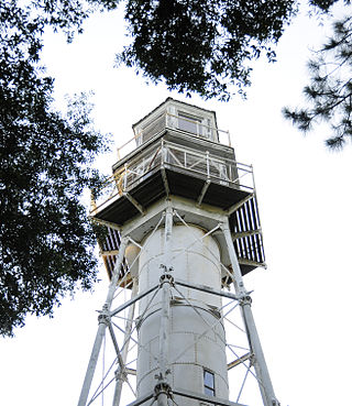
The Rear Lighthouse of Hilton Head Range Light Station, which is also called Leamington Lighthouse is an inactive light station on Hilton Head Island in Beaufort County, South Carolina. In 1983, it was named to the National Register of Historic Places.

<span class="mw-page-title-main">Haig Point Range Lights</span> Lighthouses in South Carolina, US

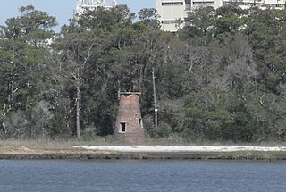
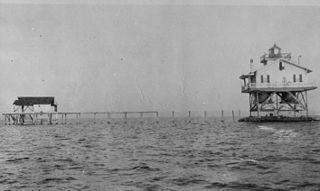
The Haig Point Range Lights were range lights on Calibogue Sound at the northeastern end of Daufuskie Island in Beaufort County, South Carolina. The Haig Point Range Lights were built in 1873 and were maintained as an official aid to navigation until about 1924. The Rear Range Light house has been restored. It is a guest house for the Haig Point Club and serves as a private aid to navigation.

<span class="mw-page-title-main">Cove Island Light</span> Lighthouse

The Cove Island Light, at Gig Point on the island, is located in Fathom Five National Marine Park, but is not part of the Park. It is situated on the Bruce Peninsula, Ontario Canada. It has been a navigational aid in the narrow channel between Lake Huron and Georgian Bay since 30 October 1858. It was the first of six stone Imperial Towers to be completed; all were illuminated by 1859. Most other lighthouses of the era were built of brick, wood, iron or concrete.

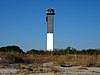
The Parris Island Range Lights were range lights on the southern end of Parris Island in Beaufort County, South Carolina. The Parris Range Lights were first lit in 1881. They were deactivated in 1912. Only the lens house for the Rear Light remains, which is the oldest building at Parris Island.

<span class="mw-page-title-main">Sullivan's Island Range Lights</span> Lighthouses in South Carolina, US

The Sullivan's Island Range Lights were range lights on the southern end of Sullivan's Island in Charleston County, South Carolina. The light station was first established in 1848 and was destroyed in 1861 during the Civil War. It was rebuilt after the war and the lights were in existence at least as late as 1901. Neither of the range lights still remains today.

<span class="mw-page-title-main">Harbour Town Light</span> Lighthouse in South Carolina, United States

The Harbour Town Lighthouse is a lighthouse at the Harbour Town Marina at Hilton Head Island, South Carolina. It was privately built and is a private aid to navigation. Although initially ridiculed by local residents during the planning and construction phases, the lighthouse became instantly popular and is today the most recognizable symbol of Hilton Head Island and Sea Pines Resort. The annually televised The Heritage golf tournament has helped increase the lighthouse's fame to millions of golf fans worldwide, and the 18th hole at the Harbour Town Golf Links has become one of the most popular and recognizable finishing holes in golf.

<span class="mw-page-title-main">Price Creek Light</span> Lighthouse in North Carolina, US

The Price Creek Lighthouse, also known as the Price's Creek Lighthouse, is a structure located near Southport, North Carolina. It was one of two range lights at Price Creek in a series of lights to guide ships from Cape Fear to Wilmington, North Carolina.

<span class="mw-page-title-main">Tinicum Island Rear Range Light</span> Lighthouse

The Tinicum Island Rear Range Light is a lighthouse located in the Billingsport section of Paulsboro in Gloucester County, New Jersey, the rear of a pair of range lights marking a section of the channel in the Delaware River south of Philadelphia.

<span class="mw-page-title-main">Cat Island Light</span> Lighthouse

The Cat Island Light was a lighthouse located on Cat Island off the coast of Mississippi. Originally built to guide shipping through the Mississippi Sound, it was discontinued as traffic moved further south.

<span class="mw-page-title-main">Wood Islands Lighthouse</span> Lighthouse

The Wood Islands Lighthouse is a historic lighthouse built by Donald MacMillan situated on the southeastern shore of Prince Edward Island, located in the community of Wood Islands. The lighthouse is a well-preserved three storey tower with an adjoining 1+12-storey keeper's residence. The white shingled tower is topped by a red iron lantern, which is enclosed by a white railing on the observation deck. The red roof of the dwelling provides a striking contrast to the white shingled exterior of the dwelling.

<span class="mw-page-title-main">Grand Marais Harbor of Refuge Inner and Outer Lights</span> Lighthouses in Michigan, United States

The Grand Marais Harbor of Refuge Inner and Outer Lights are a pair of lighthouses located on the west pier at the entry to Grand Marais Harbor of Refuge, in Grand Marais, Michigan. They were listed on the National Register of Historic Places in 2012.

Bloody Point is a residential community on the southernmost tip of Daufuskie Island, South Carolina, United States. It is bordered by the Atlantic Ocean on one side and Mungen River on the other.

<span class="mw-page-title-main">Cape Race Lighthouse</span> Lighthouse

Cape Race Lighthouse is an active lighthouse located at Cape Race on the Avalon Peninsula, Newfoundland. The light's characteristic is a single white flash every 7.5 seconds; additionally, a foghorn may sound a signal of two blasts every 60 seconds. It is located on one of Canada's busiest shipping lanes. The lighthouse is also a tourist attraction.

References

  1. "National Register Information System". National Register of Historic Places . National Park Service. April 15, 2008.
  2. 1 2 3 4 5 6 7 Burn, Billie, An Island Named Daufuskie, The Reprint Company, Inc., Spartanburg, SC, 1991, pp. 187-203, ISBN   0-87152-454-6.
  3. 1 2 3 4 Clary, Margie Willis, The Beacons of South Carolina, Sandlapper Publishing Co., Inc., Orangeburg, SC, 2005, pp. 59-67, ISBN   0-87844-176-X.
  4. Edgar, Walter, The South Carolina Encyclopedia, University of South Carolina Press, Columbia, SC, 2006, p. 247, ISBN   1-57003-598-9.
  5. "Bloody Point Lighthouse" (PDF). Beaufort County Historical Survey - 1997. Beaufort County, South Carolina. Retrieved July 16, 2008.[ dead link ]
  6. "Bloody Point Lighthouse, Oil House" (PDF). Beaufort County Historical Survey - 1997. Beaufort County, South Carolina. Retrieved July 16, 2008.[ dead link ]
  7. "Historic Light Station Information and Photography: South Carolina". United States Coast Guard Historian's Office. Archived from the original on May 1, 2017. Retrieved July 14, 2008.
  8. Roberts, Bruce, and Jones, Ray, Southern Lighthouses: Outer Banks to Cape Florida, 3rd ed., Globe Pequot Press, Guildord, CT, 2002, pp. 48-49, ISBN   0-7627-1243-0.
  9. Zepke, Terrance, Lighthouse of the Carolinas, Pineapple Press, Sarasota, FL, 2002, pp. 153-157, ISBN   1-56164-148-0.
  10. 1 2 "History of the Bloody Point Lighthouse". Low Country Joe's website. www.lowcountryjoe.com. Archived from the original on May 11, 2008. Retrieved July 17, 2008.
  11. Bansemer, Roger, Bansemer's Book of Carolina & Georgia Lighthouses, Pineapple Press, Sarasota, FL, 2000, pp. 96-97, ISBN   1-56164-194-4.
  12. "Bloody Point Front Range, SC". The Lighthouses. Lighthousefriends.com. Archived from the original on October 13, 2007. Retrieved July 18, 2008.
  13. Conroy, Pat, The Water is Wide, Houghton Mifflin Company, Boston, MA, 1972, p. 69, ISBN   0-395-13644-X.
  14. "Daufuskie Island Historic District" (PDF). National Register of Historic Places Inventory - Nomination Form. South Carolina Department of Archives and History. Retrieved July 14, 2008.
  15. "Daufuskie Island Historic District". South Carolina Department of Archives and History. Retrieved July 14, 2008.