Charles Pinckney was an American Founding Father, planter, and politician who was a signer of the United States Constitution. He was elected and served as the 37th governor of South Carolina, later serving two more non-consecutive terms. He also served as a U.S. Senator and a member of the House of Representatives. He was first cousin once removed of fellow signer Charles Cotesworth Pinckney.

The current Bodie Island Lighthouse is the third that has stood in this vicinity of Bodie Island on the Outer Banks in North Carolina and was built in 1872. It stands 156 feet (48 m) tall and is located on the Roanoke Sound side of a portion of a peninsula that is the first part of the Cape Hatteras National Seashore. The lighthouse is just south of Nags Head, a few miles before Oregon Inlet. It was renovated from August 2009 to March 2013, and was made climbable by the public. There are 214 steps that spiral to the top. The 170-foot structure is one of only a dozen remaining tall, brick tower lighthouses in the United States — and one of the few with an original first-order Fresnel lens to cast its light.

Fort Moultrie is a series of fortifications on Sullivan's Island, South Carolina, built to protect the city of Charleston, South Carolina. The first fort, formerly named Fort Sullivan, built of palmetto logs, inspired the flag and nickname of South Carolina, as "The Palmetto State". The fort was renamed for the U.S. patriot commander in the Battle of Sullivan's Island, General William Moultrie. During British occupation, in 1780–1782, the fort was known as Fort Arbuthnot.
Fort Motte was developed first as Mt. Joseph Plantation; it was commandeered in 1780 by the British and fortified as a temporary military outpost in what is now South Carolina during the American Revolutionary War. It was significant for its military use as a depot for their convoys between Camden and Charleston, which they occupied. Located along the Congaree River, it is roughly 90–95 miles from Charleston by 21st-century roadways. The British had fortified the big house and surrounds, and it became known as Fort Motte, after Rebecca Brewton Motte, who had been occupying it with her family. During the Patriot Siege of Fort Motte, the plantation mansion was set on fire. The British surrendered at this site.
Castle Pinckney was a small masonry fortification constructed by the United States government, in the harbor of Charleston, South Carolina in 1810. It was used very briefly as a prisoner-of-war camp and artillery position during the American Civil War. It was named to the National Register of Historic Places in 1970.

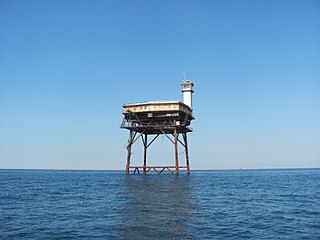
The Charlevoix South Pier Light Station is located on Lake Michigan at the entrance to Lake Charlevoix in Charlevoix County in the U.S. state of Michigan at the end of the south pier/breakwater of the channel leading to Round Lake in the city of Charlevoix.

The Cape Lookout Lighthouse is a 163-foot-high lighthouse located on the southern Outer Banks of North Carolina. It flashes every 15 seconds and is visible at least 12 miles out to sea and up to 19 miles. It is one of the very few lighthouses that operate during the day. It became fully automated in 1950. The Cape Lookout Lighthouse is the only such structure in the United States to bear the checkered daymark, intended not only for differentiation between similar light towers, but also to show direction. The center of the black diamonds points in a north-south direction, while the center of the white diamonds points east-west.

Sand Island Light, also known as Sand Island Lighthouse, is a decommissioned lighthouse located at the southernmost point of the state of Alabama, United States, near Dauphin Island, at the mouth of Mobile Bay, Alabama. It is located roughly 3 miles offshore from the primary Mobile Bay entrance, bounded on the east by Mobile Point and on the west by Dauphin Island. The lighthouse is 132 feet (40 m) high.

Morris Island Light is a lighthouse on Morris Island in South Carolina. The light stands on the southern side of the entrance to Charleston Harbor, north of the City of Folly Beach. At 161 ft, it is the tallest lighthouse in South Carolina. The lighthouse was named to the National Register of Historic Places in 1982.

Charleston, South Carolina, was a hotbed of secession at the start of the American Civil War and an important Atlantic Ocean port city for the fledgling Confederate States of America. The first shots against the Federal government were those fired there by cadets of the Citadel to stop a ship from resupplying the Federally held Fort Sumter. Three months later, the bombardment of Fort Sumter triggered a massive call for Federal troops to put down the rebellion. Although the city and its surrounding fortifications were repeatedly targeted by the Union Army and Navy, Charleston did not fall to Federal forces until the last months of the war. Charleston was devastated.
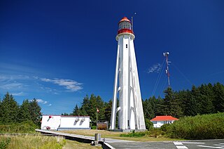
Estevan Point is a lighthouse located on the headland of the same name on the Hesquiat Peninsula on the west coast of Vancouver Island, Canada.

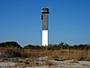
Charleston Light, also known as Sullivan's Island Lighthouse, is located on Sullivan's Island, South Carolina, which is the northern entrance to Charleston Harbor. The lighthouse was erected to replace the defunct Morris Island Light on Morris Island, which was at risk of being destroyed by erosion, but remains standing and was stabilized in 2010. Construction was started in 1960, and it was first lit on June 15, 1962.

Wolf Trap Light is a caisson lighthouse in the Virginia portion of the Chesapeake Bay, about seven and a half miles northeast of New Point Comfort Light. It is listed on the National Register of Historic Places.
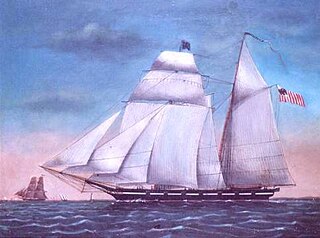
The United States Revenue Cutter Jackson was one of 13 cutters of the Morris-Taney Class to be launched. Named after Secretaries of the Treasury and Presidents of the United States, these cutters were the backbone of the Revenue Cutter Service for more than a decade. Samuel Humphreys designed these cutters for roles as diverse as fighting pirates, privateers, combating smugglers and operating with naval forces. He designed the vessels on a naval schooner concept. They had Baltimore Clipper lines. The vessels built by Webb and Allen, designed by Isaac Webb, resembled Humphreys' but had one less port.

The Floating Battery of Charleston Harbor was an ironclad vessel that was constructed by the Confederacy in early 1861, a few months before the American Civil War ignited. Apart from being a marvel to contemporary Charlestonians, it was a strategic naval artillery platform that took part in the bombardment of Fort Sumter on April 12 and April 13, 1861, making it the first floating battery to engage in hostilities during the Civil War.

The Sullivan's Island Range Lights were range lights on the southern end of Sullivan's Island in Charleston County, South Carolina. The light station was first established in 1848 and was destroyed in 1861 during the Civil War. It was rebuilt after the war and the lights were in existence at least as late as 1901. Neither of the range lights still remains today.

The Fort Sumter Range Lights are range lights to guide ships through the main channel of the Charleston Harbor, South Carolina. The original front light was built at Fort Sumter and the original rear light was in the steeple of St. Philip's Church in Charleston, South Carolina. Both lights were lit from 1893 to 1915 to make range lights. Today the Fort Sumter Range is the main approach channel to Charleston Harbor.
Diamond Shoal Light is an inactive offshore lighthouse marking Diamond Shoals off Cape Hatteras.

Ship Island Light was a lighthouse in Mississippi near Gulfport.
The following is a timeline of the history of Charleston, South Carolina, USA.