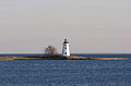
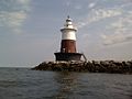
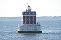
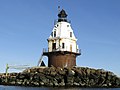
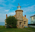
Name Location Coordinates Image Focal Built [ note 1] Automated Deactivated Status Avery Point Light Groton 41°18′55″N 72°03′49″W / 41.3153°N 72.0636°W / 41.3153; -72.0636 (Avery Point Light ) 55 ft (17 m) [ 3] 1944 [ 3] 1967–2006 [ 3] Active; private aid Black Rock Harbor Light Fayerweather Island 41°08′32″N 73°13′02″W / 41.1423°N 73.2173°W / 41.1423; -73.2173 (Black Rock Harbor Light ) 44 ft (13 m) [ 4] 1808/1823 [ 5] : 49 1932 [ 5] : 49 Relit in 2000 as non-navigational light. [ 6] Bridgeport Harbor Light Bridgeport 41°09′24″N 73°10′47″W / 41.1567°N 73.1798°W / 41.1567; -73.1798 (Bridgeport Harbor Light ) 52 ft (16 m) [ 7] 1851/1871 [ 8] 1953 Destroyed by fire in 1953 while dismantling the lighthouse; was replaced with a skeleton tower . [ 9] Falkner Island Light Guilford 41°12′44″N 72°39′13″W / 41.2121°N 72.6536°W / 41.2121; -72.6536 (Falkner Island Light ) 94 ft (29 m) [ 10] : 30 1802 [ 10] : 30 1978 [ 11] — Active Five Mile Point Light [ note 2] New Haven 41°14′56″N 72°54′14″W / 41.2490°N 72.9038°W / 41.2490; -72.9038 (Five Mile Point Light ) [ 13] 97 ft (30 m) [ 10] : 30 1805/1845 [ 10] : 30 1877 [ 10] : 30 Inactive Great Captain Island Light Greenwich 40°58′57″N 73°37′25″W / 40.9825°N 73.6235°W / 40.9825; -73.6235 (Great Captain Island Light ) 51 ft (16 m) 1830/1868 [ 10] : 30 1970 [ 10] : 30 Non-navigational light [ 14] Greens Ledge Light Norwalk 41°02′30″N 73°26′38″W / 41.0418°N 73.4438°W / 41.0418; -73.4438 (Greens Ledge Light ) 62 ft (19 m) [ 10] : 31 1902 [ 10] : 31 1972 [ 11] — Active Lynde Point Light [ note 3] Old Saybrook 41°16′17″N 72°20′35″W / 41.2715°N 72.3430°W / 41.2715; -72.3430 (Lynde Point Light ) 71 ft (22 m) [ 10] : 32 1803/1838 [ 10] : 32 1975 [ 11] — Active Morgan Point Light Noank 41°18′59″N 71°59′22″W / 41.3164°N 71.9894°W / 41.3164; -71.9894 (Morgan Point Light ) [ 15] 61 ft (19 m) [ 16] 1831/1868 [ 10] : 33 1919 [ 10] : 33 Inactive Mystic Seaport Light Mystic, Connecticut 41°12′51″N 71°34′52″W / 41.2141°N 71.5811°W / 41.2141; -71.5811 (Mystic Seaport Light ) 26 ft (7.9 m) [ 17] 1966 [ 18] — — museum replica of Brant Point Light ; not an aid to navigation New London Harbor Light New London 41°19′00″N 72°05′23″W / 41.3166°N 72.0898°W / 41.3166; -72.0898 (New London Harbor Light ) 89 ft (27 m) [ 10] : 34 1760/1801 [ 10] : 34 1912 [ 11] — Active New London Ledge Light New London 41°18′21″N 72°04′39″W / 41.3059°N 72.0774°W / 41.3059; -72.0774 (New London Ledge Light ) 58 ft (18 m) [ 10] : 34 1760/1909 [ 10] : 34 1987 [ 11] — Active Pecks Ledge Light Norwalk 41°04′39″N 73°22′11″W / 41.0774°N 73.3697°W / 41.0774; -73.3697 (Pecks Ledge Light ) 61 ft (19 m) [ 10] : 35 1906 [ 10] : 35 1933 [ 11] — Active Penfield Reef Light Fairfield 41°07′02″N 73°13′20″W / 41.1171°N 73.2221°W / 41.1171; -73.2221 (Penfield Reef Light ) 51 ft (16 m) [ 10] : 35 1874 [ 10] : 35 1971 [ 11] — Active Saybrook Breakwater Light [ note 4] Old Saybrook 41°15′48″N 72°20′34″W / 41.2632°N 72.3427°W / 41.2632; -72.3427 (Saybrook Breakwater Light ) 58 ft (18 m) [ 10] : 36 1886 [ 10] : 36 1959 [ 11] — Active Sheffield Island Light Norwalk 41°02′56″N 73°25′09″W / 41.0488°N 73.4192°W / 41.0488; -73.4192 (Sheffield Island Light ) [ 19] 51 ft (16 m) [ 20] 1828/1868 [ 20] 1902 [ 10] : 36 Inactive Southwest Ledge Light New Haven 41°14′04″N 72°54′44″W / 41.2344°N 72.9122°W / 41.2344; -72.9122 (Southwest Ledge Light ) 57 ft (17 m) [ 21] 1877 [ 10] : 37 1973 [ 11] — Active Stamford Harbor Ledge Light Stamford 41°00′49″N 73°32′34″W / 41.0136°N 73.5428°W / 41.0136; -73.5428 (Stamford Harbor Ledge Light ) 80 ft (24 m) [ 22] 1882 [ 10] : 38 1953 [ 10] : 38 Active; private aid Stonington Harbor Light Stonington 41°19′43″N 71°54′20″W / 41.3285°N 71.9055°W / 41.3285; -71.9055 (Stonington Harbor Light ) [ 23] 62 ft (19 m) [ 24] 1823/1840 [ 10] : 39 1889 [ 10] : 39 Inactive; museum [ 10] : 39 Stratford Point Light Stratford 41°09′07″N 73°06′12″W / 41.1520°N 73.1032°W / 41.1520; -73.1032 (Stratford Point Light ) 52 ft (16 m) [ 10] : 39 1822/1881 [ 10] : 39 1970 [ 11] — Active Stratford Shoal Light Long Island Sound east of Bridgeport 41°03′35″N 73°06′05″W / 41.0598°N 73.1013°W / 41.0598; -73.1013 (Stratford Shoal Light ) 60 ft (18 m) [ 10] : 40 1877 [ 10] : 40 1970 [ 11] — Active Tongue Point Light [ note 5] Bridgeport 41°10′00″N 73°10′39″W / 41.1666°N 73.1775°W / 41.1666; -73.1775 (Tongue Point Light ) 31 ft (9.4 m) [ 10] : 29 1895 [ 10] : 29 1954 [ 10] : 29 1954 [ 10] : 29 Active [ 10] : 29