This is a list of all lighthouses in the U.S. state of Louisiana.
| Name | Image | Location | Coordinates | Year first lit | Automated | Year deactivated | Current Lens | Focal Height |
|---|---|---|---|---|---|---|---|---|
| Chandeleur Island Light |  | Chandeleur Islands | 1848 (First) 1896 (Last) | Unknown | 2005 (Destroyed) | None | 102 ft (31 m) | |
| East Rigolets Light | 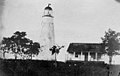 | Lake Borgne (Rigolets) | 1833 | Never | 1874 (Destroyed by 1924) | None | 60 ft (18 m) [1] | |
| Frank's Island Light | Mississippi River Delta | N/A | 1823 | Never | 1855 A (Replaced) | None | Unknown | |
| New Canal Light |  | New Orleans | 1839 (First) 1890 (Current) | 1941 | Active B (Inactive: 2005–2012) | Unknown | 49 ft (15 m) | |
| Pass A L'Outre Light |  | Mississippi River Delta | 1855 | Never | 1930 (Abandoned) | None | 77 ft (23 m) (Original height) | |
| Pass Manchac Light |  | Manchac | 1839 (First) 1857 (Last) | 1941 | 1987 (Destroyed in 2012) | None | Unknown | |
| Point Au Fer Reef Light |  | Atchafalaya Basin | 1916 (First) 1975 (Current) | Unknown | Active | Unknown | 54 ft (16 m) | |
| Port Pontchartrain Light | N/A | New Orleans | N/A | 1839 (First) 1855 (Current) | Never | 1929 | None | Unknown |
| Sabine Pass Light | 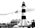 | Cameron Parish | 1857 | Never | 1952 | None | 85 ft (26 m) | |
| Ship Shoal Light |  | Last Island | 1860 | 1929 | 1965 | None | 105 ft (32 m) | |
| South Pass Range Front Light | N/A | Plaquemines Parish | N/A | 1886 (First) 1947 (Last) | Unknown | Unknown C (Destroyed) | None | Unknown |
| South Pass Light (aka: South Pass Rear Range Light) |  | Plaquemines Parish | 1832 (First) 1881 (Current) | 1971 | Active | DCB-224 | 105 ft (32 m) | |
| Southwest Pass Light | N/A | Plaquemines Parish | N/A | 1832 D (First) 2007 (Current) | 1984 | Active | Unknown | 128 ft (39 m) (Third tower) D |
| Southwest Reef Light |  | Atchafalaya Basin | 1859 | Never | 1916 | None | 49 ft (15 m) | |
| Tchefuncte River Range Front Light |  | Madisonville | 1903 (First) 1915 (Last) | Unknown | Unknown (Removed) | None | 25 ft (7.6 m) | |
| Tchefuncte River Range Rear Light |  | Madisonville | 1837 (First) 1867 (Current) | 1952 | Active | 250mm | 49 ft (15 m) | |
| Trinity Shoal Light |  | Trinity Shoal | N/A | Never built | Never | N/A | None | N/A |
| West Rigolets Light | 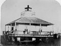 | Lake Borgne (Rigolets) | [2] | 1854 | Never | 1945 (Destroyed in 2005) | None | 29 ft (8.8 m) |