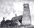
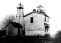
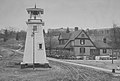
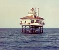
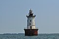
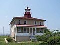
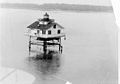
Name Image Location Coordinates Year first lit Automated Year deactivated Current Lens Focal Height Baltimore Harbor Light Chesapeake Bay 39°03′33″N 76°23′56″W / 39.05919°N 76.399°W / 39.05919; -76.399 1908 [ 3] 1923 [ 3] Active Unknown 052 52 ft (16 m) Blakistone Island Light Coltons Point (St. Clement's ) 38°12′27″N 76°44′42″W / 38.2074°N 76.7449°W / 38.2074; -76.7449 1851 1932 1956(Destroyed, rebuilt as Decorative Unknown Bloody Point Bar Light Kent Island 38°50′02″N 76°23′30″W / 38.8338°N 76.3917°W / 38.8338; -76.3917 1882 1961 Active Acrylic 054 54 ft (16 m) Bodkin Island Light Patapsco River (Mouth) 39°08′2.4″N 76°25′37.2″W / 39.134000°N 76.427000°W / 39.134000; -76.427000 1822 Never 1856(Destroyed in 1914) None Unknown Cedar Point Light Patuxent River (Mouth) 39°17′57.12″N 76°23′9.6″W / 39.2992000°N 76.386000°W / 39.2992000; -76.386000 1896 Never 1928(Dismantled in 1996) None Unknown Choptank River Light Tred Avon River (Mouth) 38°39′20″N 76°11′08″W / 38.6555°N 76.1855°W / 38.6555; -76.1855 1871 (First) (Last) (Replica) Never 1964(Dismantled) Fifth-order Fresnel (Inside replica) Unknown Clay Island Light Nanticoke River (Mouth) 38°14′02″N 75°58′12″W / 38.234°N 75.970°W / 38.234; -75.970 1832 Never 1892(Destroyed in 1894) None 036 36 ft (11 m) Cobb Point Bar Light Cobb Island 38°14′33″N 76°49′36″W / 38.2424°N 76.8266°W / 38.2424; -76.8266 1889 Never 1940(Demolished after fire) None Unknown Concord Point Light Havre de Grace 39°32′27″N 76°05′05″W / 39.5407°N 76.0848°W / 39.5407; -76.0848 1827 1920 Active(Inactive: 1975-1983) Fifth-order Fresnel 036 36 ft (11 m) Cove Point Light Solomons 38°23′11″N 76°22′54″W / 38.3863°N 76.3817°W / 38.3863; -76.3817 1828 1986 Active Unknown 038 38 ft (12 m) Craighill Channel Lower Range Edgemere 39°11′19″N 76°23′40″W / 39.1886°N 76.3945°W / 39.1886; -76.3945 1875 1964 Active Unknown 025 25 ft (7.6 m) Craighill Channel Lower Range Edgemere 39°13′45″N 76°23′39″W / 39.2291°N 76.3942°W / 39.2291; -76.3942 1875 1923 Active Unknown 105 105 ft (32 m) Craighill Channel Upper Range Edgemere 39°11′50″N 76°26′54″W / 39.1971°N 76.4482°W / 39.1971; -76.4482 1886 1914 Active Unknown 015 15 ft (4.6 m) Craighill Channel Upper Range Edgemere (Sparrows Point ) 39°12′58.32″N 76°27′45.72″W / 39.2162000°N 76.4627000°W / 39.2162000; -76.4627000 1886 1933 Active Unknown 064 64 ft (20 m) Drum Point Light Solomons (Originally at Drum Point ) 38°19′08″N 76°25′16″W / 38.319°N 76.421°W / 38.319; -76.421 (approximate original) 38°19′52″N 76°27′47″W / 38.331°N 76.463°W / 38.331; -76.463 (current) 1883 1960(Semi) 1962(Now a museum) None 025 25 ft (7.6 m) Fishing Battery Light Havre de Grace 39°29′42″N 76°04′59″W / 39.495°N 76.083°W / 39.495; -76.083 1853 1917 1921(Replaced with None Unknown Fog Point Light Smith Island 38°01′48″N 76°02′30″W / 38.0299°N 76.0417°W / 38.0299; -76.0417 1827 Never 1875(Later destroyed) None Unknown Fort Carroll Light Baltimore 39°12′52.92″N 76°31′11.64″W / 39.2147000°N 76.5199000°W / 39.2147000; -76.5199000 1854 (Former) (Current) 1923 1964(Vandalized) None 045 45 ft (14 m) Fort Washington Light Fort Washington 38°42′44.3″N 77°2′12.8″W / 38.712306°N 77.036889°W / 38.712306; -77.036889 1857 (Former) (Current) Unknown Active Unknown Unknown Great Shoals Light Wicomico River (Mouth) 38°12′51″N 75°52′46″W / 38.2143°N 75.8794°W / 38.2143; -75.8794 1882 Never 1966 None 037 37 ft (11 m) Greenbury Point Light (First ) Annapolis 38°58′30″N 76°27′18″W / 38.975°N 76.455°W / 38.975; -76.455 1848 Never 1891(Eventually collapsed [ 4] ) None 039 39 ft (12 m) [ 4] Greenbury Point Shoal Light (Second ) Annapolis 38°58′05″N 76°27′14″W / 38.968°N 76.454°W / 38.968; -76.454 1892 Never 1934(Replaced with None Unknown Hawkins Point Light Baltimore 39°12′28″N 76°31′57″W / 39.2079°N 76.5326°W / 39.2079; -76.5326 1868 Never 1924(Replaced with None 028 28 ft (8.5 m) [ 4] Holland Island Bar Light Holland Island 38°04′07″N 76°05′45″W / 38.0687°N 76.0959°W / 38.0687; -76.0959 1889 Never 1960(Demolished) None 042 42 ft (13 m) [ 4] Hooper Island Light Hooper's Island 38°15′22″N 76°15′00″W / 38.256°N 76.250°W / 38.256; -76.250 1902 1961 Active Unknown 063 63 ft (19 m) [ 4] Hooper Strait Light Saint Michaels (Originally Hooper's Island ) 38°13′36″N 76°04′32″W / 38.2267°N 76.0756°W / 38.2267; -76.0756 (Original) 38°47′15″N 76°13′09″W / 38.7875°N 76.2192°W / 38.7875; -76.2192 (Current) 1867 (Former) (Current) 1954 1966(Now a museum) None Unknown Janes Island Light Crisfield 37°57′48″N 75°55′07″W / 37.9633°N 75.9185°W / 37.9633; -75.9185 1867 (Former) (Current) Never 1935(Destroyed by ice) None 038 38 ft (12 m) [ 4] Lazaretto Point Light Baltimore 39°15′44″N 76°34′17″W / 39.2622°N 76.5715°W / 39.2622; -76.5715 1831 Never 1926(Demolished, rebuilt as None Unknown Leading Point Light Baltimore 39°12′49″N 76°33′06″W / 39.2137°N 76.5518°W / 39.2137; -76.5518 1868 Never 1924(Later demolished [ 4] ) None Unknown Love Point Light Kent Island 39°03′14″N 76°17′25″W / 39.0539°N 76.2904°W / 39.0539; -76.2904 1872 1953 1964(Demolished) None Unknown Lower Cedar Point Light Potomac River 38°20′24″N 76°59′35″W / 38.340°N 76.993°W / 38.340; -76.993 1867 (First) (Last) Never 1951(Replaced with None Unknown Maryland Point Light Potomac River 38°20′58″N 77°11′51″W / 38.3495°N 77.1975°W / 38.3495; -77.1975 1892 1954 1963(Dismantled) None Unknown Mathias Point Light Potomac River 38°24′18″N 77°02′34″W / 38.4051°N 77.0428°W / 38.4051; -77.0428 1876 1951 1961(Dismantled) None Unknown North Point Range Lights Baltimore 39°11′38″N 76°26′31″W / 39.1940°N 76.4419°W / 39.1940; -76.4419 (Front Light) 39°11′50″N 76°26′54″W / 39.1971°N 76.4482°W / 39.1971; -76.4482 (Rear Light) 1822 Never 1873(Collapsed, replaced by None 034 34 ft (10 m) [ 4] (Front) 40 ft (12 m) [ 4] (Rear) Piney Point Light Piney Point 38°08′08″N 76°31′47″W / 38.1355°N 76.5297°W / 38.1355; -76.5297 1836 Never 1964 None 034 34 ft (10 m) [ 4] Point Lookout Light Point Lookout 38°02′19″N 76°19′20″W / 38.0387°N 76.3221°W / 38.0387; -76.3221 1830 Never 1965 None 041 41 ft (12 m) [ 4] Point No Point Light Chesapeake Bay 38°07′41″N 76°17′24″W / 38.128°N 76.29°W / 38.128; -76.29 1905 1938 Active 375mm 052 52 ft (16 m) Pooles Island Light Aberdeen 39°16′44″N 76°16′12″W / 39.279°N 76.270°W / 39.279; -76.270 1825 1917 Active(Inactive: 1939-2011) Unknown 038 38 ft (12 m) Ragged Point Light Potomac River 38°09′16″N 76°36′05″W / 38.1544°N 76.6014°W / 38.1544; -76.6014 1910 Never 1962(Dismantled) None Unknown Sandy Point Shoal Light Skidmore 39°00′58″N 76°23′06″W / 39.016°N 76.385°W / 39.016; -76.385 1858 (Former) (Current) 1963 Active Unknown 051 51 ft (16 m) Seven Foot Knoll Light Baltimore (Originally in thePatapsco River ) 39°09′18″N 76°24′33″W / 39.1551°N 76.4091°W / 39.1551; -76.4091 39°17′01″N 76°36′19″W / 39.2836°N 76.6054°W / 39.2836; -76.6054 (Current) 1855 1948 [ 4] 1988(Now an onshore Decorative 040 40 ft (12 m) Sharkfin Shoal Light Nanticoke River (Mouth) 38°12′07″N 75°59′12″W / 38.2020°N 75.9868°W / 38.2020; -75.9868 1892 Never 1964(Dismantled) None Unknown Sharps Island Light Saint Michaels 38°38′21″N 76°22′33″W / 38.6391°N 76.3758°W / 38.6391; -76.3758 [ 5] 1838 (First) (Current) 1951 2010 [ 6] 250mm 054 54 ft (16 m) Solomons Lump Light Princess Anne 38°02′53″N 76°00′54″W / 38.04806°N 76.01502°W / 38.04806; -76.01502 1875 (Former) (Current) 1950 Active Unknown 047 47 ft (14 m) Somers Cove Light Crisfield 37°57′59″N 75°52′39″W / 37.9665°N 75.8775°W / 37.9665; -75.8775 1867 Never 1932(Dismantled) None Unknown Thomas Point Shoal Light Annapolis 38°53′56″N 76°26′10″W / 38.899°N 76.436°W / 38.899; -76.436 1825 (Former) (Current) 1986 Active 250mm 043 43 ft (13 m) Turkey Point Light Elkton 39°26′59.578″N 76°0′30.313″W / 39.44988278°N 76.00842028°W / 39.44988278; -76.00842028 1833 1947 Active(Inactive: 2000-2002) Unknown Unknown Upper Cedar Point Light Potomac River 38°24′10″N 77°04′57″W / 38.4027°N 77.0826°W / 38.4027; -77.0826 1867 1963 1963(Dismantled) None Unknown