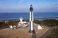
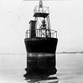
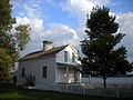
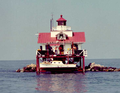
Name Image Location Coordinates Year first lit Automated Year deactivated Current Lens Focal Height Assateague Light Assateague Island 37°54′40″N 75°21′21″W / 37.9111°N 75.3558°W / 37.9111; -75.3558 1833 [ 3] (First) [ 3] (Current) 1933 [ 3] Active DCB-24 154 154 ft (47 m) [ 4] Back River Light Hampton 37°05′14″N 76°16′11″W / 37.0872°N 76.2698°W / 37.0872; -76.2698 1829 1915 1936(Destroyed in 1956 ) None Unknown Bells Rock Light York River 37°29′02″N 76°44′59″W / 37.4839°N 76.7498°W / 37.4839; -76.7498 1881 Never 1928 [ 4] (Dismantled) None 040 40 ft (12 m) [ 4] Bowlers Rock Light Rappahannock River 37°49′28″N 76°43′58″W / 37.8245°N 76.7327°W / 37.8245; -76.7327 1868 [ 5] Never 1920 [ 5] (Removed) None Unknown Cape Charles Light Cape Charles 37°07′22″N 75°54′23″W / 37.1229°N 75.9063°W / 37.1229; -75.9063 1828 [ 6] (First) [ 7] (Current) 1963 [ 7] Active 190mm 180 180 ft (55 m) [ 4] Cape Henry Light (Old) Virginia Beach (Cape Henry ) 36°55′33″N 76°00′29″W / 36.9257°N 76.0081°W / 36.9257; -76.0081 1792 [ 8] Never 1881 [ 8] None Unknown Cape Henry Light (New) Virginia Beach (Cape Henry ) 36°55′35″N 76°00′26″W / 36.9264°N 76.0072°W / 36.9264; -76.0072 1881 [ 9] 1984 [ 9] Active Unknown 157 157 ft (48 m) [ 9] Cherrystone Bar Light Cape Charles (Offshore) 37°15′23″N 76°01′57″W / 37.2564°N 76.0324°W / 37.2564; -76.0324 1858 [ 10] Never 1919 [ 10] (Moved in 1920 ) None Unknown Chesapeake Light Chesapeake Bay (Entrance) 36°54′17″N 75°42′46″W / 36.90472°N 75.71278°W / 36.90472; -75.71278 1965 [ 11] 1980 [ 11] 2016 [ 12] None 117 117 ft (36 m) Craney Island Light Elizabeth River (Mouth) 36°53′31″N 76°20′13″W / 36.892°N 76.337°W / 36.892; -76.337 1859 [ 4] (First) [ 4] (Last) Never 1936 [ 4] (Removed) None 036 36 ft (11 m) Deepwater Shoals Light Newport News (Offshore) 37°8′11.46″N 76°38′12.48″W / 37.1365167°N 76.6368000°W / 37.1365167; -76.6368000 1855 [ 13] (First) [ 13] (Last) Never 1936 [ 13] (Demolished) None 034 34 ft (10 m) [ 4] Dutch Gap Canal Lights James River 37°22′35″N 77°21′34″W / 37.37639°N 77.35944°W / 37.37639; -77.35944 1875 [ 14] Never 1910 [ 14] None 027 27 ft (8.2 m) [ 14] Great Wicomico River Light Great Wicomico River (Mouth) 37°48′15″N 76°16′03″W / 37.8042°N 76.2675°W / 37.8042; -76.2675 1889 [ 15] Never 1967 [ 15] (Dismantled) None 042 42 ft (13 m) [ 4] Hog Island Light (First tower) Exmore 37°23′38″N 75°42′04″W / 37.394°N 75.701°W / 37.394; -75.701 1853 [ 16] Never 1896 [ 17] (Replaced) None Unknown Hog Island Light (Second tower) Exmore 37°23′38″N 75°42′04″W / 37.394°N 75.701°W / 37.394; -75.701 1896 [ 16] Never 1948 [ 17] (Demolished) None Unknown Jones Point Light Alexandria 38°47′25.4″N 77°02′26.3″W / 38.790389°N 77.040639°W / 38.790389; -77.040639 1856 [ 18] 1919 [ 18] Active [ 18] (Inactive: 1926–1995) Unknown 035 35 ft (11 m) [ 18] Jordan Point Front Range Light None Known James River N/A Unknown Unknown Unknown None Unknown Jordan Point Range Rear Light James River 37°18′47″N 77°13′23″W / 37.313°N 77.223°W / 37.313; -77.223 1855 [ 19] (First) (Current) 1941 [ 19] Active Unknown 035 35 ft (11 m) (Second tower) 65 ft (20 m) (Current tower) Killock Shoal Light Chincoteague (Offshore) 37°56′02″N 75°22′48″W / 37.934°N 75.380°W / 37.934; -75.380 1886 [ 20] 1929 1939 [ 20] (Dismantled) None Unknown Lambert Point Light Norfolk 36°52′30″N 76°19′52″W / 36.875°N 76.331°W / 36.875; -76.331 1872 [ 21] Never 1892 [ 21] (Collapsed in 1911) None Unknown Nansemond River Light Nansemond River (Mouth) 36°54′43″N 76°26′42″W / 36.912°N 76.445°W / 36.912; -76.445 1878 [ 22] Never 1935 [ 22] (Dismantled) None Unknown New Point Comfort Light Chesapeake Bay 36°54′43″N 76°26′42″W / 36.912°N 76.445°W / 36.912; -76.445 1805 [ 23] 1930 [ 23] Active [ 24] (Inactive: 1963–1999 [ 23] ) 250mm 058 58 ft (18 m) [ 23] Newport News Middle Ground Light Newport News 36°56′43″N 76°23′29″W / 36.9452°N 76.3915°W / 36.9452; -76.3915 1891 [ 25] 1954 [ 25] Active VRB-25 052 52 ft (16 m) [ 4] Old Plantation Flats Light Cape Charles (Offshore) 37°13′44″N 76°02′49″W / 37.2288°N 76.0469°W / 37.2288; -76.0469 1886 Never 1962(Demolished) None 035 35 ft (11 m) Old Point Comfort Light Hampton 37°00′06″N 76°18′23″W / 37.0018°N 76.3064°W / 37.0018; -76.3064 1804 [ 26] 1972 Active Fourth-order Fresnel [ 4] 054 54 ft (16 m) [ 4] Pages Rock Light York River 37°18′39″N 76°35′12″W / 37.3109°N 76.5866°W / 37.3109; -76.5866 1893 [ 27] 1960 [ 27] 1967 [ 27] (Dismantled) None Unknown Point of Shoals Light James River 37°04′06″N 76°39′11″W / 37.0683°N 76.6530°W / 37.0683; -76.6530 1855 [ 28] (First) [ 28] (Last) 1932 [ 28] 1933 [ 28] (Demolished) None Unknown Pungoteague Creek Light Chesapeake Bay 37°39′47″N 75°53′53″W / 37.6630°N 75.8980°W / 37.6630; -75.8980 1854 [ 29] Never 1856 [ 29] (Destroyed) None Unknown Smith Point Light Potomac River (Mouth) 37°52′48″N 76°11′02″W / 37.8800°N 76.1839°W / 37.8800; -76.1839 1802 [ 30] (First) [ 30] (Current) 1971 [ 30] Active DCB-24 [ 4] 052 52 ft (16 m) [ 4] Stingray Point Light Rappahannock River (Mouth) 37°33′41″N 76°16′12″W / 37.5613°N 76.2700°W / 37.5613; -76.2700 1858 [ 31] 1950 [ 32] 1965 [ 31] (Dismantled) None 034 34 ft (10 m) [ 4] Tangier Sound Light Tangier (Offshore) 37°47′16″N 75°58′26″W / 37.7878°N 75.9740°W / 37.7878; -75.9740 1890 Never 1961(Demolished) None Unknown Thimble Shoal Light Chesapeake Bay 37°00′53″N 76°14′24″W / 37.0146°N 76.2399°W / 37.0146; -76.2399 1872 [ 33] (First) [ 33] (Current) 1964 [ 33] Active RB-355 055 55 ft (17 m) [ 33] Tue Marshes Light York River (Mouth) 37°14′08″N 76°23′09″W / 37.2356°N 76.3859°W / 37.2356; -76.3859 1875 [ 34] Never 1960 [ 34] (Dismantled) None Unknown Watts Island Light Chesapeake Bay 37°46′55″N 75°53′38″W / 37.782°N 75.894°W / 37.782; -75.894 1833 [ 35] 1923 [ 35] 1944 [ 35] (Destroyed) None Unknown White Shoal Light James River 37°01′18″N 76°31′39″W / 37.0218°N 76.5275°W / 37.0218; -76.5275 1855 [ 36] (First) [ 36] (Last) Never 1934 [ 36] (Destroyed in the 1970s) None Unknown Windmill Point Light Rappahannock River (Mouth) 37°35′48″N 76°14′09″W / 37.5968°N 76.2359°W / 37.5968; -76.2359 1869 [ 37] 1954 [ 37] 1965 [ 37] (Dismantled) None Unknown Wolf Trap Light Chesapeake Bay 37°35′48″N 76°14′09″W / 37.5968°N 76.2359°W / 37.5968; -76.2359 1870 [ 38] (First) [ 38] (Current) 1971 [ 38] 2017 [ 4] (Abandoned) VRB-25 Unknown York Spit Light York River (Mouth) 37°12′35″N 76°15′15″W / 37.2096°N 76.2542°W / 37.2096; -76.2542 1870 [ 39] Never 1960 [ 39] (Dismantled) None Unknown