
Mathews County is a county located in the U.S. state of Virginia. As of the 2020 census, the population was 8,533. Its county seat is Mathews.
Hampton is an independent city in the Commonwealth of Virginia in the United States. As of the 2020 census, the population was 137,148. It is the 7th most populous city in Virginia and 204th most populous city in the nation. Hampton is included in the Hampton Roads Metropolitan Statistical Area which is the 37th largest in the United States, with a total population of 1,799,674 (2020). This area, known as "America's First Region", also includes the independent cities of Chesapeake, Virginia Beach, Newport News, Norfolk, Portsmouth, and Suffolk, as well as other smaller cities, counties, and towns of Hampton Roads.

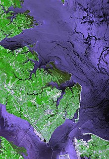
The Virginia Peninsula is a peninsula in southeast Virginia, USA, bounded by the York River, James River, Hampton Roads and Chesapeake Bay. It is sometimes known as the Lower Peninsula to distinguish it from two other peninsulas to the north, the Middle Peninsula and the Northern Neck.

Fort Wool is a decommissioned island fortification located in the mouth of Hampton Roads, adjacent to the Hampton Roads Bridge-Tunnel (HRBT). Now officially known as Rip Raps Island, the fort has an elevation of 7 feet and sits near Old Point Comfort, Old Point Comfort Light, Willoughby Beach and Willoughby Spit, approximately one mile south of Fort Monroe.
The Jones Point Light is a small river lighthouse located on the Potomac River in Alexandria, Virginia. It was built in 1855. It is a small, one-story house with a lantern on top and served primarily as a warning light for naval ships approaching the Washington Navy Yard. The lighthouse was discontinued in 1926, replaced by a small steel skeletal tower located nearby; this smaller tower was in use for ten years before being discontinued. After being dark for more than half a century, Jones Point Light was relit by a private concern in 1995, however, it was eventually put out again after ownership switched from the Daughters of the American Revolution Foundation to the National Park Service. Certain local efforts have called for the structure to be relit, but as of 2017, the only working lighthouse on the Potomac River is the Fort Washington Point Lighthouse, located five miles downriver.

Fort Monroe, managed by partnership between the Fort Monroe Authority for the Commonwealth of Virginia, the National Park Service as the Fort Monroe National Monument, and the City of Hampton, is a former military installation in Hampton, Virginia, at Old Point Comfort, the southern tip of the Virginia Peninsula, United States. Along with Fort Wool, Fort Monroe originally guarded the navigation channel between the Chesapeake Bay and Hampton Roads—the natural roadstead at the confluence of the Elizabeth, the Nansemond and the James rivers. Union General George B. McClellan landed his forces at the fort during Peninsula campaign of 1862 during the American Civil War. Until disarmament in 1946, the areas protected by the fort were the entire Chesapeake Bay and Potomac River regions, including the water approaches to the cities of Washington, D.C. and Baltimore, Maryland, along with important shipyards and naval bases in the Hampton Roads area. Surrounded by a moat, the six-sided bastion fort is the largest fort by area ever built in the United States.
Old Point Comfort is a point of land located in the independent city of Hampton, Virginia. Previously known as Point Comfort, it lies at the extreme tip of the Virginia Peninsula at the mouth of Hampton Roads in the United States. It was renamed Old Point Comfort to differentiate it from New Point Comfort 21 miles (34 km) up the Chesapeake Bay. A group of enslaved Africans was brought to colonial Virginia at this point in 1619. Today the location is home to Continental Park and Fort Monroe National Monument.

Phoebus is a formerly incorporated town located in Elizabeth City County on the Virginia Peninsula in eastern Virginia. Upon incorporation in 1900, it was named in honor of local businessman Harrison Phoebus (1840–1886), who is credited with convincing the Chesapeake and Ohio Railway (C&O) to extend its tracks to the town from Newport News.

Craney Island is a point of land in the independent city of Portsmouth in the South Hampton Roads region of eastern Virginia in the United States. The location, formerly in Norfolk County, is near the mouth of the Elizabeth River opposite Lambert's Point on Hampton Roads. It is home to the Craney Island US Naval Supply Center, managed by the U.S. Army Corps of Engineers.
Harrison Phoebus was an American 19th century entrepreneur and hotelier who became the leading citizen and namesake of the town of Phoebus in Elizabeth City County, near Fort Monroe, which is now part of the independent city of Hampton, Virginia.
Elzy Burroughs (1771/77–1825) was an American stonemason, engineer, lighthouse builder and keeper.

Concord Point Light is a 36-foot (11 m) lighthouse in Havre de Grace, Maryland, United States, overlooking the point where the Susquehanna River flows into the Chesapeake Bay, an area of increasing navigational traffic when it was constructed in 1827. It is the northernmost lighthouse and the second-oldest tower lighthouse still standing on the bay.

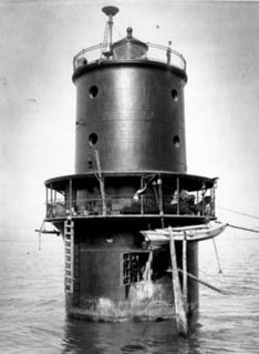
Newport News Middle Ground Light is a lighthouse near the Monitor–Merrimac Memorial Bridge–Tunnel (MMMBT) on Interstate 664 in Hampton Roads. It is the oldest caisson lighthouse in Virginia.

The Turkey Point Light is a historic lighthouse at the head of the Chesapeake Bay. Although only a 35-foot (11 m) tower, the 100-foot (30 m) height of the bluffs on which it stands makes it the third highest light off the water in the bay. It is also known for the large number of women who served as lightkeeper.

The Cove Point Light is a lighthouse located on the west side of Chesapeake Bay in Calvert County, Maryland.

Wolf Trap Light is a caisson lighthouse in the Virginia portion of the Chesapeake Bay, about seven and a half miles northeast of New Point Comfort Light. It is listed on the National Register of Historic Places.

New Point Comfort Light is a lighthouse in the Virginia portion of the Chesapeake Bay, United States, off the tip of the Middle Peninsula. Finished in 1804, it is the third-oldest surviving light in the bay, and the tenth-oldest in the United States.
Thimble Shoal Light is a sparkplug lighthouse in the Virginia portion of Chesapeake Bay, north of the Hampton Roads channel. The third light at this location, it is listed on the National Register of Historic Places.

Smith Point Light is a caisson lighthouse in the Virginia portion of the Chesapeake Bay at the mouth of the Potomac River. It was added to the National Register of Historic Places in 2002.

The Fort Point Light, or Fort Point Light Station, is located in Fort Point State Park, in Stockton Springs, Maine. A lighthouse at this point has served as an active aid to navigation since 1835; the present lighthouse dates to 1857, and is listed on the National Register of Historic Places.


