Cape Hatteras Light is a lighthouse located on Hatteras Island in the Outer Banks in the town of Buxton, North Carolina and is part of the Cape Hatteras National Seashore. It is the tallest lighthouse in the U.S. from base to tip at 210 feet. The lighthouse's semi-unique pattern makes it easy to recognize and famous. It is often ranked high on lists of most beautiful, and famous lighthouses in the US.

The Hereford Inlet Lighthouse is a historic lighthouse located in North Wildwood, New Jersey, situated on the southern shore of Hereford Inlet at the north end of Five Mile Beach. Its construction was completed and it became operational in 1874.

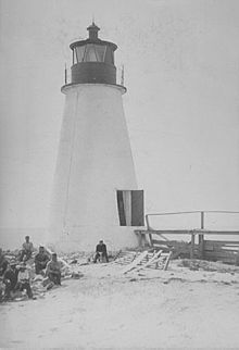
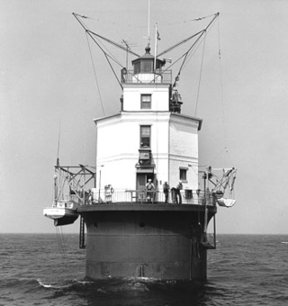
The Seven Foot Knoll Light was built in 1855 and is the oldest screw-pile lighthouse in Maryland. It was located atop Seven Foot Knoll in the Chesapeake Bay until it was replaced by a modern navigational aid and relocated to Baltimore's Inner Harbor as a museum exhibit.
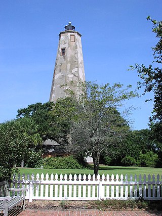
Bald Head Lighthouse, known as Old Baldy, is the oldest lighthouse still standing in North Carolina. It is the second of three lighthouses that have been built on Bald Head Island since the 18th century to help guide ships past the dangerous shoals at the mouth of the Cape Fear river.

The Cape Florida Light is a lighthouse on Cape Florida at the south end of Key Biscayne in Miami-Dade County, Florida. Constructed in 1825, it guided mariners off the Florida Reef, which starts near Key Biscayne and extends southward a few miles offshore of the Florida Keys. It was operated by staff, with interruptions, until 1878, when it was replaced by the Fowey Rocks lighthouse. The lighthouse was put back into use in 1978 by the U.S. Coast Guard to mark the Florida Channel, the deepest natural channel into Biscayne Bay. They decommissioned it in 1990.
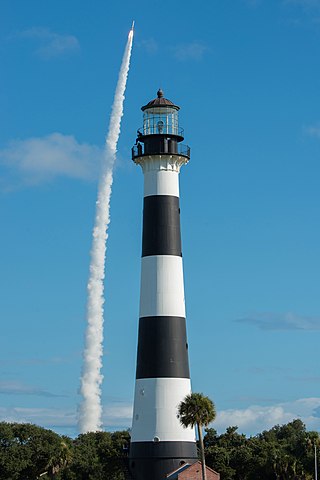
The Cape Canaveral Light is a historic lighthouse on the east coast of the U.S. state of Florida. The light was established in 1848 to warn ships of the dangerous shoals that lie off its coast. It is located inside the Cape Canaveral Space Force Station and managed by the Space Launch Delta 45 of the U.S. Space Force with the assistance of the Cape Canaveral Lighthouse Foundation. It is the only fully operational lighthouse owned by the United States Space Force.

Several lighthouses called Dog Island Light were constructed on the western tip of Dog Island south of Carrabelle, Florida. They marked the "middle entrance to St. George's Sound," between St. George and Dog Islands, during the nineteenth century, until its collapse by a hurricane in 1873.

The Back River is an estuarine inlet of the Chesapeake Bay between the independent cities of Hampton and Poquoson in the Hampton Roads area of southeastern Virginia. Formed by the confluence of the Northwest and Southwest Branches, and at just over two miles (3.2 km) long, the Back River is a breeding ground for many of the Bay's prized sport fish and the well known blue crab. The river was once part of an important fishing area that provided the local canneries with the famous Chesapeake seafood that was, and still is in demand throughout the country. Although now used primarily for recreation and as a wildlife refuge, the river remains a place for fishing and laying crab traps. Factory Point, a peninsula that protects the river from the Chesapeake Bay sits at the mouth of the river adjoining the bay.
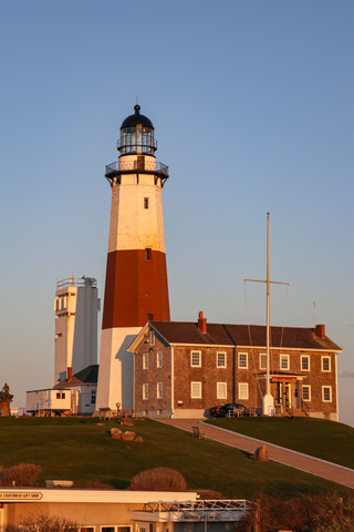
The Montauk Point Light, or Montauk Point Lighthouse, is a lighthouse located adjacent to Montauk Point State Park at the easternmost point of Long Island in Montauk, New York. The lighthouse was the first to be built within the state of New York, and was the first public works project of the new United States. It is the fourth oldest active lighthouse in the United States. Montauk Point Light is listed on the National Register of Historic Places. In 2012, it was designated as a National Historic Landmark for its significance to New York and international shipping in the early Federal period.

The Bodkin Island Light was a lighthouse on the Chesapeake Bay, United States, the first erected in Maryland.
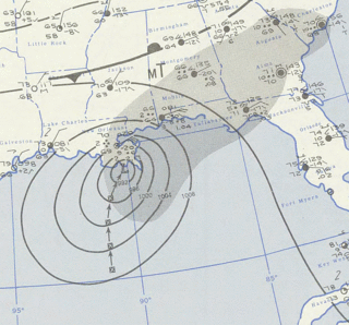
Hurricane Flossy originated from a tropical disturbance in the eastern Pacific Ocean and moved across Central America into the Gulf of Mexico as a tropical depression on September 21, 1956, which became a tropical storm on September 22 and a hurricane on September 23. The hurricane peaked with maximum sustained winds of 90 mph (140 km/h) before it struck the central Gulf coast of the United States as a Category 1 hurricane on September 24, and evolved into an extratropical cyclone on September 25. It was the first hurricane to affect oil refining in the Gulf of Mexico. The tropical cyclone led to flooding in New Orleans, and broke a drought across the eastern United States. The death toll was 15, and total damages reached $24.8 million (1956 USD).
Fort Washington Light is a lighthouse located on the banks of the Potomac River on the grounds of its namesake fort. There has been a lighthouse on the location since 1857; the current light was converted from a fog bell tower in 1901.

The Cove Point Light is a lighthouse located on the west side of Chesapeake Bay in Calvert County, Maryland.

The Watts Island Light was a historic lighthouse located near Watts Island in the Chesapeake Bay. It was the only lighthouse built by John Donahoo outside of Maryland.

New Point Comfort Light is a lighthouse in the Virginia portion of the Chesapeake Bay, United States, off the tip of the Middle Peninsula. Finished in 1804, it is the third-oldest surviving light in the bay, and the tenth-oldest in the United States.
Cape Charles Lighthouse is an octagonal cast iron skeleton tower lighthouse at the mouth of the Chesapeake Bay on Smith Island which was officially removed from service in 2019. It is the tallest lighthouse in Virginia and the second tallest in the United States. This particular tower is the third lighthouse at this location. The first lighthouse at Cape Charles was a 55-foot (17 m) masonry tower completed in 1828. It was quickly deemed inadequate for its important seacoast location due to its low height and poor visibility at sea. It was soon threatened by erosion so in 1864 it was replaced by a 150-foot (46 m) masonry tower built further inland. Located a little more than a mile southwest of the old tower and 600 feet from the shoreline, the impressive 150-foot-tall conical brick tower was similar in appearance to the 1857 Cape May Lighthouse, painted white and topped with a dark brown lantern room. In 1892, a twenty-five-foot red band was painted around the white tower's midsection, about sixty feet up from the base, to make it more visible during the day. By the 1890s, it too was threatened by beach erosion which jetties built to protect it failed to halt, and with the lighthouse now only 300 feet from the ocean and the shoreline eroding at a rate of 37 feet per year it was decided that a third lighthouse needed to be built three quarters of a mile inland.
Smith Point Light is a caisson lighthouse in the Virginia portion of the Chesapeake Bay at the mouth of the Potomac River. It was added to the National Register of Historic Places in 2002.

The Jordan Point Light was a lighthouse located on Jordan Point on the James River in Prince George County, Virginia, near the south end of the present Benjamin Harrison Memorial Bridge.
The Hog Island Light was a lighthouse roughly marking its eponymous island, and thus the north side of the Great Machipongo Inlet on the Virginia coast. Originally, no light existed between Cape Henlopen, Delaware and Cape Charles. In 1830 the United States Congress appropriated money for a coastal beacon in the general vicinity of Chincoteague Island. The following year, the Collector of Customs in Norfolk selected Assateague Island.
Evan O'Neill Kane was an American physician and surgeon from the 1880s to the early 1930s who served as chief of surgery at Kane Summit Hospital in Kane, Pennsylvania. He was a significant contributor in his day to railway surgery; that is, the medical and managerial practices directed toward occupational health and accident-related trauma surgery for railroad workers. Kane was also a well published contributor of innovations in surgical procedures and equipment, including asbestos bandages, mica windows for brain surgery, and multiple site hypodermoclysis.