
The Thomas Point Shoal Light, also known as Thomas Point Shoal Light Station, is a historic lighthouse in the Chesapeake Bay on the east coast of the United States, and the most recognized lighthouse in Maryland. It is the only screw-pile lighthouse in the bay which stands at its original site. The current structure is a 1½ story hexagonal wooden cottage, equipped with a foghorn as well as the light.

Sandy Point Shoal Light is a brick three story lighthouse on a caisson foundation that was erected in 1883. It lies about 0.6 mi (0.97 km) off Sandy Point, north of the Chesapeake Bay Bridge, from whose westbound span it is readily visible.

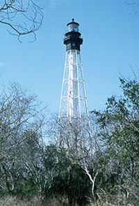
The Turkey Point Light is a historic lighthouse at the head of the Chesapeake Bay. Although only a 35-foot (11 m) tower, the 100-foot (30 m) height of the bluffs on which it stands makes it the third highest light off the water in the bay. It is also known for the large number of women who served as lightkeeper.

Solomons Lump Light is a lighthouse in the Chesapeake Bay, the abbreviated remains of a caisson light built in 1895. That structure replaced a screw-pile light built on the same spot in 1875, which in turn superseded the Fog Point Light.

The Cove Point Light is a lighthouse located on the west side of Chesapeake Bay in Calvert County, Maryland.
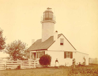
Greenbury Point Light was the name of two lighthouses in the Chesapeake Bay, both located at the mouth of the Severn River in Annapolis, Maryland.
The Lower Cedar Point Light was a historic lighthouse in the Potomac River near its eponymous point, south of the present Governor Harry W. Nice Memorial Bridge, which carries U.S. Route 301 between Maryland and Virginia. It has been replaced by a skeleton tower.
Fort Carroll Light is a derelict lighthouse consisting of a short wooden tower on the walls of its namesake fortifications in the Patapsco River.

The Craighill Channel Upper Range Rear Light is one of a pair of range lights that marks the second section of the shipping channel into Baltimore harbor.

Wolf Trap Light is a caisson lighthouse in the Virginia portion of the Chesapeake Bay, about seven and a half miles northeast of New Point Comfort Light. It is listed on the National Register of Historic Places.

New Point Comfort Light is a lighthouse in the Virginia portion of the Chesapeake Bay, United States, off the tip of the Middle Peninsula. Finished in 1804, it is the third-oldest surviving light in the bay, and the tenth-oldest in the United States.
Cape Charles Lighthouse is an octagonal cast iron skeleton tower lighthouse at the mouth of the Chesapeake Bay on Smith Island which was officially removed from service in 2019. It is the tallest lighthouse in Virginia and the second tallest in the United States. This particular tower is the third lighthouse at this location. The first lighthouse at Cape Charles was a 55-foot (17 m) masonry tower completed in 1828. It was quickly deemed inadequate for its important seacoast location due to its low height and poor visibility at sea. It was soon threatened by erosion so in 1864 it was replaced by a 150-foot (46 m) masonry tower built further inland. Located a little more than a mile southwest of the old tower and 600 feet from the shoreline, the impressive 150-foot-tall conical brick tower was similar in appearance to the 1857 Cape May Lighthouse, painted white and topped with a dark brown lantern room. In 1892, a twenty-five-foot red band was painted around the white tower's midsection, about sixty feet up from the base, to make it more visible during the day. By the 1890s, it too was threatened by beach erosion which jetties built to protect it failed to halt, and with the lighthouse now only 300 feet from the ocean and the shoreline eroding at a rate of 37 feet per year it was decided that a third lighthouse needed to be built three quarters of a mile inland.

The Bells Rock Light was a lighthouse located in the York River in Virginia.

The Tue Marshes Light was a lighthouse located at the mouth of the York River in the Chesapeake Bay north of Tue Point near the Goodwin Islands.

The Fort Point Light, or Fort Point Light Station, is located in Fort Point State Park, in Stockton Springs, Maine. A lighthouse at this point has served as an active aid to navigation since 1835; the present lighthouse dates to 1857, and is listed on the National Register of Historic Places.

Annisquam Harbor Light Station is a historic lighthouse on Wigwam Point in the Annisquam neighborhood of Gloucester, Massachusetts. It can be viewed from nearby Wingaersheek Beach, Gloucester. It lies on the Annisquam River and is one of the four oldest lighthouses to surround the Gloucester peninsula as well as; Eastern Point Light, Ten Pound Island Light, and Thacher Island Light.

Little River Light is a lighthouse on an island at the mouth of the Little River, in Cutler, Maine. A light station was first established at this site in 1846, and the present structure was built in 1876. It is one of the only iron lighthouses in the state, and was listed on the National Register of Historic Places as Little River Light Station on March 14, 1988. The light station is now owned by the American Lighthouse Foundation, which offers overnight stays in the keeper's house, and occasional tours of the property.

Perkins Island Light is a lighthouse on the Kennebec River in Maine. It was established in 1898, as part of a major upgrade of the river's lights — the Doubling Point Light and the separate Range Lights on the point, Perkins Island Light, and Squirrel Point Light were all built at the same time. It was listed on the National Register of Historic Places as Perkins Island Light Station in 1988.
The Dutch Gap Canal Lights were built to mark the ends of Dutch Gap Canal, now called Dutch Gap Cutoff, which is a 3⁄4 nautical mile cut across the base of an oxbow in the James River between Hopewell and Richmond, Virginia. They were on Farrar's Island, on the south side of the river.


