
Portland Head Light is a historic lighthouse in Cape Elizabeth, Maine. The light station sits on a headland at the entrance of the primary shipping channel into Portland Harbor, which is within Casco Bay in the Gulf of Maine. Completed in 1791, it is the oldest lighthouse in Maine. The light station is automated, and the tower, beacon, and foghorn are maintained by the United States Coast Guard, while the former lighthouse keeper's house is a maritime museum within Fort Williams Park.

Chatham Lighthouse, known as Twin Lights prior to 1923, is a lighthouse in Chatham, Massachusetts, near the "elbow" of Cape Cod. The original station, close to the shore, was built in 1808 with two wooden towers, which were both replaced in 1841. In 1877, two new towers, made of cast iron rings, replaced those. One of the towers was moved to the Eastham area, where it became known as Nauset Light in 1923.
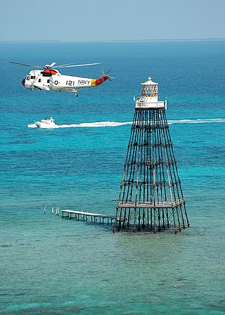
Sand Key Light is a lighthouse 6 nautical miles southwest of Key West, Florida, between Sand Key Channel and Rock Key Channel, two of the channels into Key West, on a reef intermittently covered by sand. At times the key has been substantial enough to have trees, and in 1900 nine to twelve thousand terns nested on the island. At other times the island has been washed away completely. The light marks the southernmost point of the Hawk Channel passage along the Florida Keys.

Brant Point Light is a lighthouse located on Nantucket Island. The station was established in 1746, automated in 1965, and is still in operation. The current tower was added to the National Register of Historic Places on October 28, 1987; it has the distinction of being the tenth light on the point, in addition to several range lights. Four of the others burned or blew down, two were condemned, two were unsatisfactory, and the remaining one stands unused.

Penfield Reef Lighthouse is a lighthouse in Connecticut, United States, on Penfield Reef at the south side of Black Rock Harbor entrance on the Long Island Sound, off the coast of Fairfield, Connecticut. Constructed in 1874, it was one of the last offshore masonry lights. Most offshore lights built after this were cast iron towers built on cylindrical cast iron foundations.

New Point Comfort Light is a lighthouse in the Virginia portion of the Chesapeake Bay, United States, off the tip of the Middle Peninsula. Finished in 1804, it is the third-oldest surviving light in the bay, and the tenth-oldest in the United States.
Cape Charles Lighthouse is an octagonal cast iron skeleton tower lighthouse at the mouth of the Chesapeake Bay on Smith Island which was officially removed from service in 2019. It is the tallest lighthouse in Virginia and the second tallest in the United States. This particular tower is the third lighthouse at this location. The first lighthouse at Cape Charles was a 55-foot (17 m) masonry tower completed in 1828. It was quickly deemed inadequate for its important seacoast location due to its low height and poor visibility at sea. It was soon threatened by erosion so in 1864 it was replaced by a 150-foot (46 m) masonry tower built further inland. Located a little more than a mile southwest of the old tower and 600 feet from the shoreline, the impressive 150-foot-tall conical brick tower was similar in appearance to the 1857 Cape May Lighthouse, painted white and topped with a dark brown lantern room. In 1892, a twenty-five-foot red band was painted around the white tower's midsection, about sixty feet up from the base, to make it more visible during the day. By the 1890s, it too was threatened by beach erosion which jetties built to protect it failed to halt, and with the lighthouse now only 300 feet from the ocean and the shoreline eroding at a rate of 37 feet per year it was decided that a third lighthouse needed to be built three quarters of a mile inland.

The Jordan Point Light was a lighthouse located on Jordan Point on the James River in Prince George County, Virginia, near the south end of the present Benjamin Harrison Memorial Bridge.

The Fort Point Light, or Fort Point Light Station, is located in Fort Point State Park, in Stockton Springs, Maine. A lighthouse at this point has served as an active aid to navigation since 1835; the present lighthouse dates to 1857, and is listed on the National Register of Historic Places.
Isle au Haut Light, also called Robinson Point Light, is a lighthouse located at Robinson Point in Isle au Haut, Maine. The lighthouse was established in 1907.

Marshall Point Light Station is a lighthouse at the entrance of Port Clyde Harbor in Port Clyde, Maine. The light station was established in 1832.

The Doubling Point Range Lights are a pair of range lights on the Kennebec River, in Arrowsic, Maine. Built in 1898 as part of a major improvement on navigational aids on the river, they are the only surviving pair of range lights in the state. They were listed on the National Register of Historic Places as Kennebec River Light Station on January 21, 1988.

Doubling Point Light is a lighthouse on the Kennebec River in Arrowsic, Maine. It was established in 1898, fifteen years after the founding of the Bath Iron Works, a major shipbuilder, 1.5 miles (2.4 km) upriver. It was part of a major upgrade of the river's lights — the Doubling Point Light and the separate Range Lights on the point, Perkins Island Light, and Squirrel Point Light were all built at the same time. The light was listed on the National Register of Historic Places as Doubling Point Light Station on January 21, 1988. It remains an active aid to navigation.

Perkins Island Light is a lighthouse on the Kennebec River in Maine. It was established in 1898, as part of a major upgrade of the river's lights — the Doubling Point Light and the separate Range Lights on the point, Perkins Island Light, and Squirrel Point Light were all built at the same time. It was listed on the National Register of Historic Places as Perkins Island Light Station in 1988.
Squirrel Point Light is a lighthouse marking the southwestern point of Arrowsic Island on the Kennebec River. It was established in 1898, as part of a major upgrade of the river's lights — the Doubling Point Light and the separate Range Lights on the point, Perkins Island Light, and Squirrel Point Light were all built at the same time. The light station was listed on the National Register of Historic Places as Squirrel Point Light Station on January 21, 1988.

Richmond River Light, also known as Ballina Head Light and Ballina Light, is an active lighthouse located at Ballina Head, a headland in Ballina, New South Wales, Australia. The headland is at the northern side of the entrance to the Richmond River. It used to serve to guide ships into the river port and is used also serves as a leading light into the river, together with a steamer's masthead lantern with a 200 mm lens which is raised on a wooden structure 30 metres (98 ft) from it.

Rawley Point Light is a lighthouse located in Point Beach State Forest, near Two Rivers, Wisconsin. At 111 feet (34 m) tall, it is the tallest lighthouse on the Wisconsin Shore and it is listed on the National Register of Historic Places.
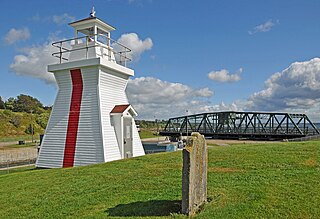
Balache Point Lighthouse, also known as Balache Point Range Rear Lighthouse, is an active Canadian lighthouse located next to the Canso Canal, near Port Hastings, Inverness County, Nova Scotia. The salt shaker style light, which sits on a small hillock on the Cape Breton side of the canal, is the second lighthouse to be built on the site.
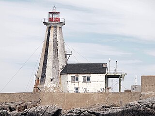
The Gannet Rock Lighthouse is a Canadian lighthouse located on a rocky islet 8 miles (13 km) south of Grand Manan in the Bay of Fundy. It was first lit in 1831 and was staffed until 1996. It was solarized in 2002 and remains operational in 2023. It was declared "surplus to requirements" by the Canadian Coast Guard in 2010 and is no longer being maintained.

