
Suffolk is an independent city in the Commonwealth of Virginia, and as such has no county. As of the 2020 census, the population was 94,324. It is the 9th most populous city in Virginia and the largest city in Virginia by boundary land area as well as the 14th largest in the country.

South Hampton Roads is a region located in the extreme southeastern portion of Virginia's Tidewater region in the United States with a total population of 1,191,937. It is part of the Virginia Beach-Norfolk-Newport News, VA-NC MSA, which itself has a population of 1,724,876.

Newport News Middle Ground Light is a lighthouse near the Monitor–Merrimac Memorial Bridge–Tunnel (MMMBT) on Interstate 664 in Hampton Roads. It is the oldest caisson lighthouse in Virginia.

Solomons Lump Light is a lighthouse in the Chesapeake Bay, the abbreviated remains of a caisson light built in 1895. That structure replaced a screw-pile light built on the same spot in 1875, which in turn superseded the Fog Point Light.

The Choptank River Light was a screw-pile lighthouse located near Oxford, Maryland. In its second incarnation it was the only such light moved from another location in the Chesapeake Bay.
The Lower Cedar Point Light was a historic lighthouse in the Potomac River near its eponymous point, south of the present Governor Harry W. Nice Memorial Bridge, which carries U.S. Route 301 between Maryland and Virginia. It has been replaced by a skeleton tower.

The Pages Rock Light was a lighthouse located in the York River in the Chesapeake Bay.

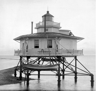
Wolf Trap Light is a caisson lighthouse in the Virginia portion of the Chesapeake Bay, about seven and a half miles northeast of New Point Comfort Light. It is listed on the National Register of Historic Places.

New Point Comfort Light is a lighthouse in the Virginia portion of the Chesapeake Bay, United States, off the tip of the Middle Peninsula. Finished in 1804, it is the third-oldest surviving light in the bay, and the tenth-oldest in the United States.

Thimble Shoal Light is a sparkplug lighthouse in the Virginia portion of Chesapeake Bay, north of the Hampton Roads channel. The third light at this location, it is listed on the National Register of Historic Places.

The Deepwater Shoals Light was a lighthouse located in the James River upstream from Newport News, Virginia.

The White Shoal Light was a lighthouse located in the James River near Newport News, Virginia. It outlasted all other lighthouses in the James, finally succumbing to ice in the 1970s.
The Point of Shoals Light was a lighthouse located in the James River in Virginia.

The Bells Rock Light was a lighthouse located in the York River in Virginia.

The Tue Marshes Light was a lighthouse located at the mouth of the York River in the Chesapeake Bay north of Tue Point near the Goodwin Islands.

The Great Wicomico River Light was a lighthouse located at the mouth of the Great Wicomico River, south of the Potomac River on the western side of the Chesapeake Bay. It was first lit in 1889 and was deactivated in 1967.

The Bowlers Rock Light was a lighthouse located in the Rappahannock River in Virginia, United States.

The Cherrystone Bar Light was a lighthouse located at the entrance to Cape Charles, Virginia harbor in the Chesapeake Bay. It was the only light in the bay moved to another location, becoming the Choptank River Light in 1921.

Chesapeake Light is an offshore lighthouse marking the entrance to the Chesapeake Bay. The structure was first marked with a lightship in the 1930s, and was later replaced by a "Texas Tower" in 1965. The lighthouse was eventually automated and was used for supporting atmospheric measurement sites for NASA and NOAA. Due to deteriorating structural conditions, the lighthouse was deactivated in 2016. At the time it was the last remaining "Texas Tower" still in use due to obsolescence.


