The 1959 Atlantic hurricane season had a then record-tying number of tropical cyclones – five – develop before August 1. The season was officially to begin on June 15, 1959 and last until November 15, 1959, the period of each year when most tropical cyclones form in the Atlantic basin, however in actuality the season began early when Tropical Storm Arlene formed on May 28. Tropical Storm Arlene struck Louisiana and brought minor flooding to the Gulf Coast of the United States. The next storm, Beulah, formed in the western Gulf of Mexico and brought negligible impact to Mexico and Texas. Later in June, an unnamed hurricane, nicknamed the Escuminac disaster, caused minor damage in Florida and devastated coastal Nova Scotia and New Brunswick, after becoming extratropical. Hurricane Cindy brought minor impact to The Carolinas. In late July, Hurricane Debra produced flooding in the state of Texas. Tropical Storm Edith in August and Hurricane Flora in September caused negligible impact on land.

The 1975 Atlantic hurricane season featured the first tropical storm to be upgraded to a hurricane based solely on satellite imagery – Hurricane Doris. The season officially began on June 1 and lasted until November 30. These dates conventionally delimit the period of each year when most tropical cyclones form in the Atlantic basin. The season was near average, with nine tropical storms forming, of which six became hurricanes. Three of those six became major hurricanes, which are Category 3 or higher on the Saffir–Simpson scale. The first system, Tropical Depression One, developed on June 24. Tropical Storm Amy in July caused minor beach erosion and coastal flooding from North Carolina to New Jersey, and killed one person when a ship capsized offshore North Carolina. Hurricane Blanche brought strong winds to portions of Atlantic Canada, leaving about $6.2 million (1975 USD) in damage. Hurricane Caroline brought high tides and flooding to northeastern Mexico and Texas, with two drownings in the latter.

The 1985 Atlantic hurricane season had six United States landfalling hurricanes, tied with 1886 and 2020 for the highest number on record. The season officially began on June 1 and lasted until November 30. It was an average season, with 11 named storms developing. This was partially attributed to a La Niña – a meteorological phenomenon that produces favorable conditions across the Atlantic basin, such as lower wind shear and higher sea surface temperatures. The first storm, Ana, developed on July 15 near Bermuda and caused minor effects in Canada while transitioning into an extratropical cyclone. Three other tropical cyclones – Claudette, Henri, and Isabel – did not significantly affect land. Claudette developed offshore of the Southeastern United States and brushed Bermuda and the Azores. Henri and Isabel were dissipating as they approached land. However, the precursor of the latter caused a severe flood in Puerto Rico that killed 180 people. Additionally, Tropical Storm Fabian and three tropical depressions did not have any known impact on land.

Hurricane Hilda was an intense tropical cyclone that ravaged areas of the United States Gulf Coast, particularly Louisiana. In addition to its damage inland, the hurricane greatly disrupted offshore oil production, and at its time was the costliest tropical cyclone for Louisiana's offshore oil production. Due in part to flights made by the National Hurricane Research Laboratory, Hilda became one of the most well-documented storms meteorologically in the Atlantic. Lasting for seven days as a tropical cyclone, Hilda caused US$126 million in damage and 38 deaths. It was the tenth named storm, sixth hurricane, and the fourth major hurricane of the 1964 Atlantic hurricane season.

The 1957 Atlantic hurricane season featured one of the longest-travelling tropical cyclones in the Atlantic basin, Hurricane Carrie. Nevertheless, the season was generally inactive, with eight tropical storms – two of which went unnamed – and three hurricanes, two of which intensified further to attain major hurricane intensity. The season officially began on June 15 and ended on November 15, though the year's first tropical cyclone developed prior to the start of the season on June 8. The final storm dissipated on October 27, well before the official end of the season. The strongest hurricane of the year was Carrie, which reached the equivalent of a Category 4 hurricane on the Saffir–Simpson hurricane scale on two separate occasions in the open Atlantic; Carrie later caused the sinking of the German ship Pamir southwest of the Azores, resulting in 80 deaths.

The 1956 Atlantic hurricane season featured a decent number of tropical cyclones, although most tropical storms and hurricanes affected land. There were twelve tropical storms, a third of which became hurricanes. One of the hurricanes strengthened to the equivalent of a major hurricane, which is a Category 3 or greater on the Saffir–Simpson scale. The strongest hurricane of the season was Betsy, which was also the most damaging storm of the season: it destroyed 15,000 houses and left $40 million in damage in Puerto Rico. Betsy was also the deadliest of the season, having killed 18 people in the French West Indies, two from a shipwreck in the Caribbean Sea, and 16 in Puerto Rico. Tropical Storm Dora struck Mexico in September and killed 27 people.

The 1949 Atlantic hurricane season was the last season that tropical cyclones were not publicly labeled by the United States Weather Bureau. It officially began on June 15, and lasted until November 15. These dates conventionally delimit the period of each year when most tropical cyclones form in the Atlantic basin. The first storm, a tropical depression, developed in the northern Gulf of Mexico on August 14. The final system, Tropical Storm Sixteen, dissipated in the southwestern Caribbean Sea on November 5. It was a fairly active season, featuring 16 tropical storms and seven hurricanes. Two of these strengthened into major hurricanes, which are Category 3 or higher on the Saffir–Simpson hurricane wind scale.

The 1945 Atlantic hurricane season produced multiple landfalling tropical cyclones. It officially began on June 16 and lasted until October 31, dates delimiting the period when a majority of storms were perceived to form in the Atlantic Ocean. A total of 11 systems were documented, including a late-season cyclone retroactively added a decade later. Five of the eleven systems intensified into hurricanes, and two further attained their peaks as major hurricanes. Activity began with the formation of a tropical storm in the Caribbean on June 20, which then made landfalls in Florida and North Carolina at hurricane intensity, causing one death and at least $75,000 in damage. In late August, a Category 3 hurricane on the modern-day Saffir–Simpson hurricane wind scale struck the Texas coastline, with 3 deaths and $20.1 million in damage. The most powerful hurricane of the season, reaching Category 4 intensity, wrought severe damage throughout the Bahamas and East Coast of the United States, namely Florida, in mid-September; 26 people were killed and damage reached $60 million. A hurricane moved ashore the coastline of Belize in early October, causing one death, while the final cyclone of the year resulted in 5 deaths and $2 million in damage across Cuba and the Bahamas two weeks later. Overall, 36 people were killed and damage reached at least $82.85 million.

The 1936 Atlantic hurricane season was fairly active, with 20 tropical cyclones recorded, 17 of which became tropical storms. Seven storms became hurricanes, of which one became a major hurricane. In addition, the season was unusual in the fact that no storms moved across large portions of the Caribbean Sea. Seven storms, including three hurricanes, struck the United States.

The 1921 Atlantic hurricane season featured the most recent major hurricane to strike the Tampa Bay area in Florida. Although no "hurricane season" was defined at the time, the present-day delineation of such is June 1 to November 30. The first system, a tropical depression, developed on June 1, while the last, a tropical storm, dissipated on November 25. Of note, three of the twelve cyclones co-existed with another tropical cyclone during the season.

The 1897 Atlantic hurricane season was an inactive season, featuring only six known tropical cyclones, four of which made landfall. There were three hurricanes, none of which strengthened into major hurricanes, which are Category 3 or higher on the modern-day Saffir–Simpson hurricane wind scale. The first system was initially observed south of Cape Verde on August 31, an unusually late date. The storm was the strongest of the season, peaking as a Category 2 hurricane with winds of 100 mph (155 km/h). While located well north of the Azores, rough seas by the storm sunk a ship, killing all 45 crewmen. A second storm was first spotted in the Straits of Florida on September 10. It strengthened into a hurricane and tracked northwestward across the Gulf of Mexico, striking Louisiana shortly before dissipating on September 13. This storm caused 29 deaths and $150,000 (1897 USD) in damage.
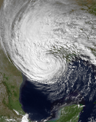
Hurricane Juan was a large and erratic tropical cyclone that looped twice near the Louisiana coast, causing widespread flooding. It was the tenth named storm of the 1985 Atlantic hurricane season, forming in the central Gulf of Mexico in late October. Juan moved northward after its formation, and was subtropical in nature with its large size. On October 27, the storm became a hurricane, reaching maximum sustained winds of 85 mph (140 km/h). Due to the influence of an upper-level low, Juan looped just off southern Louisiana before making landfall near Morgan City on October 29. Weakening to tropical storm status over land, Juan turned back to the southeast over open waters, crossing the Mississippi River Delta. After turning to the northeast, the storm made its final landfall just west of Pensacola, Florida, late on October 31. Juan continued quickly to the north and was absorbed by an approaching cold front, although its moisture contributed to a deadly flood event in the Mid-Atlantic states.

The 1885 Atlantic hurricane season ran through the summer and the first half of fall in 1885. This is the period of each year when most tropical cyclones form in the Atlantic basin. In 1885 there were two tropical storms and six hurricanes in the Atlantic basin. However, in the absence of modern satellite monitoring and remote-sensing technologies, only storms that affected populated land areas or encountered ships at sea were recorded, so the actual total could be higher. An undercount bias of zero to six tropical cyclones per year between 1851 and 1885 and zero to four per year between 1886 and 1910 has been estimated.

Hurricane Audrey was one of the deadliest tropical cyclones in U.S. history, killing at least 416 people in its devastation of the southwestern Louisiana coast in 1957. Along with Hurricane Alex in 2010, it was also the strongest June hurricane ever recorded in the Atlantic basin as measured by pressure. The rapidly developing storm struck southwestern Louisiana as an intense Category 3 hurricane, destroying coastal communities with a powerful storm surge that penetrated as far as 20 mi (32 km) inland. Audrey was the first named storm and hurricane of the 1957 hurricane season. It formed on June 24 from a tropical wave that moved into the Bay of Campeche. Situated within ideal conditions for tropical development, Audrey quickly strengthened, reaching hurricane status a day afterwards. Moving north, it continued to strengthen and accelerate as it approached the United States Gulf Coast. On June 27, the hurricane reached peak sustained winds of 125 mph (205 km/h), making it a major hurricane. At the time, Audrey had a minimum barometric pressure of 946 mbar. The hurricane made landfall with the same intensity between the mouth of the Sabine River and Cameron, Louisiana, later that day, causing unprecedented destruction across the region. Once inland, Audrey weakened and turned extratropical over West Virginia on June 29. Audrey was the first major hurricane to form in the gulf of Mexico since 1945.
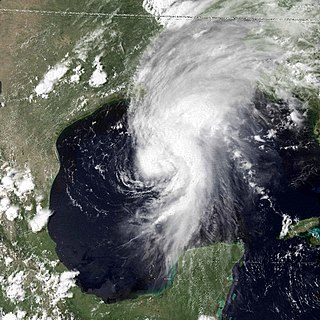
Hurricane Bob was the first Atlantic tropical cyclone to be officially designated using a masculine name after the discontinuation of Joint Army/Navy Phonetic Alphabet names. Bob brought moderate damage to portions of the United States Gulf Coast and areas farther inland in July 1979. The storm was the first hurricane in the Gulf of Mexico to form in the month of July since 1959, and was the fifth tropical cyclone to form during the annual hurricane season. Though the origin of Bob can be traced back to a tropical wave near the western coast of Africa in late June, Bob formed from a tropical depression in the southwestern Gulf of Mexico on July 9. Tracking in a general northward direction, favorable conditions allowed for quick strengthening. Less than a day after formation, the system reached tropical storm intensity, followed by hurricane intensity on July 11. Shortly after strengthening into a hurricane, Bob reached its peak intensity with maximum sustained winds of 75 mph (121 km/h) and a minimum barometric pressure of 986 mbar. At the same intensity, Bob made landfall west of Grand Isle, Louisiana, and rapidly weakened after moving inland. However, the resulting tropical depression persisted for several days as it paralleled the Mississippi and Ohio rivers. On July 16, the system emerged into the western Atlantic, where it was subsequently absorbed by a nearby low-pressure area.

Tropical Storm Chris caused minor flooding along the Gulf Coast of the United States in September 1982. The fifth tropical or subtropical cyclone and third named storm of the 1982 Atlantic hurricane season, Chris developed from a surface low-pressure area in the northern Gulf of Mexico on September 9. Although initially displaying subtropical characteristics, the low pressure area gradually acquired tropical characteristics, and was reclassified as Tropical Depression Four within 24 hours of development. The depression then began to intensify and was upgraded to Tropical Storm Chris on September 10. Thereafter, the storm turned north-north-eastward and strengthened further. On September 11, Chris peaked as a 65 mph (100 km/h) tropical storm. Later that day, it made landfall near Sabine Pass, Port Arthur, Texas. By September 13, Chris dissipated over Arkansas.

Tropical Storm Debbie of the 1965 Atlantic hurricane season broke the daily rainfall record in Mobile, Alabama, despite dissipating offshore. It developed on September 24 in the western Caribbean Sea, and moved northwestward for several days without intensifying. On September 27, Debbie turned toward the northeast in the Gulf of Mexico, and the next day briefly attained tropical storm status. However, the intrusion of cooler air imparted weakening, and the storm dissipated on September 30 just off the east coast of Louisiana. It initially threatened areas of Louisiana that sustained significant damage from Hurricane Betsy in early September, although Debbie only caused light rainfall and some flooding in the state. In southern Alabama, the storm dropped 17.2 in (440 mm) of rainfall, which resulted in significant flooding of roads and cars. Damage totaled $25 million in the Mobile, Alabama area, although there was little damage elsewhere.

The 1901 Louisiana hurricane was the first hurricane to make landfall in Louisiana in the month of August or earlier since 1888. The fourth tropical cyclone and second hurricane of the season, this storm developed southwest of the Azores on August 2. Moving southwestward and later westward, the depression remained weak for several days, until strengthening into a tropical storm while approaching the Bahamas early on August 9. It then crossed through the islands and intensified only slightly. Late on August 10, the storm made landfall near Deerfield Beach, Florida. After reaching the Gulf of Mexico the next day, continuous intensifying occurred and by August 12, the storm reached hurricane status. Peaking with winds of 90 mph (145 km/h), it struck Louisiana late on August 14 and then Mississippi less than 24 hours later. The system weakened to a tropical storm early on August 16 and became extratropical several hours later.


