Boonton is a town in Morris County, in the U.S. state of New Jersey. As of the 2020 United States census, the town's population was 8,815, an increase of 468 (+5.6%) from the 2010 census count of 8,347, which in turn reflected a decline of 149 (−1.8%) from the 8,496 counted in the 2000 census. The settlement was originally called "Boone-Towne" in 1761 in honor of the Colonial Governor Thomas Boone.

Boonton Township is a township in Morris County, in the U.S. state of New Jersey. As of the 2020 United States census, the township's population was 4,380, an increase of 117 (2.7%) from the 2010 census count of 4,263, which in turn reflected a decline of 24 (−0.6%) from 4,287 in the 2000 census.

The Rockaway River is a tributary of the Passaic River, approximately 35 mi (56 km) long, in Morris County, New Jersey in the United States. The upper course of the river flows through a wooded mountainous valley, whereas the lower course flows through the populated New Jersey suburbs and former industrial area west of New York City. It drains an area of approximately 130 sq mi (340 km²).

The Main Line is a commuter rail line owned and operated by New Jersey Transit running from Suffern, New York to Hoboken, New Jersey, in the United States. It runs daily commuter service and was once the north–south main line of the Erie Railroad. It is colored yellow on NJ Transit system maps, and its symbol is a water wheel.
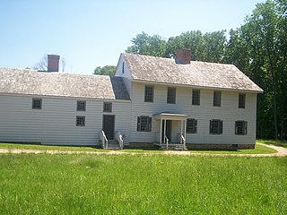
Rockingham is a historic house that was the home of John Berrien (1711–1772) and George Washington's final headquarters of the Revolutionary War. It is located at 84 Laurel Avenue, Franklin Township in Somerset County, New Jersey. The house was originally located on the hillside east of the Millstone River at Rocky Hill. It has been moved within southern Franklin Township several times, and is now closer to Kingston than to Rocky Hill. The residence is a featured part of the Millstone River Valley Scenic Byway. The oldest portion of the house was built as a two-room, two-story saltbox style house c. 1710; a kitchen and additional rooms were added on in the early 1760s, expanding with the Berrien family. The first reference to the house as "Rockingham" does not appear until a 1783 newspaper advertisement to sell the house, a name given most likely in honor of the Marquess of Rockingham.

Denville is an active commuter railroad train station in Denville Township, Morris County, New Jersey. Located on Estling Road, the station contains three side platforms–two curved low-level platforms that service New Jersey Transit's Morristown Line, and a third that services their Montclair-Boonton Line. Both platforms on the Morristown Line contain miniature high-level platforms for handicap accessibility. Trains on both lines operate between Hoboken Terminal, New York Penn Station and Hackettstown. Heading westbound, the next station is Dover while the next station east on the Morristown Line is Mount Tabor. The next station east on the Montclair-Boonton Line is Mountain Lakes.

Dover is an active commuter railroad train station in the borough of Dover, Morris County, New Jersey. Located at the end of electric service, Dover station serves as a secondary terminal of NJ Transit's Morristown and Montclair-Boonton Lines. Non-electric service continues west to Hackettstown on both lines. The next station to the west is Mount Arlington while the next station to the east is Denville. Dover station consists of a single island platform, accessible for the handicapped.

Boonton is a NJ Transit station in Boonton, Morris County, New Jersey, United States along the Montclair-Boonton Line. It is located on Main Street, near Myrtle Avenue and I-287. The original 1905 station was built by architect Frank J. Nies who built other stations for the Delaware, Lackawanna and Western Railroad. Unlike most of his stations which tended to be massive Renaissance structures, Boonton station was built as a simple Prairie House design. The station house is now a bar, and was added to the National Register of Historic Places on July 13, 1977, two years before the establishment of New Jersey Transit and six years before becoming part of their railroad division.

Mountain Lakes is a commuter railroad station in the borough of Mountain Lakes, Morris County, New Jersey, United States. Serviced by New Jersey Transit's Montclair-Boonton Line, the station is the first/last station after the Morristown Line merges/diverges at Denville station. The station consists of one low-level side platform, servicing a solo track. A station depot, built by the Delaware, Lackawanna and Western Railroad, is located in the parking lot, currently serving as a restaurant known as "The Station at Mountain Lakes".
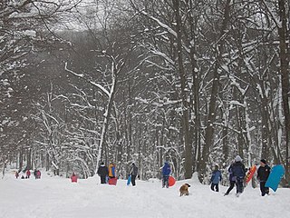
Tourne County Park is a county park in Morris County, New Jersey, United States. The park covers 547 acres (2.2 km²) in four different municipalities, Mountain Lakes, Denville, Boonton Township, and Parsippany. It includes bike trails, equestrian trails, hiking trails, picnic areas and play areas. Sledding and cross-country skiing are also allowed in the winter. Hiking and biking are the most common activity at this park with several miles of gravel trails that climb a small mountain that has scenic views of the Rockaway Valley and east to New York City, which locals dubbed "The New York Overlook". The top of The Tourne is a great place to stop after a hard hike or ride and also has a 9/11 memorial to honor the fallen.
Dixon House may refer to:
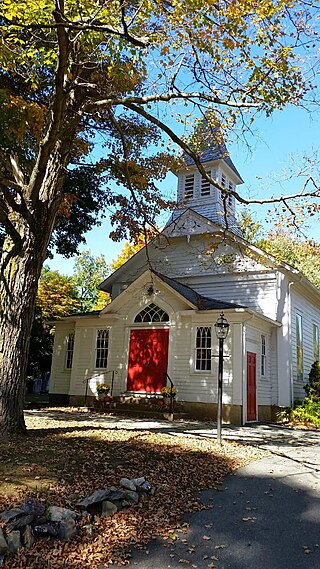
Rockaway Valley Methodist Church is a historic church located on Valley Road, northwest of Boonton, in Boonton Township of Morris County, New Jersey.

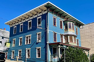
Miller-Kingsland House is located in Boonton, Morris County, New Jersey, United States. The house was built in 1740 and added to the National Register of Historic Places on July 24, 1973.

Frank J. Nies was an American architect best known for having designed numerous Delaware, Lackawanna and Western Railroad stations, at least fifteen of which have been listed on the U.S. National Register of Historic Places : He sometimes worked with the railroad's chief engineer, Lincoln Bush. Before working for the Delaware, Lackawanna & Western, Nies was a partner in the architectural firm Finkler & Nies, with Adolph Finkler, in Chicago in 1896.

The Jacob Wise Neighbor House is a historic house built c. 1830 and located at 143 West Mill Road near Long Valley in Washington Township, Morris County, New Jersey. The J. W. Neighbor House was added to the National Register of Historic Places on February 22, 1991, for its significance in architecture. The 3.5-acre (1.4 ha) property overlooks the valley formed by the South Branch Raritan River. It is now the Neighbour House Bed & Breakfast.

The Leonard Neighbor Farmstead is a historic house located at 177 West Mill Road near Long Valley in Washington Township, Morris County, New Jersey. It was added to the National Register of Historic Places on May 1, 1992, for its significance in architecture. The farm overlooks the valley formed by the South Branch Raritan River. The house is part of the Stone Houses and Outbuildings in Washington Township Multiple Property Submission (MPS).

The Sharpenstine Farmstead is a historic farmhouse located at 98 East Mill Road near Long Valley in Washington Township, Morris County, New Jersey. It was added to the National Register of Historic Places on May 1, 1992, for its significance in architecture. The 22.4-acre (9.1 ha) farm overlooks the valley formed by the South Branch Raritan River. The house is part of the Stone Houses and Outbuildings in Washington Township Multiple Property Submission (MPS).
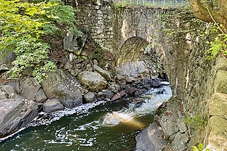
The Arch Bridge from the Boonton Ironworks crosses the Rockaway River in Grace Lord Park in the town of Boonton in Morris County, New Jersey. The single-span fieldstone arch bridge was built by John Carson Sr. in 1866 to carry a water pipe to the ironworks. It was added to the National Register of Historic Places on September 1, 2022, for its significance in engineering. It is currently used as a pedestrian bridge.
The Boonton Public Library, also known as the Holmes Library, is located at 619 Main Street in the town of Boonton in Morris County, New Jersey. Built c. 1849, the Greek Revival building was purchased by James Holmes in 1856 and became the public library in 1893. It was added to the National Register of Historic Places on November 13, 1972, for its significance in communications, education, and social history. It was added as a contributing property to the Boonton Historic District on September 29, 1980.

The Boonton Historic District is a 9-acre (3.6 ha) historic district along Main, Church, Birch, Cornelia, and Cedar Streets in the town of Boonton in Morris County, New Jersey. It was added to the National Register of Historic Places on September 29, 1980, for its significance in architecture. The district has 22 contributing buildings, including the Boonton Public Library, which was previously listed individually on the NRHP.


