Pearl Street takes its name from a prominent Lenapeshell midden that was located on its southern section, and that may have also marked a Lenape canoe landing.[1][2]
The colonial history of Pearl Street dates back to the early 1600s. A cow path at first,[3] it was laid out in 1633. It lay along a beachy area known as the Strand. Its name is an English translation of the Dutch Parelstraat (written as Paerlstraet around 1660). The street is visible on the Castello Plan along the eastern shore of New Amsterdam, together with Schreyers Hook Dock (cf. Amsterdam's Schreierstoren) built by Broad Canal as the city's first wharf in 1648.[4] It was named for the many oysters found in the river. During the period of British rule, Pearl Street was known as Great Queen Street. The "Great" was used often to differentiate from Little Queen Street, which became Cedar Street in 1784.
Pearl Street's irregular course is due to the fact that it generally followed the original eastern shoreline of the lower part of Manhattan Island, until the latter half of the 18th century when years of landfill extended the shoreline roughly 700–900 feet (200–300m) further into the East River, first to Water Street and later to Front Street.
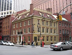
The colony's first church was built in 1633, during the tenure of director Wouter van Twiller at 39 Pearl Street, just outside the fort. In 1652 a wooden defensive wall was constructed along the town's northern perimeter to protect against possible attack by English colonists. There were two gates: the "land gate" on the Heerestraat and the "water gate" at Pearl Street. In the mid-1650s, a three-story tavern near what is now 73 Pearl Street became the city's first City Hall.[5]
Printer William Bradford lived at 81 Pearl. In 1693, he set up the first printing press in the colony.[6]
18th century
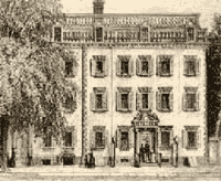
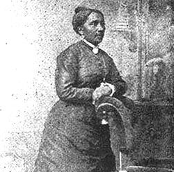
Diagram of the fire from the Long Island Star in Brooklyn, on December 21, 1835Courtyard Harper and Brothers, in 1855Elizabeth Jennings Graham
The Walton Mansion at 326 Pearl Street was a four story house built in 1752 prior to the American Revolution, known as the scene of extravagant parties. In 1784, Alexander Hamilton, and others founded the Bank of New York and set up offices in the old mansion, until moving three years later to Hanover Square; at one time a boarding house, it was taken down in 1881.
In July 1854, African American school teacher Elizabeth Jennings boarded a streetcar at the intersection of Pearl and Chatham Streets and was forcibly ejected. Chester A. Arthur, a 24-year-old attorney, was successful in a lawsuit brought against the Third Avenue Railway Company, thus beginning the gradual desegregation of all New York City transit systems by 1865.[18]
In 2014, playwright and theater artist Toni Schlesinger's The Mystery of Pearl Street about the 1997 disappearance of artists Camden Sylvia and Michael Sullivan from their Pearl Street apartment following a dispute with their landlord[19]—debuted at the Dixon Place theater.
Transportation
The IRT Third Avenueelevated railway ran above Pearl Street from August 26, 1878,[20] until December 22, 1950.[21] When the elevated structure was removed, members of the India House at 1 Hanover Square proposed a maritime-themed park at Pearl Street and Hanover Square.[22][23] The park was dedicated in November 1951.[24]
The M15 and M15 SBS run on Pearl Street east of the Fulton Street interruption until St. James Place. The eastbound M22 local bus also serves the topmost intersection of Pearl at Frankfort Street. Express service is provided by SIM5, SIM15 and SIM35 for short segments of the street.[25]
This page is based on this Wikipedia article Text is available under the CC BY-SA 4.0 license; additional terms may apply. Images, videos and audio are available under their respective licenses.