Schreierstoren

Last updated
Schreierstoren
Schreierstoren
Schreierstoren2.jpg
Amsterdam centre map.png
Red pog.svg
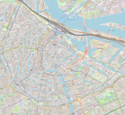
Location within Amsterdam
General information
Type Rijksmonument
Location Amsterdam
Address Prins Hendrikkade 94
1012 AE [1]
Country Netherlands
Coordinates 52°22′35″N4°54′08″E / 52.37644°N 4.90227°E / 52.37644; 4.90227 Coordinates: 52°22′35″N4°54′08″E / 52.37644°N 4.90227°E / 52.37644; 4.90227
Completed 1487
References

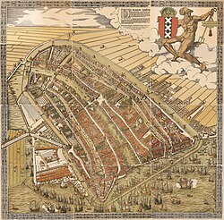
The Schreierstoren (English incorrectly translated as: Weeper's Tower or Tower of Tears), originally part of the medieval city wall of Amsterdam, the Netherlands, was built in the 15th century. It is located at the Prins Hendrikkade 94 [1] in the city center of Amsterdam. It was the location from which Henry Hudson set sail on his journey to Northern America. This expedition would lead to the discovery of the modern New York metropolitan area, which laid the foundation for Dutch colonization of the region. It was built as a defense tower in 1487. [2] It is currently a café and nautical bookstore.

Contents

Etymology

The Big Map of Amsterdam in 1544 by Cornelis Anthonisz. Depicting the sharp angle the Schreierstoren makes with the old city wall on the bottom-left. De Groote Kaart van Amsterdam in 1544 (The Big Map of Amsterdam in 1544) by Cornelis Anthonisz.jpg
The Big Map of Amsterdam in 1544 by Cornelis Anthonisz. Depicting the sharp angle the Schreierstoren makes with the old city wall on the bottom-left.

The name in Old Dutch was 'Schreyhoeckstoren' (schrey = sharp, hoeck = angle, toren = tower) referring to the sharp angle the tower makes in the once-connected city walls. [3] Later the name began to be shortened to the Schreierstoren.

Schreierstoren is incorrectly known for the fact that women wept there for their husbands, who would leave from that port, to go to war, the colonies or to fish. Most of the weeping that was done was for the fishermen who left from that port. However, this is an incorrect myth based on the confusion of the similarities of the Old Dutch word schrey meaning “sharp” and the Dutch word schreien meaning “weeping”. This confusion was further supported by the “memory tablet” in the tower, dating back to 1569, which “commemorates” a woman who was so “heart-grieved” at the departure of her husband, that she went insane. Another factor that lead to the confusion was the fact that the old city wall is demolished and the tower does not make a visible sharp corner anymore. [3]

Related Research Articles

<span class="mw-page-title-main">New Amsterdam</span> Colonial Era City

New Amsterdam was a 17th-century Dutch settlement established at the southern tip of Manhattan Island that served as the seat of the colonial government in New Netherland. The initial trading factory gave rise to the settlement around Fort Amsterdam. The fort was situated on the strategic southern tip of the island of Manhattan and was meant to defend the fur trade operations of the Dutch West India Company in the North River. In 1624, it became a provincial extension of the Dutch Republic and was designated as the capital of the province in 1625.

<span class="mw-page-title-main">Amstel</span> River in Noord-Holland, Netherlands

The Amstel is a river in the province of North Holland in the Netherlands. It flows from the Aarkanaal and Drecht in Nieuwveen northwards, passing Uithoorn, Amstelveen, and Ouderkerk aan de Amstel, to the IJ in Amsterdam. Annually, the river is the location of the Liberation Day concert, Head of the River Amstel rowing match, and the Amsterdam Gay Pride boat parade.

<span class="mw-page-title-main">Stapleton, Bristol</span> Human settlement in England

Stapleton is an area in the northeastern suburbs of the city of Bristol, England. The name is colloquially used today to describe the ribbon village along Bell Hill and Park Road in the Frome Valley. It borders Eastville to the South and Begbrook and Frenchay to the North. It comprises an eclectic mix of housing mainly from the Victorian, Edwardian, inter-war and late 20th century periods.

<span class="mw-page-title-main">Jordaan</span> Neighbourhood of Amsterdam in North Holland, Netherlands

The Jordaan is a neighbourhood of the city of Amsterdam, Netherlands. It is part of the borough of Amsterdam-Centrum. The area is bordered by the Singelgracht canal and the neighbourhood of Frederik Hendrikbuurt to the west; the Prinsengracht to the east; the Brouwersgracht to the north and the Leidsegracht to the south. The former canal Rozengracht is the main traffic artery through the neighbourhood.

<span class="mw-page-title-main">Duit</span> Coin

The duit is an old Dutch copper coin. It was manufactured in the territory of the Dutch Republic and became later an international currency. Its value was 1/8 stuiver.

<span class="mw-page-title-main">Gilgamesh flood myth</span> Flood myth in the Epic of Gilgamesh

The Gilgamesh flood myth is a flood myth in the Epic of Gilgamesh. Many scholars believe that the flood myth was added to Tablet XI in the "standard version" of the Gilgamesh Epic by an editor who used the flood story from the Epic of Atrahasis. A short reference to the flood myth is also present in the much older Sumerian Gilgamesh poems, from which the later Babylonian versions drew much of their inspiration and subject matter.

<span class="mw-page-title-main">Singel</span> Street and canal in Amsterdam

The Singel is one of the canals of Amsterdam. The Singel encircled Amsterdam in the Middle Ages, serving as a moat around the city until 1585, when Amsterdam expanded beyond the Singel. The canal runs from the IJ bay, near the Central Station, to the Muntplein square, where it meets the Amstel river. It is now the inner-most canal in Amsterdam's semicircular ring of canals.

<span class="mw-page-title-main">Basilica of Saint Nicholas, Amsterdam</span> Church in Amsterdam, Netherlands

The Basilica of Saint Nicholas is located in the Old Centre district of Amsterdam, Netherlands, very close to Amsterdam's main railway station. St, Nicholas is the patron saint of both the church and the city of Amsterdam. The basilica is the city's primary Roman Catholic church.

<span class="mw-page-title-main">Nieuwezijds Voorburgwal</span> Street in Amsterdam

The Nieuwezijds Voorburgwal is a street in the centre of Amsterdam. The street runs north-south without intersecting major streets other than the intersection with Raadhuisstraat at its halfway point, right behind the Royal Palace. On the eastern side it has a number of alleys connecting to Kalverstraat and Nieuwendijk.

<span class="mw-page-title-main">Zeedijk</span>

Zeedijk is a street in the old centre of Amsterdam. The street is the northern and eastern boundary of De Wallen red-light district and runs between Prins Hendrikkade and Nieuwmarkt. Historically an area riddled with crime and drug addicts, the area went through a revitalization and is now the main street of Amsterdam's Chinatown, where locals come to eat at Vietnamese, Thai and Chinese restaurants. The Zeedijk neighbourhood is also known as the Nautical Quarter because of its past as a sailors' neighbourhood.

<span class="mw-page-title-main">Waag, Amsterdam</span> 15th-century weigh house in Amsterdam

The Waag is a 15th-century building on Nieuwmarkt square in Amsterdam. It was originally a city gate and part of the walls of Amsterdam. Later it served as a guildhall, museum, fire station and anatomical theatre, among other things.

<span class="mw-page-title-main">Walls of Amsterdam</span> Series of historic walls built around the city of Amsterdam, Netherlands

The walls of Amsterdam were built in the Middle Ages to protect the city against attack. The Medieval walls were replaced with a series of bastions in the 17th century. In the 19th century, the walls were torn down and replaced with the Defence Line of Amsterdam, a fortification line which encircled Amsterdam at a distance from the city.

<span class="mw-page-title-main">Kloveniersburgwal, Amsterdam</span>

Kloveniersburgwal is an Amsterdam canal flowing south from Nieuwmarkt to the Amstel River on the edge of the medieval city, lying east of the dam in the centre of Amsterdam.

<span class="mw-page-title-main">Scheepvaarthuis</span>

The Shipping House is a building on the western tip of the Waalseiland near Amsterdam harbour that is one of the top 100 Dutch heritage sites and generally regarded as the first true example of the Amsterdam School, a style characterised by "expressive dynamism, lavish ornamentation and colourful embellishments". It is situated on the Prins Hendrikkade and was erected on the spot where Cornelis Houtman's first trip to the East Indies had begun in 1595. The first part was built 1913 - 1916 ; the second part was built 1926 -1928. Originally, it was the headquarters of six leading Amsterdam shipping companies: the Netherlands Steamship Company (SMN), the Royal Packet Navigation Company (KPM), the Java-China-Japan Line (JCJL) and the Royal Dutch Steamboat Company (KNSM) with subsidiary New Rhine Navigation Company (NRM) and acquired in 1912 Royal West India Mail Service (KWIM).

<span class="mw-page-title-main">Fietsflat</span> Bicycle parking facility in Amsterdam

The Fietsflat is a 3-storey free-to-use public bicycle parking facility in Amsterdam. It is located on Stationseiland island next to Amsterdam Central Station and can accommodate 2500 bicycles. The name is derived from fiets (bicycle) and flat, an originally English word which the Dutch use to denote multi-level apartment complexes.

<span class="mw-page-title-main">Geldersekade</span> Canal in Amsterdam

The Geldersekade is a canal and a street in Amsterdam that connects the Nieuwmarkt with the Prins Hendrikkade. The Geldersekade is in the easternmost part of De Wallen, the red light district, and borders Chinatown.

<span class="mw-page-title-main">Oudeschans, Amsterdam</span> Canal in Amsterdam

The Oudeschans, or Oude Schans, originally the Nieuwe Gracht, is a wide canal in the eastern part of the inner city of Amsterdam.

<span class="mw-page-title-main">Waalseilandsgracht</span> Canal in Amsterdam

The Waalseilandsgracht, or Waalseilandgracht, is a short, wide canal in the east part of the inner city of Amsterdam.

<span class="mw-page-title-main">Beeckestijn (ship)</span>

The Beeckestijn was an 18th-century Dutch slave ship working out of Amsterdam. She is depicted in front of the Dutch West India Company warehouses on the Prins Hendrikkade quay by the engraver Hendrik de Leth.

<span class="mw-page-title-main">Prins Hendrikkade</span> Street in Amsterdam

Prins Hendrikkade is a major street in the centre of Amsterdam. It passes Amsterdam Central Station, intersects the Damrak at the mouth of the Amstel river, and forms the southern end of the IJtunnel across the IJ bay. The street formed the northern edge and outer harbour of the city until the 19th century. It was named after Prince Henry of the Netherlands, youngest son of King William II, following Henry's death in 1879.

References

  1. 1 2 "Fort, vesting en -onderdelen, Prins Hendrikkade 94, 1012 AE te Amsterdam | Rijksdienst voor het Cultureel Erfgoed". monumentenregister.cultureelerfgoed.nl. Retrieved 2023-04-21.
  2. "Discover Amsterdam: Scavenger hunts, walking routes and city map".
  3. 1 2 "Schreierstoren".