Oosterdok

Last updated
Oosterdok
Native name
Dutch: Oosterdok
Amsterdam NEMO Blick vom Dach auf den Oosterdok 2.jpg
Oosterdok towards the west, seen from the roof of NEMO
Location Amsterdam
Coordinates 52°22′26″N4°54′48″E / 52.373930°N 4.913197°E / 52.373930; 4.913197
Built1832
Location map Netherlands Amsterdam Central.png
Red pog.svg
Oosterdok
Location of Oosterdok in Amsterdam

The Oosterdok ('Eastern Dock') is a former wet dock in Amsterdam. It was created in 1831-1832 by constructing the Oosterdoksdam and the Oosterdoksluis, forming a reliable deep port closed off from the tidal IJ.

Contents

Context

Silting up of Amsterdam harbor

The harbor of Amsterdam was basically a place were ships could conveniently anchor on the IJ, immediately before the city. Here smaller ships could attach to a series of interconnected mooring poles called De Laag. Larger ships anchored at a small distance from De Laag. There were docks immediately connected to the city, but these were open to the tides. Larger ships did not attach to a quay to unload, but transloaded goods on boats that brought these into the city via the many canals.

The approaches to the harbor of Amsterdam suffered from silting up. The most serious problem were the shallows near the island of Pampus in the Zuiderzee. After the French period, King William I of the Netherlands attempted to revitalize the Dutch economy by improving land- and waterways. [1] One of these was the Noordhollandsch Kanaal, which was dug from Amsterdam to Nieuwediep (Den Helder) between 1820 and 1824.

1850 map with Goudriaan Canal and Oosterdok Eerste topografische kaart omgeving Amsterdam (3382027974).jpg
1850 map with Goudriaan Canal and Oosterdok
Oosterdok Wet Dock in 1841 Oosterdok 1841 KOKA00319000001.jpg
Oosterdok Wet Dock in 1841

The Amsterdam harbor gradually became unsuitable for big ships. [2] Ships also suffered damage from anchoring before Amsterdam. This was caused by the bow and stern cutting into soft clay below the keel at ebb. The center of the ship would cut less deeply into the underground, and therefore supported the ship at ebb, causing the so-called katterug (cat's spine, or cat pose). [3] The unsuitability of the harbor meant that ships had to anchor further away.

By the late 18th century the situation had become rather desperate. At that time, the navigable part of the IJ consisted of a trench of about 400 m wide and 7-12 m deep. The 'harbor' of Amsterdam was a mud bank south of this trench, with a depth of slightly more than a meter. Therefore only small vessels could use the harbor. Ships had to unload at considerable distance. During a neap tide with a harsh south or south west wind, the harbor would occasionally go completely dry. [4]

The inhabitants of Amsterdam knew that in the past, vessels sailing to nearby European ports had anchored in the center of the city, at the Damrak. When efforts to remedy the problem by dredging had failed, they turned to science. In 1775 Jan van Houweningen suggested to give the shores of the IJ before the city a more regular profile, so the currents would increase, instead of being slowed by the many works present. [5] This idea was not executed.

In 1805 the Koninklijke Hollandsche Maatschappij der Wetenschappen offered a double gold medal in a contest to solve the problem. The contestant had to prove the causes of the silting up of the Amsterdam harbor, and propose a way to remedy this problem. [6] Jan Blanken, the engineer who later designed the Noordhollandsch Kanaal won the contest.

Plans for a wet dock

Blanken's idea was rather original. Instead of trying to remedy the situation by attempting to move the currents closer to the city, he proposed to bring the city closer to the currents. [7] Blanken proposed to lay a dam on the southern side of the IJ, north of the Laag. This would create a single large wet dock in front of the city. The plan was about to be put in motion when the French Empire fell in 1813.

After national independence was restored, the plan was again proposed to the city in 1818. The city preferred to first undertake a costly major dredging attempt for five years. By 1828 it was clear that nothing had been gained by dredging. [8]

There were two reasons to create the Amsterdam wet docks. The first was the traditional reason to construct a wet dock, i.e. to offer a safe and deep mooring place by maintaining the high tide level inside the wet dock. This could also enable large ships to unload directly to a quay, but this probably did not happen in the Oosterdok. Nevertheless, a wet dock would still ease transloading because the water would be calmer, and transloading would hardly be interrupted. This would still strengthen the competitive position of Amsterdam. For Amsterdam this traditional reason was not that relevant. The lack of a deep harbor was caused by silting up, not by a tidal range. In Amsterdam, the construction of a wet dock only to maintain the high tide, would not result in a deep harbor.

From the above it is clear that the primary reason to construct the Amsterdam wet docks, was that their dykes would put an end to the very irregular shore line of Amsterdam at the IJ, and would keep the sediment out of the harbor. It was generally agreed that the many canals opening on the IJ, the many mooring poles, De Laag, and the many ships at anchor, [9] were responsible for the quick accumulation of sediment before the city. It was hoped that the dykes of the wet docks would allow the sediment to flow back towards the Zuiderzee. The concentration of the drainage of the Amstel between the docks would also make it easier to keep the final trench to Amsterdam deep enough.

The government attempts to close off the IJ

The government of Amsterdam resisted the changed wet dock plans. The government then started the realization of the Goudriaan Canal. This was dug from 1826 to 1828 to circumvent the Pampus shallows, but not completed. The 1850 map shows the outline of this canal through Marken Island, and then through Waterland towards the IJ. [2]

In the end the city ceased to resist, because the Goudriaan plan also included the closure of the IJ on the Zuiderzee side. The city government then proposed to the king that the plan for the wet docks should be executed instead. On 10 March 1828 the king agreed, stopped the Goudriaan plan, and mandated Amsterdam to execute a revised version of Blanken's 1808 plan for the wet docks. The national government would facilitate a loan to cover the cost. [10]

History

Construction of Oosterdok

1835 city map with 'Nieuw Oostelijk Dok' 1835 S.D.U.K. City Map or Plan of Amsterdam, The Netherlands - Geographicus - Amsterdam-SUDK-1835.jpg
1835 city map with 'Nieuw Oostelijk Dok'

Construction of the Oosterdok started in May 1828. It was led by C.W.M. Klijn, director of the city maritime construction department (Stads Waterwerken). [11] The first part was a 4,194 m long dyke through the IJ from its western end near Kraansluis (Kraan Lock) to the Diemerdijk near Zeeburg in the east. The 1850 map (above) shows that this dyke enclosed the area of the Oosterdok, and an area to the east of about equals size, the Stads Rietlanden.

The dyke was located somewhat before the old mooring points Admiraliteits Boom, Keerweeers Boom, O.I. Compagnie Boom, which came to lay inside the Oosterdok. The dyke enclosed the islands Kattenburgh, Wittenburgh, and Oostenburgh, which lay north of the previous dyke, which was still called Nieuwe Zeedijk (new sea dyke). The western end of this dyke was until recently called Oosterdam. It was removed in the late 2010s in order to improve the visual quality of the area.

The Oosterdoksluis (Oosterdok Lock) would give access to the Oosterdok from the IJ. Foundation work for the lock started before the first stone was laid by on 11 June 1830 by Prince Willem, the later King William III. [11] It was a double lock, the small lock was finished early. The big lock for ocean-going ships was opened with solemn festivities in 1832.

Significance of the Oosterdok

The Marine Etablissement, with the prominent 's Lands Zeemagazijn, now National Maritime Museum, occupied about half of Kattenburgh Island. It is still a Dutch Army/Navy Base. During the French period, it became less important as a navy base, and more important as the location of Rijkswerf Amsterdam. The Rijkswerf would remain the most important shipyard for construction of Dutch warships, until it was closed down in 1915. The site then continued as Marine Etablissement.

Oostenburgh Island used to be home to the operations of the Amsterdam Division of the Dutch East India Company. Here its gigantic warehouse Oost-Indisch Zeemagazijn had collapsed in April 1822. [12] The terrain of its shipyard was soon after acquired by Van Vlissingen en Dudok van Heel. The ropewalk followed later. Van Vlissingen en Dudok van Heel would become the biggest private enterprise of Amsterdam. Its machine factory was continued by Werkspoor.

Van Vlissingen's shipbuilding activities would be restarted by the Nederlandsche Scheepsbouw Maatschappij, which was active on Conradstreet from 1894 till the mid 1920s, and then continued on the other side of the IJ. The Kattenburgervaart and Nieuwe Vaart were home to many other Amsterdam shipyards.

At the Oosterdok's southern side was Rapenburg Lock. This gave access to the Entrepotdok, a vast enclosed complex of warehouses. The oldest of these warehouses dated from 1708, but when the complex was designated as a national warehouse for transit goods (Algemeen Rijksentrepot) in April 1827, many more were constructed. [13] The close by Entrepotdok added to the attraction of Oosterdok, because ships could unload to these warehouses without having to pay import duties. These were only levied if the goods later entered the Dutch market. In 1890 a new transit dock was opened just east of the Oosterdok. This was connected to the IJ and the Merwede Canal, now the northern part of the Amsterdam–Rhine Canal.

Closed off IJ, competing railway harbor and Handelskade c. 1884 Buffa en Zonen, Afb KOKA00267000001.jpg
Closed off IJ, competing railway harbor and Handelskade c. 1884

The north eastern part of the wet dock is known by the name Dijksgracht. Here the Reederij der Drijvende Droogdokken (company for floating dry docks) opened the first wooden dry dock of Amsterdam in 1842. This was an essential facility for the maintenance of more modern ships, especially those that had copper sheathing. Soon two other wooden dry docks joined the first.

Railroads

The Oosterdokseiland came into existence when it was decided to construct the future Amsterdam Centraal station on an island in the IJ between Westerdok and Oosterdok. In 1869 the municipal council of Amsterdam agreed on this location. [14] It led to the construction of Oosterdokseiland. Most of it was made on the outside of the dyke surrounding Oosterdok, but there was also a significant part constructed inside the dock. [15] In 1874 the Amsterdam–Zutphen railway was opened, which started at the temporary Oosterdok station on Oosterdokseiland.

In the same meeting that agreed on the main passenger station, the municipal council also agreed on a central station for cargo and coal. This was to be placed just east of the Oosterdok in the Stads Rietlanden. [14] This would not be good for the Oosterdok. Therefore, the Amsterdam council also proposed a connection between the Nieuwe Vaart and the new harbor to the east. [14]

The North Sea Canal (1876)

The North Sea Canal, which opened in 1876, would be the doom of the Oosterdok. The new canal led to the closure of the IJ on its eastern side. With regard to the tides, it gave the whole IJ the characteristics of a wet dock. Therefore the old wet docks no longer had such a decisive advantage over the IJ with regard to unloading at a quay. To the contrary, both wet docks suffered from the disadvantage that ships had to cross the railroad in order to reach them. Railroad traffic soon increased to the point that ships had to wait till the late evening to cross into the Oosterdok.

Another effect of the North Sea Canal was that ships of a higher draft would reach Amsterdam. The canal would have a depth of 6.5 m below AOD in 1876 and 8.2 m in the early 1880s. The Oosterdok Lock had a depth of 6.3 m below AOD. [16] SS Willem III, the first ship of the Netherland Line had a draft of 6.7 m. Therefore, the new ocean liners which would take over the trade to the East Indies from the sailing ships, would not unload in Oosterdok.

Amsterdam Public Library, Conservatoire, and part of museum on the Oosterdok CVA33.JPG
Amsterdam Public Library, Conservatoire, and part of museum on the Oosterdok

The next phase in the development of the port of Amsterdam was the Oostelijke Handelskade, a quay constructed on the northern side of the Oosterdok dyke. From the start, this was intended for big ships that would attach directly to the quay. At the quay, modern (steam or hydraulic) cranes would quickly unload the ship into warehouses without transloading. Later, the cargo could be re-loaded onto a train, wagon or into smaller ships. This procedure of first unloading to the warehouse, and then reloading on another means of transport, was advantageous because of the low cost of (steam)powered (un)loading. It enabled a ship to quickly be on its way again. [17]

The 1960s

In the 1960s the IJtunnel was constructed. Its approach stretches through about two-thirds of the width of the dock, cutting it in two. This led to the demolishing of part of the Maritime Establishment and Navy Dock, notably the Het 'Paleis', the home for Navy officers. The construction of the IJtunnel also seriously damaged the appearance of the Oosterdok. [18] At the time, there was not much noise about this loss. At about the same time, the large classification yard on Oosterdokseiland made room for a regional main post office.

Attractions

Oosterdokseiland

National Maritime Museum Replica VOC-schip Amsterdam.jpg
National Maritime Museum

On Oosterdokseiland a large part of the former Koninklijke PTT Nederland office was demolished in 2005. A tower that was preserved at first would house the Stedelijk Museum Amsterdam from 2003 to 2010. In 2007 the Amsterdam Public Library opened on Oosterdokseiland. In 2008 it was joined by the Conservatorium van Amsterdam The remaining tower of the PTT was demolished in 2010.

Center: National Maritime Museum and NEMO

The building's Lands Zeemagazijn (National Sea Arsenal) houses the National Maritime Museum since 1973. The replica of the East India Man Amsterdam is part of this museum. With the Ministry of Defense abandoning most of the terrain of the Maritime Establishment, the grounds of the Rijkswerf are not partly open to visitors. In 1997 the NEMO Science Museum was built on top of the foundations of the IJtunnel.

Oostenburg

On Oostenburg are the main buildings of the former ropeworks of the East India Company and the Admiralty. These are called Lijnbaan van de Verenigde Oost-Indische Compagnie and Admiraliteitslijnbaan. On Conradstraat the gate of the former Nederlandsche Scheepsbouw Maatschappij is still standing.

Notes

  1. Ramaer 1924, p. 14.
  2. 1 2 De Boer 1924, p. 90.
  3. Lastdrager 1835, p. 360.
  4. Biben 1828, p. 1.
  5. Biben 1828, p. 18.
  6. Biben 1828, p. 19.
  7. Biben 1828, p. 23.
  8. Biben 1828, p. 26.
  9. Biben 1828, p. 8.
  10. Van der Vijver 1848, p. 155.
  11. 1 2 Van der Vijver 1848, p. 157.
  12. "Nederlanden". Opregte Haarlemsche Courant. 16 April 1822.
  13. "Stukken, betreffende de oprigting van een algemeen Rijks-Entrepot te Amsterdam". Groninger courant. 11 May 1827.
  14. 1 2 3 "Gemeenteraad van Amsterdam". Algemeen Handelsblad. 25 June 1869.
  15. Rosenberg 2011, p. 8.
  16. "Rapport van den Haven- en Dokmeester". Algemeen Handelsblad. 17 December 1872.
  17. "Iets over de Handelskade". Algemeen Handelsblad. 21 November 1881.
  18. "Tunnel dringt stad binnen (with map)". Het Parool. 23 January 1964.

Related Research Articles

<span class="mw-page-title-main">Noordhollandsch Kanaal</span> Canal in the Northwest Netherlands

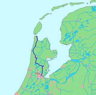
The Noordhollandsch Kanaal is a canal originally meant for ocean-going ships. It is located in North Holland, Netherlands. The canal was of great significance in Dutch history.

<span class="mw-page-title-main">Willemsoord, Den Helder</span> Maritime museum in the Netherlands

Willemsoord is a large former naval base of the Royal Netherlands Navy in Den Helder. It is now connected to the city center of Den Helder, and focuses on entertainment and tourism.

<span class="mw-page-title-main">Eastern Docklands</span> Neighborhood of Amsterdam in North Holland, Netherlands

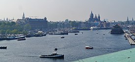
The Eastern Docklands is a neighborhood of Amsterdam, Netherlands, located between the IJ and the Nieuwe Vaart in the borough of Amsterdam-Oost. The harbor area was constructed in the late nineteenth century to allow for increasing trade with the Dutch East Indies; a new location was necessitated by the construction of the Amsterdam Centraal railway station, which replaced the old quays. East of the new station was a marshy area called De Rietlanden, with the Zeeburgerdijk, running via the Zeeburch, a fort, to the Zuiderzee.

<span class="mw-page-title-main">Voorne Canal</span> First canal to connect Rotterdam, in the Netherlands, to the sea

The Voorne Canal is a former ship canal on Voorne-Putten in South Holland, the Netherlands. It was the first canal to connect Rotterdam to the sea. Construction of the canal started in 1826 and was completed in 1829. Until the completion of the Nieuwe Waterweg in 1872 it was the main connection from Rotterdam to the sea for ocean going ships.

HNLMS <i>Cerberus</i>

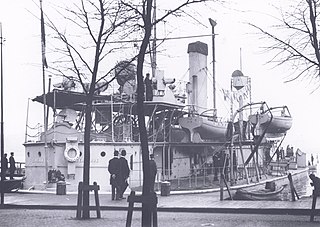
HNLMS Cerberus, was a Heiligerlee-class monitor built in Amsterdam for the Royal Netherlands Navy in the 1860s. Cerberus was a true monitor: a ship with shallow draught, only a few (heavy) guns and decent armor. These characteristics made her very suitable to operate way inland in the Dutch delta.

<span class="mw-page-title-main">Oudezijds Kolk</span> Canal in Amsterdam

The Oudezijds Kolk is a short and narrow canal/lock in Amsterdam between the Oudezijds Voorburgwal and the Oosterdok.

<span class="mw-page-title-main">Dijksgracht</span> Canal in Amsterdam

The Dijksgracht is a canal in the center of Amsterdam, north of the three Oostelijke Eilanden. It is also the name of the adjacent street.

<span class="mw-page-title-main">Oudeschans, Amsterdam</span> Canal in Amsterdam

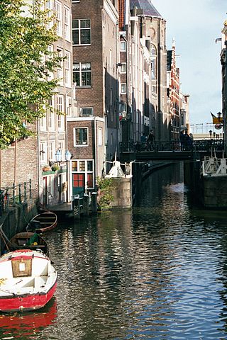
The Oudeschans, or Oude Schans, originally the Nieuwe Gracht, is a wide canal in the eastern part of the inner city of Amsterdam.

<span class="mw-page-title-main">Nederlandsche Scheepsbouw Maatschappij</span> Defunct Dutch shipbuilding company (1894-1946)

The Nederlandsche Scheepsbouw Maatschappij, was a Dutch shipbuilding company based in Amsterdam. It existed from 1894 to 1946. From c. 1908 it was the biggest Dutch shipbuilding company.

<span class="mw-page-title-main">Willemsoord Dry Dock I</span> Historic dry dock in Willemsoord, Den Helder, Netherlands

Willemsoord Dry Dock I is a historic dry dock in Willemsoord, Den Helder, Netherlands. It was constructed from 1813 till 1822, under the direction of Jan Blanken, and was part of the former Rijkswerf Willemsoord.

<span class="mw-page-title-main">Nieuwediep (river)</span> Canal and harbour

Nieuwediep was a canal and harbor. In about 1800 the major naval base Willemsoord was constructed west of it, soon followed by a major commercial port. After World War II, Nieuwe Haven Naval Base was built on reclaimed land east of the Nieuwediep, and the Nieuwdiep's source and mouth were dammed off.

Amsterdam Wooden Drydock I First floating dry dock of Amsterdam

Amsterdam Wooden Drydock I was the first floating dry dock of Amsterdam, and probably the first modern floating dry dock of Europe.

Amsterdam Wooden Drydock II Second floating dry dock of Amsterdam

Amsterdam Wooden Drydock II was the second floating dry dock of Amsterdam, and was moored in the Westerdok.

<span class="mw-page-title-main">Willem I Lock</span>

Willem I Lock is a monumental lock in Amsterdam-Noord.

<span class="mw-page-title-main">Koopvaarders Lock</span>

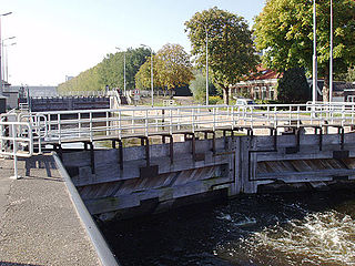
Koopvaarders Lock in Den Helder, Netherlands connects the Noordhollandsch Kanaal to the Nieuwediep. There were 4 locks at Nieuwediep carrying this name.

<span class="mw-page-title-main">Middelburg Drydock</span> Building in Zeeland, Netherlands

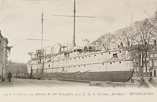
Middelburg Drydock is a former dry dock in Middelburg, Netherlands. The Dock chamber still exists.

<span class="mw-page-title-main">Amsterdamsche Droogdok Maatschappij</span> Dutch company

Amsterdamsche Droogdok Maatschappij (ADM) was a Dutch company that repaired ships using dry docks in Amsterdam, Netherlands. After World War II it also built some ships.

<span class="mw-page-title-main">Oranje Locks</span> Water management facilities near Amsterdam, Netherlands

The Oranje Locks are a group of locks and other water management facilities just east of Amsterdam.

<span class="mw-page-title-main">Wilhelmina Canal</span>

The Wilhelmina Canal is a canal in North-Brabant, Netherlands. It connects Tilburg to the Meuse, and continues to the east to connect to the Zuid-Willemsvaart north of Helmond.

<span class="mw-page-title-main">Westerdok</span> Historic site in Amsterdam

Het Westerdok is a former wet dock in Amsterdam. It was created in 1830-1834 by constructing the Westerdoksdam and Westerdoksluis, forming a reliable deep port closed off from the tidal IJ. It lost its function in 1876 when the North Sea Canal was opened. About half of it has since been filled up.

References