Description
From the Kattenburgerplein, in front of the Maritime Museum, the canal runs in a southeastern direction between the Oostelijke Eilanden (Eastern Islands) on the north side and the Kadijken on the south side. Along this section of the canal, the waterway is met from the north by the Kattenburgervaart and Wittenburgervaart via culverts, and from the south by the Entrepotdok via the Entrepotdoksluis. [1] Just west of the Entrepotdoksluis is floodgate (Nieuwe Vaartbemaling) which can be closed to block high water from the IJ. [1] At the Dageraadsbrug, the Nieuwe Vaart has a short connection with the Lozingskanaal (a extension of the Singelgracht) and continues eastwards along the Cruquiskade and the Zeeburgerpad before reaching the Zeeburgersluis, which provides access to the Amsterdam–Rhine Canal. This eastern part of the Nieuwe Vaart runs parallel to the Lozingskanaal and forms the southern boundary of the Eastern Docklands (Oostelijk Havengebied). [2]
Along the western part of the canal, on the north side (on the Eastern Islands), a street changes name four times from northwest to southeast: Kattenburgerplein - Kattenburgergracht - Wittenburgergracht - Oostenburgergracht, which together they form the Eilandboulevard. A series of discontinuous streets including, Nieuwevaart and Kruithuisstraat, run along the south side. Nieuwevaart 5-9 is the headquarters of the municipal Transport and Transport Infrastructure Department.
Bridges
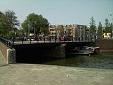
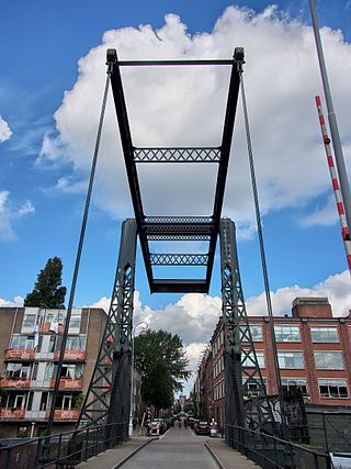
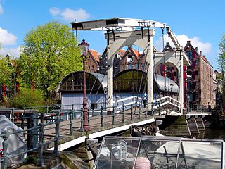
The western end of the Nieuwe Vaart is marked by the Kattenburgerbrug, which connects the Prins Hendrikkade with the Kattenburgerplein. Halfway along the western part of the canal is a pedestrian bridge called the Overhaalsgang. The Dageraadsbrug, part of a busy traffic square, carries Amsterdam Tram Line 7 across the canal. There are three bridges across the eastern part of the Nieuwe Vaart: Brug 1966, Slachthuisbrug and Ad Grimmonbrug. Just west of the Slachthuisbrug, a railway bridge for the Eastern Railway line between Amsterdam Centraal station and Amsterdam Muiderpoort railway station crosses the canal.
History
The Nieuwe Vaart was created in the 17th century when the island of Kattenburg was built outside the dykes. The island crossed so much of the IJ that silting problems arose. The Nieuwe Vaart canal was dug in 1649 to ensure a good flow of water. [3]
Originally there was only one bridge over the Nieuwe Vaart to the Eastern Islands. By lifting this Kattenburger bridge, the residents could shut themselves off from the outside world. This came in handy with the Bijltjesoproer, a riot in 1787 by Orangist ship carpenters in Kattenburg against the patriot city council. [2]
The Nieuwe Vaart also played a role in the 1917 Potato riots. A barge with potatoes was sent via the Nieuwe Vaart to the Entrepotdok on 30 June. A group of women followed the barge and started throwing stones, at which mounted police started shooting in the air. [4]
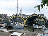
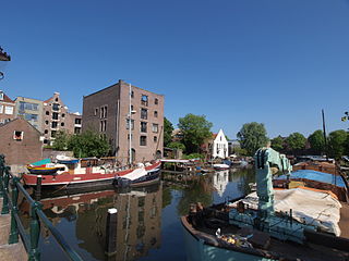
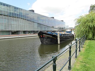
The western part of the Nieuwe Vaart has been used for shipbuilding and repair since the 17th century. With the arrival of steamships in the second half of the 19th century, more and more port activities were relocated there. The Nieuwe Vaart became the harbor basin for all large ships so that most yards made way for warehouses. [5]
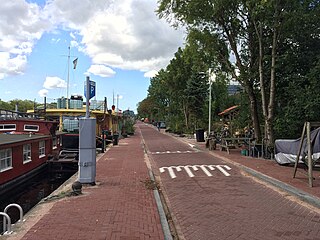
The Nieuwe Vaart Association was established in January 2011. This association represents the interests of the residents of houseboats in the western part of the Nieuwe Vaart. The association was founded by houseboat residents as a result of redevelopment plans by the Centrum district, where most of the berths for houseboats in the Nieuwe Vaart would disappear. [6]

The Singel is one of the canals of Amsterdam. The Singel encircled Amsterdam in the Middle Ages, serving as a moat around the city until 1585, when Amsterdam expanded beyond the Singel. The canal runs from the IJ bay, near the Central Station, to the Muntplein square, where it meets the Amstel river. It is now the inner-most canal in Amsterdam's semicircular ring of canals.

Amsterdam, capital of the Netherlands, has more than 100 kilometers (62 mi) of grachten (canals), about 90 islands and 1,500 bridges. The three main canals, dug in the 17th century during the Dutch Golden Age, form concentric belts around the city, known as the Grachtengordel. Alongside the main canals are 1550 monumental buildings. The 17th-century canal ring area, including the Prinsengracht, Keizersgracht, Herengracht and Jordaan, were listed as UNESCO World Heritage Site in 2010, contributing to Amsterdam's fame as the "Venice of the North".

The Grachtengordel is a neighborhood in Amsterdam, Netherlands located in the Centrum district. The seventeenth-century canals of Amsterdam, located in the center of Amsterdam, were added to the UNESCO World Heritage List in August 2010. The Amsterdam Canal District consists of the area around the city's four main canals: the Singel, the Herengracht, the Keizersgracht, and the Prinsengracht. From the Brouwersgracht, the canals are generally parallel with one another, leading gradually southeast into the Amstel river.

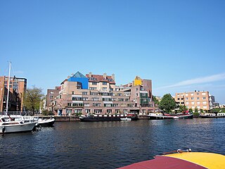
Oostelijke Eilanden, also known as Oostelijke Eilanden en Kadijken, is a neighbourhood in the centre of Amsterdam, Netherlands, consisting of Kattenburg, Wittenburg and Oostenburg.
Plantage is a neighbourhood of Amsterdam, Netherlands located in its Centrum borough. It is bordered by the Entrepotdok to the north, Plantage Muidergracht to the east and south and Nieuwe Herengracht to the west. In the centre of the neighbourhood lies the Natura Artis Magistra zoo. It had a population of 1,980 in 2017.

Schinkelbuurt is a little neighborhood of Amsterdam, Netherlands. It is located directly south of Amsterdam's city centre and it is part of the borough Amsterdam-Zuid, in the part of the city known as the Old South.

Westelijke Eilanden are three islands in the Centrum district of Amsterdam: Bickerseiland, Prinseneiland and Realeneiland. They are located to the south of the IJ and the Zeeheldenbuurt, to the north of the railway line between Central Station and Amsterdam-Sloterdijk, to the west of the Westerdok and to the east of the Planciusbuurt on the Westerkanaal. The Westelijke Eilanden form the core of the Golden Reael area, which also includes the adjacent Westerdok island, the Haarlemmerbuurt and the Planciusbuurt.
The Kadijken, also known as Kadijkseiland or Kadijkenbuurt, is a neighbourhood to the north of Artis zoo in the centre of Amsterdam. The name "Kadijken" is the plural form of Kadijk and refers to the two main streets that traverse the neighbourhood, Hoogte Kadijk and Laagte Kadijk.

The walls of Amsterdam were built in the Middle Ages to protect the city against attack. The Medieval walls were replaced with a series of bastions in the 17th century. In the 19th century, the walls were torn down and replaced with the Defence Line of Amsterdam, a fortification line which encircled Amsterdam at a distance from the city.
The Dijksgracht is a canal in the center of Amsterdam, north of the three Oostelijke Eilanden. It is also the name of the adjacent street.

The Entrepotdok, formerly Nieuwe Rapenburgergracht, is a canal in Amsterdam, and a street and row of former warehouses with the same name along the northeast side of the canal. They were constructed between 1708 and 1829, used for storage, squatted in the 1990s and are now converted into apartments. Entrepotdok is the largest inhabited warehouse complex in Amsterdam. The canal runs between the Kadijksplein and Sarphatistraat, and is parallel to Hoogte Kadijk, Laagte Kadijk, Plantage Doklaan and Natura Artis Magistra zoo.
The Entrepotdoksluis is a bridge in Amsterdam-Centrum that crosses a lock by the same name.

The Oudeschans, or Oude Schans, originally the Nieuwe Gracht, is a wide canal in the eastern part of the inner city of Amsterdam.
The Prinseneilandsgracht is a canal in the Centrum district of Amsterdam. It runs between Prinseneiland, an artificial island, to the east and the mainland to the west. Until after World War II (1939–45) the canal was bordered almost exclusively by warehouses and factories.
The Bickersgracht is a canal in the center of Amsterdam at Westelijke Eilanden, but also a street.
The Oostenburgervaart is a canal in the center of Oostenburg island, one of the Oostelijke Eilanden in Amsterdam.
The Wittenburgervaart is a short canal in Amsterdam, between the Oostelijke Eilanden.
The Kattenburgervaart is a short canal in Amsterdam that runs through the Oostelijke Eilanden. The canal separates the island of Wittenburg, which was built in the 17th century, from the island of Kattenburg. The Kattenburgervaart runs parallel to the Wittenburgervaart from the Nieuwe Vaart to the Dijksgracht.

Prins Hendrikkade is a major street in the centre of Amsterdam. It passes Amsterdam Central Station, intersects the Damrak at the mouth of the Amstel river, and forms the southern end of the IJtunnel across the IJ bay. The street formed the northern edge and outer harbour of the city until the 19th century. It was named after Prince Henry of the Netherlands, youngest son of King William II, following Henry's death in 1879.
The Oosterdok is a former wet dock in Amsterdam. It was created in 1831-1832 by constructing the Oosterdoksdam and the Oosterdoksluis, forming a reliable deep port closed off from the tidal IJ.